File:Bounds Green (Underground) Station 1860914 2020553d.jpg
Jump to navigation
Jump to search
No higher resolution available.
Bounds_Green_(Underground)_Station_1860914_2020553d.jpg (640 × 375 pixels, file size: 98 KB, MIME type: image/jpeg)
Captions
Captions
Add a one-line explanation of what this file represents
Summary
[edit]_Station_1860914_2020553d.jpg&action=edit§ion=1)
| Description |
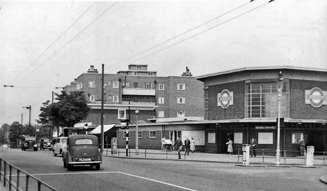
English: Bounds Green (Underground) Station, entrance. View NW on Bounds Green Road; LT Piccadilly Line to Cockfosters. (This was the site of a dreadful incident in the Blitz of 1940, when a direct hit by a bomb that penetrated to the tunnel (55 feet below the surface) killed 19 shelterers). |
| Date | |
| Source | From geograph.org.uk |
| Author | Ben Brooksbank |
| Permission (Reusing this file) |
Creative Commons Attribution Share-alike license 2.0 |
| Camera location | | View this and other nearby images on: OpenStreetMap |
|---|
_Station_1860914_2020553d.jpg¶ms=051.607064_N_-000.123974_E_globe:Earth_type:camera_heading:315.00&language=en)
Licensing
[edit]_Station_1860914_2020553d.jpg&action=edit§ion=2)

|
This image was taken from the Geograph project collection. See this photograph's page on the Geograph website for the photographer's contact details. The copyright on this image is owned by Ben Brooksbank and is licensed for reuse under the Creative Commons Attribution-ShareAlike 2.0 license.
|
This file is licensed under the Creative Commons Attribution-Share Alike 2.0 Generic license.
Attribution: Ben Brooksbank
- You are free:
- to share – to copy, distribute and transmit the work
- to remix – to adapt the work
- Under the following conditions:
- attribution – You must give appropriate credit, provide a link to the license, and indicate if changes were made. You may do so in any reasonable manner, but not in any way that suggests the licensor endorses you or your use.
- share alike – If you remix, transform, or build upon the material, you must distribute your contributions under the same or compatible license as the original.
File history
Click on a date/time to view the file as it appeared at that time.
| Date/Time | Thumbnail | Dimensions | User | Comment | |
|---|---|---|---|---|---|
| current | 14:31, 20 December 2010 | | 640 × 375 (98 KB) | Chevin (talk | contribs) | == {{int:filedesc}} == {{Information |Description={{en|1=Bounds Green (Underground) Station, entrance View NW on Bounds Green Road; LT Piccadilly Line to Cockfosters. (This was the site of a dreadful incident in the Blitz of 1940, when a direct hit by a b |
You cannot overwrite this file.
File usage on Commons
There are no pages that use this file.
File usage on other wikis
The following other wikis use this file:
- Usage on en.wikipedia.org
- Usage on nl.wikipedia.org
- Usage on simple.wikipedia.org
_Station_1860914_2020553d.jpg&oldid=939951248)