File:Boundary Stone - geograph.org.uk - 176955.jpg
Jump to navigation
Jump to search
No higher resolution available.
Boundary_Stone_-_geograph.org.uk_-_176955.jpg (640 × 480 pixels, file size: 112 KB, MIME type: image/jpeg)
Captions
Captions
Add a one-line explanation of what this file represents
Summary
[edit]
| Description |
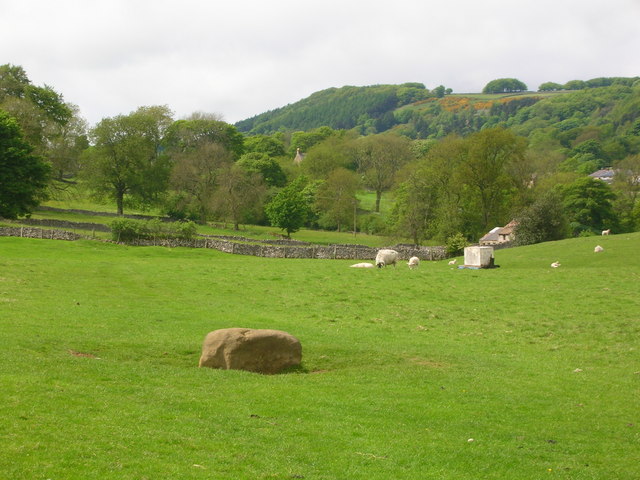
English: Boundary Stone. Boundary stone between Eyam and Stoney Middleton. When the villagers of Eyam underwent self-imposed quarantine in 1665-6 to stop the Plague from spreading out of their village the stone was their only point of contact with the outside world. Food was left here for them and to pay for it they put coins into the holes drilled in the stone and filled with vinegar to kill any germs. |
| Date | |
| Source | From geograph.org.uk |
| Author | John Darch |
| Attribution (required by the license) | John Darch / Boundary Stone / |
| Camera location | | View this and other nearby images on: OpenStreetMap |
|---|
_heading:315.00&language=en)
| Object location | | View this and other nearby images on: OpenStreetMap |
|---|
_heading:315.00&language=en)
Licensing
[edit]

|
This image was taken from the Geograph project collection. See this photograph's page on the Geograph website for the photographer's contact details. The copyright on this image is owned by John Darch and is licensed for reuse under the Creative Commons Attribution-ShareAlike 2.0 license.
|
This file is licensed under the Creative Commons Attribution-Share Alike 2.0 Generic license.
Attribution: John Darch
- You are free:
- to share – to copy, distribute and transmit the work
- to remix – to adapt the work
- Under the following conditions:
- attribution – You must give appropriate credit, provide a link to the license, and indicate if changes were made. You may do so in any reasonable manner, but not in any way that suggests the licensor endorses you or your use.
- share alike – If you remix, transform, or build upon the material, you must distribute your contributions under the same or compatible license as the original.
File history
Click on a date/time to view the file as it appeared at that time.
| Date/Time | Thumbnail | Dimensions | User | Comment | |
|---|---|---|---|---|---|
| current | 13:01, 31 January 2010 | | 640 × 480 (112 KB) | GeographBot (talk | contribs) | == {{int:filedesc}} == {{Information |description={{en|1=Boundary Stone. Boundary stone between Eyam and Stoney Middleton. When the villagers of Eyam underwent self-imposed quarantine in 1665-6 to stop the Plague from spreading out of their village the st |
You cannot overwrite this file.
File usage on Commons
There are no pages that use this file.