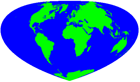
File:Bottomley projection.png
From Wikimedia Commons, the free media repository
(Redirected from File:Bottomley projection.gif)
Bottomley_projection.png (482 × 283 pixels, file size: 6 KB, MIME type: image/png)
File information
Structured data
Captions
Captions
Add a one-line explanation of what this file represents

|
This map image could be re-created using vector graphics as an SVG file. This has several advantages; see Commons:Media for cleanup for more information. If an SVG form of this image is available, please upload it and afterwards replace this template with
{{vector version available|new image name}}.
It is recommended to name the SVG file “Bottomley projection.svg”—then the template Vector version available (or Vva) does not need the new image name parameter. |
Summary
[edit]| DescriptionBottomley projection.png |
English: Bottomley world map projection |
| Source |
|
| Author | Henry Bottomley |
Licensing
[edit]| Public domainPublic domainfalsefalse |
| This work is ineligible for copyright and therefore in the public domain because it consists entirely of information that is common property and contains no original authorship. |
This file is licensed under the Creative Commons Attribution 2.0 Generic license.
- You are free:
- to share – to copy, distribute and transmit the work
- to remix – to adapt the work
- Under the following conditions:
- attribution – You must give appropriate credit, provide a link to the license, and indicate if changes were made. You may do so in any reasonable manner, but not in any way that suggests the licensor endorses you or your use.
Original upload log
[edit]| Date/Time | Dimensions | User | Comment |
|---|---|---|---|
| 23 April 2005, 15:16:59 | 482 × 283 (4986 bytes) | Henry Bottomley (talk · contribs) | Bottomley world map projection {{cc-by-2.0}} |
File history
Click on a date/time to view the file as it appeared at that time.
| Date/Time | Thumbnail | Dimensions | User | Comment | |
|---|---|---|---|---|---|
| current | 00:18, 25 August 2014 |  | 482 × 283 (6 KB) | GifTagger (talk | contribs) | Bot: Converting file to superior PNG file. (Source: Bottomley_projection.gif). This GIF was problematic due to non-greyscale color table. |
You cannot overwrite this file.
File usage on Commons
The following 2 pages use this file:
- Atlas of the World/Projections
- File:Bottomley projection.gif (file redirect)
File usage on other wikis
The following other wikis use this file:
- Usage on bh.wikipedia.org
- Usage on en.wikipedia.org
- Feature data
- Position line
- Position circle
- Spatial Data Transfer Standard
- Digital raster graphic
- Dual Independent Map Encoding
- GTOPO30
- Planimetrics
- John Adair (surveyor)
- Variscale
- Bonne projection
- Bottomley projection
- Topological map
- Hobo–Dyer projection
- Tetrad (area)
- Zhubov scale
- Hectad
- Compass Maps
- Wikipedia:WikiProject Geography
- Point of beginning
- Multimedia cartography
- Template:Cartography-stub
- Babson Globe
- Albers projection
- Behrmann projection
- Polyconic projection class
- Miller cylindrical projection
- Raleigh Ashlin Skelton
- Historical Atlas of the American West
- Roussilhe oblique stereographic projection
- Electronic Cultural Atlas Initiative
- Norge 1:50000
- MapBasic
- UDig
- Collignon projection
- Guía Roji
- Principal meridian
- Normalnull
- Digital orthophoto quadrangle
- World aeronautical chart
- Van der Grinten projection
- Internet Map Server
- Space-oblique Mercator projection
View more global usage of this file.
