File:Boston, Massachusetts (ASTER).jpg
Jump to navigation
Jump to search
Size of this preview: 800 × 310 pixels. Other resolutions: 320 × 124 pixels | 1,200 × 465 pixels.
Original file (1,200 × 465 pixels, file size: 218 KB, MIME type: image/jpeg)
Captions
Captions
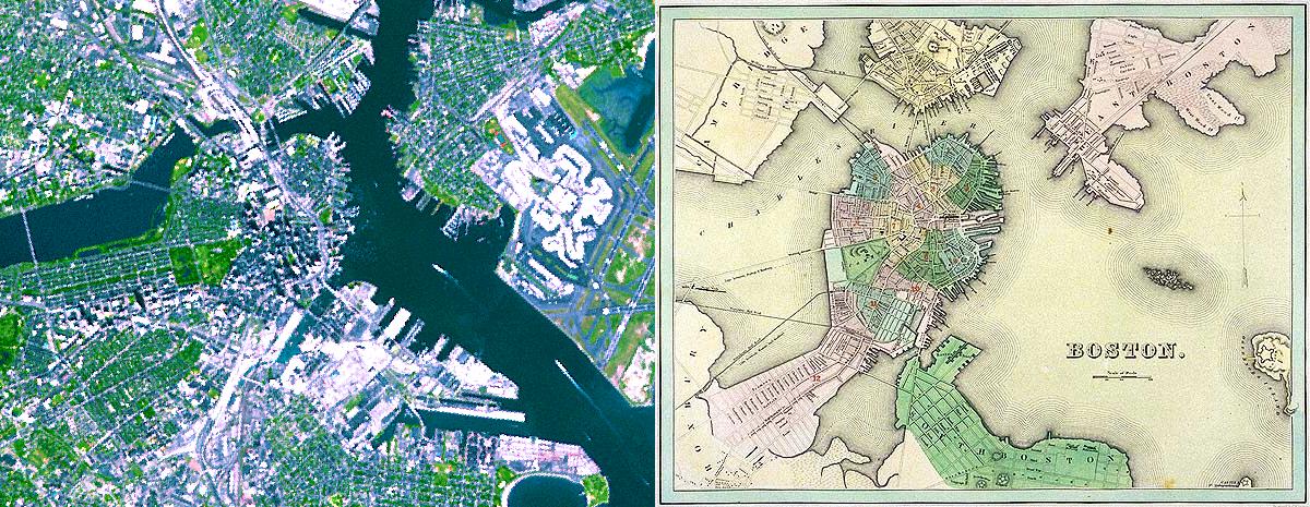
The city of Boston has grown dramatically since its original settlement in the 17th century. As seen in this 1838 map, downtown Boston was a peninsula, surrounded by several large islands and headlands across the Charles River.
Summary
[edit].jpg&action=edit§ion=1)
| Description |
English: The city of Boston has grown dramatically since its original settlement in the 17th century. As seen in this 1838 map, downtown Boston was a peninsula, surrounded by several large islands and headlands across the Charles River. In the ensuing 170 years, much of Boston Harbor and the mouth of the Charles River were filled in to create buildable land. The ASTER simulated natural color image depicts a large metropolis where land area dominates water. Notice, for example, that Logan Airport (on the right edge of the image) was once nothing but water. This image was acquired on September 7, 2001, covers an area of 9 x 7 km, and is located at 42.3 degrees north latitude and 71.1 degrees west longitude. |
||
| Date | Taken on 7 September 2001 | ||
| Source |
Boston, Massachusetts (direct link)
|
||
| Author | NASA/METI/AIST/Japan Space Systems, and U.S./Japan ASTER Science Team |
| Camera location | | View this and other nearby images on: OpenStreetMap |
|---|
.jpg¶ms=042.300000_N_-071.100000_E_globe:Earth_type:camera__&language=en)
| This media is a product of the Terra mission Credit and attribution belongs to the Advanced Spaceborne Thermal Emission and Reflection Radiometer (ASTER) team, NASA/METI/AIST/Japan Space Systems |
Licensing
[edit].jpg&action=edit§ion=2)
| This file is in the public domain in the United States because it was solely created by NASA. NASA copyright policy states that "NASA material is not protected by copyright unless noted". (See Template:PD-USGov, NASA copyright policy page or JPL Image Use Policy.) | ||
 |
Warnings:
|
File history
Click on a date/time to view the file as it appeared at that time.
| Date/Time | Thumbnail | Dimensions | User | Comment | |
|---|---|---|---|---|---|
| current | 16:26, 7 May 2023 | 1,200 × 465 (218 KB) | OptimusPrimeBot (talk | contribs) | #Spacemedia - Upload of https://asterweb.jpl.nasa.gov/gallery/images/boston-both.jpg via Commons:Spacemedia |
You cannot overwrite this file.
File usage on Commons
There are no pages that use this file.
.jpg&oldid=829809769)