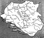
File:Bosna karta 1390.png
From Wikimedia Commons, the free media repository
Jump to navigation
Jump to search

Size of this preview: 699 × 600 pixels. Other resolutions: 280 × 240 pixels | 560 × 480 pixels | 895 × 768 pixels | 1,194 × 1,024 pixels | 1,371 × 1,176 pixels.
Original file (1,371 × 1,176 pixels, file size: 1.41 MB, MIME type: image/png)
File information
Structured data
Captions
Captions
Add a one-line explanation of what this file represents
Summary
[edit]| DescriptionBosna karta 1390.png |
English:
|
| Date | |
| Source | Own work |
| Author | BosnaSRB RS |
| Other versions |
   |
- ↑ Historijska karta SREDNJEVJEKOVOVNE BOSANSKE DRŽAVE - DIGITALNE KOLEKCIJE (in Bosanski). kolekcije.nub.ba (1957). Retrieved on 10 April 2021.
- ↑ Historijska karta srednjevjekovne bosanske države / sastavio Marko Vego ; izrada i reprodukcija Geokarta. digitalna.nsk.hr. Digitalne zbirke Nacionalne i sveučilišne knjižnice u Zagrebu. Retrieved on 10 April 2021.
- ↑ (1935) Teritorijalni razvoj bosanske države u srednjem vijeku, Glas SKA (167)
Licensing
[edit]| Public domainPublic domainfalsefalse |
| This work has been released into the public domain by its author, BosnaSRB RS. This applies worldwide. In some countries this may not be legally possible; if so: BosnaSRB RS grants anyone the right to use this work for any purpose, without any conditions, unless such conditions are required by law. Public domainPublic domainfalsefalse |
File history
Click on a date/time to view the file as it appeared at that time.
| Date/Time | Thumbnail | Dimensions | User | Comment | |
|---|---|---|---|---|---|
| current | 13:29, 4 May 2015 |  | 1,371 × 1,176 (1.41 MB) | Maxton (talk | contribs) | User created page with UploadWizard |
You cannot overwrite this file.
File usage on Commons
The following page uses this file:
File usage on other wikis
The following other wikis use this file:
- Usage on ru.wikipedia.org
Metadata
This file contains additional information such as Exif metadata which may have been added by the digital camera, scanner, or software program used to create or digitize it. If the file has been modified from its original state, some details such as the timestamp may not fully reflect those of the original file. The timestamp is only as accurate as the clock in the camera, and it may be completely wrong.
| File change date and time | 21:00, 26 March 2013 |
|---|---|
| Horizontal resolution | 118.1 dpc |
| Vertical resolution | 118.1 dpc |
Structured data
Items portrayed in this file
depicts
25 April 2015
image/png
4e126c94b0179204cb2f7cd61b8a3129c7ea5834
1,479,852 byte
1,176 pixel
1,371 pixel
Hidden category: