File:Borneo2 map russian names.svg
Jump to navigation
Jump to search

Size of this PNG preview of this SVG file: 539 × 600 pixels. Other resolutions: 216 × 240 pixels | 431 × 480 pixels | 690 × 768 pixels | 920 × 1,024 pixels | 1,840 × 2,048 pixels | 1,063 × 1,183 pixels.
Original file (SVG file, nominally 1,063 × 1,183 pixels, file size: 270 KB)
Captions
Captions
Add a one-line explanation of what this file represents
Summary
[edit]
| Description |
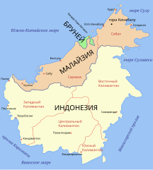
Map of Borneo, based on information from several maps.
|
| Date | |
| Source | Image:Borneo2_map_english_names.svg |
| Author | User:Mortadelo2005, translated to russian by User:Ekamaloff |
This W3C-unspecified vector image was created with Inkscape .
Licensing
[edit]

|
Permission is granted to copy, distribute and/or modify this document under the terms of the GNU Free Documentation License, Version 1.2 or any later version published by the Free Software Foundation; with no Invariant Sections, no Front-Cover Texts, and no Back-Cover Texts. A copy of the license is included in the section entitled GNU Free Documentation License. |
| This file is licensed under the Creative Commons Attribution-Share Alike 3.0 Unported license. | ||
| ||
| This licensing tag was added to this file as part of the GFDL licensing update. |
File history
Click on a date/time to view the file as it appeared at that time.
| Date/Time | Thumbnail | Dimensions | User | Comment | |
|---|---|---|---|---|---|
| current | 19:34, 14 August 2007 | | 1,063 × 1,183 (270 KB) | Ekamaloff (talk | contribs) | {{Information |Description=Map of Borneo, based on information from several maps. *Light yellow = Indonesia *Light orange = Malaysia *Green = Brunei |Source=Image:Borneo2_map_english_names.svg |Date=15 August 2007 |Author=User:Mortadelo2005, tr |
You cannot overwrite this file.
File usage on Commons
The following page uses this file:
File usage on other wikis
The following other wikis use this file:
- Usage on be.wikipedia.org
- Usage on kk.wikipedia.org
- Usage on ru.wikipedia.org
- Usage on xmf.wikipedia.org