File:Borders proposed by the Count of Aranda.svg

Original file (SVG file, nominally 983 × 639 pixels, file size: 3.39 MB)
Captions
Captions
Summary
[edit]
| Description |
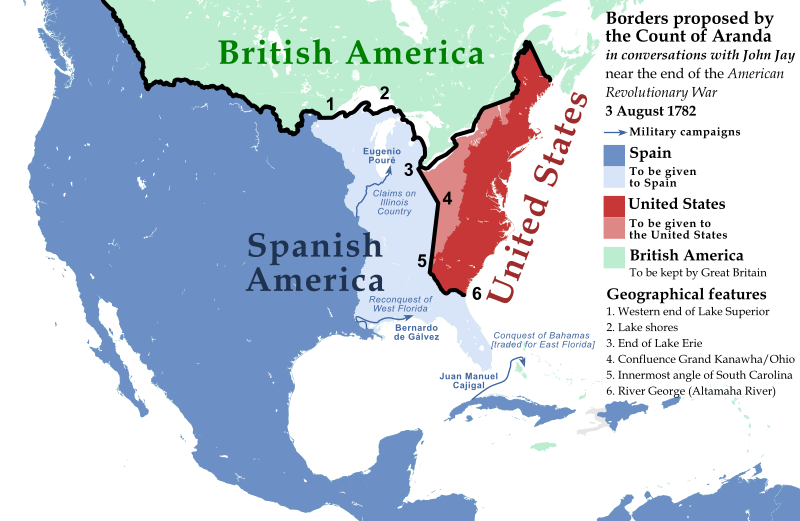
English: North American borders proposed by the Count of Aranda in conversations with John Jay near the end of the American Revolutionary War, 3 August 1782
Español: Fronteras de Norteamérica propuestas por el Conde de Aranda en conversaciones con John Jay cerca del final de la Guerra de Independencia de los Estados Unidos, 3 de agosto de 1782 |
| Date | |
| Source |
Sources: BASE MAP: File:United_States_(US49+1),_administrative_divisions_-_XY.svg Negotiations for Peace (Complete Map), 1779-1783 [PLATE 89], Atlas of the Historical Geography of the United States http://dsl.richmond.edu/historicalatlas/89/ See Line 5. The Rayneval Memoranda of 1782 on western boundaries and some comments on the French historian Doniol, by Samuel Flagg Bemis. American Antiquarian Society, April 1937 https://www.americanantiquarian.org/proceedings/44806951.pdf "Let us start at the western end of Lake Superior and follow the lake shores along as far as the end of Lake Erie or Oswego. These are positions which cannot leave lands back of them in dispute." [...] "Now we will drop the line down to the confluence of the Grand Kanawha with the Ohio," he continued, "thence to the apex of the innermost [i.e. westernmost] angle of South Carolina, so as to continue the demarcation toward some outstanding point, say a lake [Ou the Mitchell's Map used by the negotiators there is single lake near the boundary of East Florida, about 83° west longitude.], in the Apalache country, or the river George [the Altamaha river], without however going all the way, simply marking the beginning of the line so as to indicate it would go that way. We would have to stop before we get to the boundary of Georgia or of Florida until we know what their real boundaries are." Altamaha River is chosen in this representation. Pouré, Gálvez and Cajigal expeditions are shown due to their influence on the Spanish proposal. Rupert's Land claimed border is also represented (Hudson Bay watershed) and taken as the Spanish-British border. British America-US border is shown as in many other representations of the early US. |
| Author | Nagihuin |
,_administrative_divisions_-_XY.svg)
Licensing
[edit]
| This file is made available under the Creative Commons CC0 1.0 Universal Public Domain Dedication. | |
| The person who associated a work with this deed has dedicated the work to the public domain by waiving all of their rights to the work worldwide under copyright law, including all related and neighboring rights, to the extent allowed by law. You can copy, modify, distribute and perform the work, even for commercial purposes, all without asking permission.
|
File history
Click on a date/time to view the file as it appeared at that time.
| Date/Time | Thumbnail | Dimensions | User | Comment | |
|---|---|---|---|---|---|
| current | 16:17, 1 August 2019 | | 983 × 639 (3.39 MB) | Nagihuin (talk | contribs) | Corrected old Maine borders. |
| 00:20, 28 July 2019 |  | 983 × 639 (3.39 MB) | Nagihuin (talk | contribs) | User created page with UploadWizard |
You cannot overwrite this file.
File usage on Commons
The following 2 pages use this file:
File usage on other wikis
The following other wikis use this file:
- Usage on en.wikipedia.org
- Usage on he.wikipedia.org
- Usage on uz.wikipedia.org
- Usage on vi.wikipedia.org