File:Border satellite view.jpg
Jump to navigation
Jump to search

Size of this preview: 561 × 600 pixels. Other resolutions: 225 × 240 pixels | 449 × 480 pixels | 742 × 793 pixels.
Original file (742 × 793 pixels, file size: 191 KB, MIME type: image/jpeg)
Captions
Captions
Add a one-line explanation of what this file represents
Summary
[edit]
| Description |
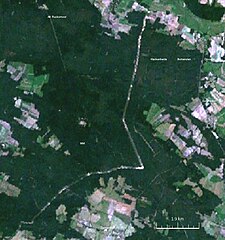
English: Satellite view of a stretch of the former inner German border between Nienwalde (Lower Saxony) and Arendsee (Saxony-Anhalt). |
| Date | |
| Source | NASA World Wind |
| Author | NASA World Wind |
Licensing
[edit]
| This image is in the public domain because it is a screenshot from NASA’s globe software World Wind using a public domain layer, such as Blue Marble, MODIS, Landsat, SRTM, USGS or GLOBE.
|
 |
File history
Click on a date/time to view the file as it appeared at that time.
| Date/Time | Thumbnail | Dimensions | User | Comment | |
|---|---|---|---|---|---|
| current | 10:52, 1 November 2009 | | 742 × 793 (191 KB) | ChrisO (talk | contribs) | {{Information |Description={{en|1=Satellite view of a stretch of the former inner German border between Nienwalde (Lower Saxony) and Arendsee (Saxony-Anhalt).}} |Source=NASA World Wind |Author=NASA World Wind |Date=2009-11-01 |Permission= |other_versions= |
You cannot overwrite this file.
File usage on Commons
There are no pages that use this file.