File:BonnevilleDam map.jpg
Jump to navigation
Jump to search

Size of this preview: 800 × 540 pixels. Other resolutions: 320 × 216 pixels | 640 × 432 pixels | 1,024 × 691 pixels | 1,280 × 864 pixels | 2,437 × 1,645 pixels.
Original file (2,437 × 1,645 pixels, file size: 172 KB, MIME type: image/jpeg)
Captions
Captions
Add a one-line explanation of what this file represents
Summary
[edit]
| Description |
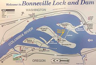
English: Map of Bonneville Dam in Columbia River, Oregon, US Nederlands: Overzichtskaart van de Bonneville dam en waterkrachtcentrale in de Columbia rivier (Oregon) |
| Date | |
| Source | Own work |
| Author | Zandcee |
Licensing
[edit]
This image or file is a work of a U.S. Army Corps of Engineers soldier or employee, taken or made as part of that person's official duties. As a work of the U.S. federal government, the image is in the public domain.
|
File history
Click on a date/time to view the file as it appeared at that time.
| Date/Time | Thumbnail | Dimensions | User | Comment | |
|---|---|---|---|---|---|
| current | 10:15, 8 June 2013 | | 2,437 × 1,645 (172 KB) | Zandcee (talk | contribs) | User created page with UploadWizard |
You cannot overwrite this file.
File usage on Commons
There are no pages that use this file.