File:Bolsover (Midland) railway station.jpg
Jump to navigation
Jump to search
No higher resolution available.
Bolsover_(Midland)_railway_station.jpg (640 × 409 pixels, file size: 150 KB, MIME type: image/jpeg)
Captions
Captions
Add a one-line explanation of what this file represents
Summary
[edit]_railway_station.jpg&action=edit§ion=1)
| Description |
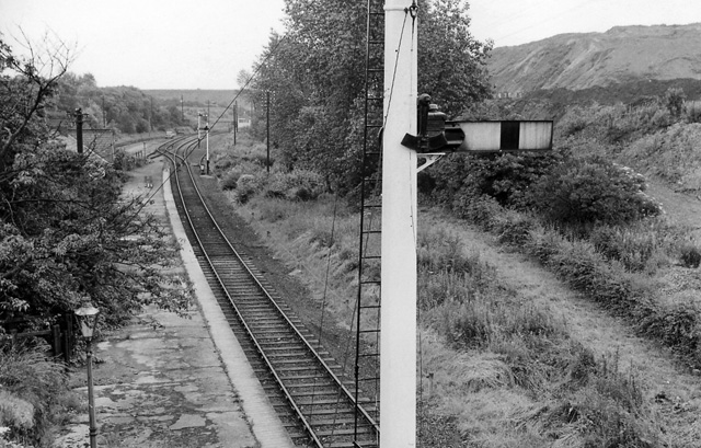
English: Bolsover (Midland) Station (remains).
View southward, towards Pleasley and Mansfield; ex-Midland Mansfield - Pleasley - Staveley - Chesterfield line. Station closed 28/7/30 to passengers (excursions until 1939), to goods 1/11/62, but was reopened 28/7/77 - 1981! The line continued to carry colliery traffic until fairly recently and it is shown on the modern map as 'disused' |
| Date | Taken on 13 July 1963 |
| Source | From geograph.org.uk |
| Author | Ben Brooksbank |
| Permission (Reusing this file) |
Creative Commons Attribution Share-alike license 2.0 |
| Attribution (required by the license) | Ben Brooksbank / Bolsover (Midland) Station (remains) / |
| Camera location | | View this and other nearby images on: OpenStreetMap |
|---|
_railway_station.jpg¶ms=053.231601_N_-001.308447_E_globe:Earth_type:camera_heading:157.00&language=en)
Licensing
[edit]_railway_station.jpg&action=edit§ion=2)

|
This image was taken from the Geograph project collection. See this photograph's page on the Geograph website for the photographer's contact details. The copyright on this image is owned by Ben Brooksbank and is licensed for reuse under the Creative Commons Attribution-ShareAlike 2.0 license.
|
This file is licensed under the Creative Commons Attribution-Share Alike 2.0 Generic license.
Attribution: Ben Brooksbank
- You are free:
- to share – to copy, distribute and transmit the work
- to remix – to adapt the work
- Under the following conditions:
- attribution – You must give appropriate credit, provide a link to the license, and indicate if changes were made. You may do so in any reasonable manner, but not in any way that suggests the licensor endorses you or your use.
- share alike – If you remix, transform, or build upon the material, you must distribute your contributions under the same or compatible license as the original.
File history
Click on a date/time to view the file as it appeared at that time.
| Date/Time | Thumbnail | Dimensions | User | Comment | |
|---|---|---|---|---|---|
| current | 15:01, 10 May 2010 | | 640 × 409 (150 KB) | Chevin (talk | contribs) | == {{int:filedesc}} == {{Information |Description={{en|1=Bolsover (Midland) Station (remains)}} View southward, towards Pleasley and Mansfield; ex-Midland Mansfield - Pleasley - Staveley - Chesterfield line. Station closed 28/7/30 to passengers (excursion |
You cannot overwrite this file.
File usage on Commons
The following 2 pages use this file:
File usage on other wikis
The following other wikis use this file:
- Usage on en.wikipedia.org
- Usage on www.wikidata.org
_railway_station.jpg&oldid=828264806)