File:Bold Quest 21-1 DVIDS603282.jpg
Original file (2,196 × 1,569 pixels, file size: 447 KB, MIME type: image/jpeg)
Captions
Summary
[edit]DescriptionBold Quest 21-1 DVIDS603282.jpg |
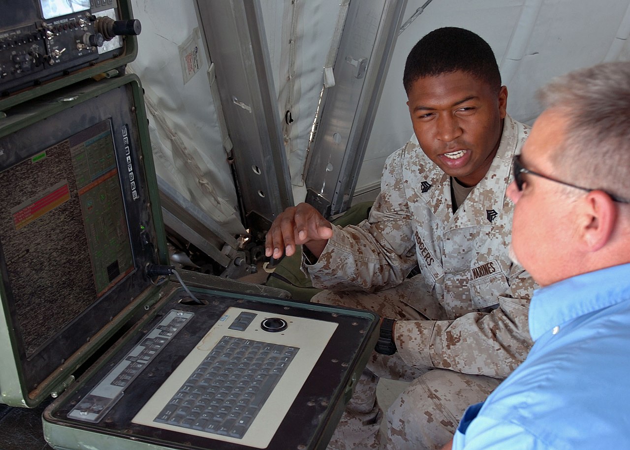
English: Marine Sgt. Branden Rogers from Phoenix, an unmanned aerial vehicle technician with Marine Unmanned Aerial Vehicle Squadron 3 at Marine Corps Air Ground Combat Center Twentynine Palms, Calif., demonstrates the Portable Ground Control Station and Data Terminal's capabilities to Bill Black, from North Vernon, Ind., during Bold Quest 12-1, June 13 at Camp Atterbury Joint Maneuver Training Center. Twelve nations are participating in
or observing in Bold Quest 12-1, is a two-week Joint Staff sponsored coalition air-combat assessment exercise utilizing multiple training venues across Indiana including Muscatatuck Urban Training Center and Fort Wayne, Ind. Bold Quest 2012, part of the Coalition Capabilities Demonstration and Assessment Series, focuses on testing Digitally Aided Close Air Support technologies, which will help reduce friendly fire incidents, enhance combat effectiveness, and increase situational awareness.
|
|||
Date | Taken on 13 June 2012 | |||
Source | https://www.dvidshub.net/image/603282/bold-quest-21-1 | |||
Author | Sgt. William Hill | |||
Location InfoField | CAMP ATTERBURY, IN, US | |||
VIRIN InfoField |
|
|||
Posted InfoField | 14 June 2012, 23:55 | |||
Archive link InfoField | archive copy at the Wayback Machine |
Licensing
[edit]Public domainPublic domainfalsefalse |
This file is a work of a U.S. Army soldier or employee, taken or made as part of that person's official duties. As a work of the U.S. federal government, it is in the public domain in the United States.
العربية ∙ বাংলা ∙ català ∙ čeština ∙ Deutsch ∙ English ∙ español ∙ eesti ∙ فارسی ∙ suomi ∙ français ∙ hrvatski ∙ magyar ∙ Bahasa Indonesia ∙ italiano ∙ 日本語 ∙ 한국어 ∙ lietuvių ∙ македонски ∙ മലയാളം ∙ မြန်မာဘာသာ ∙ Nederlands ∙ polski ∙ português ∙ русский ∙ sicilianu ∙ српски / srpski ∙ Türkçe ∙ українська ∙ Tiếng Việt ∙ 中文(简体) ∙ 中文(繁體) ∙ +/− |
File history
Click on a date/time to view the file as it appeared at that time.
Date/Time | Thumbnail | Dimensions | User | Comment | |
---|---|---|---|---|---|
current | 01:48, 8 March 2017 | 2,196 × 1,569 (447 KB) | Fæ (talk | contribs) | DVIDS 3 megapixel image from https://www.dvidshub.net/image/603282/bold-quest-21-1. Ind.; Marine Corps Air Ground Combat Center Twentynine Palms; demonstrates; technologies. Part of User:Fæ/Project list/DoD |
You cannot overwrite this file.
File usage on Commons
There are no pages that use this file.
Metadata
This file contains additional information such as Exif metadata which may have been added by the digital camera, scanner, or software program used to create or digitize it. If the file has been modified from its original state, some details such as the timestamp may not fully reflect those of the original file. The timestamp is only as accurate as the clock in the camera, and it may be completely wrong.
Camera manufacturer | NIKON CORPORATION |
---|---|
Camera model | NIKON D2Hs |
Exposure time | 1/50 sec (0.02) |
F-number | f/5 |
ISO speed rating | 200 |
Date and time of data generation | 20:09, 13 June 2012 |
Lens focal length | 31 mm |
Headline | Bold Quest 21-1 |
Credit/Provider | Army |
Source | Digital |
City shown | Camp Atterbury |
Short title | 120613-A-1826H-174 |
Author | Bold Quest, Sgt. William Hill |
Image title | Marine Sgt. Branden Rogers from Phoenix, an unmanned aerial vehicle technician with Marine Unmanned Aerial Vehicle Squadron 3 at Marine Corps Air Ground Combat Center Twentynine Palms, Calif., demonstrates the Portable Ground Control Station and Data Terminal's capabilities to Bill Black, from North Vernon, Ind., during Bold Quest 12-1, June 13 at Camp Atterbury Joint Maneuver Training Center. Twelve nations are participating in
or observing in Bold Quest 12-1, is a two-week Joint Staff sponsored coalition air-combat assessment exercise utilizing multiple training venues across Indiana including Muscatatuck Urban Training Center and Fort Wayne, Ind. Bold Quest 2012, part of the Coalition Capabilities Demonstration and Assessment Series, focuses on testing Digitally Aided Close Air Support technologies, which will help reduce friendly fire incidents, enhance combat effectiveness, and increase situational awareness. |
Copyright holder | Public Domain |
Orientation | Normal |
Horizontal resolution | 314 dpi |
Vertical resolution | 314 dpi |
Software used | Ver.1.01 |
File change date and time | 15:38, 13 June 2012 |
Y and C positioning | Co-sited |
Exposure Program | Manual |
Exif version | 2.21 |
Date and time of digitizing | 20:09, 13 June 2012 |
Meaning of each component |
|
Image compression mode | 4 |
APEX shutter speed | 5.643856 |
APEX aperture | 4.643856 |
APEX exposure bias | 0 |
Maximum land aperture | 3 APEX (f/2.83) |
Metering mode | Pattern |
Light source | Unknown |
Flash | Flash did not fire |
Supported Flashpix version | 1 |
Color space | sRGB |
Sensing method | One-chip color area sensor |
File source | Digital still camera |
Scene type | A directly photographed image |
Custom image processing | Normal process |
Exposure mode | Manual exposure |
White balance | Auto white balance |
Digital zoom ratio | 1 |
Focal length in 35 mm film | 46 mm |
Scene capture type | Standard |
Scene control | None |
Contrast | Soft |
Saturation | Normal |
Sharpness | Normal |
Subject distance range | Unknown |
GPS tag version | 2.2.0.0 |
Date metadata was last modified | 19:45, 14 June 2012 |
Original transmission location code | Camp Atterbury |
Special instructions | Released
Halladay, Jessica A CPT MIL NG IN ARNG <jessica.a.halladay@us.army.mil> via DVIDS |
Unique ID of original document | xmp.did:3A90CD338FB5E111B518DD9EEC27F478 |
Keywords |
|
Province or state shown | IN |
Country shown | United States |
Code for country shown | US |