File:Bois des Caryers.png
Jump to navigation
Jump to search

Size of this preview: 800 × 514 pixels. Other resolutions: 320 × 206 pixels | 640 × 411 pixels | 836 × 537 pixels.
Original file (836 × 537 pixels, file size: 402 KB, MIME type: image/png)
Captions
Captions
Add a one-line explanation of what this file represents
Summary
[edit]
| Description |
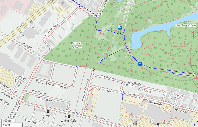
Français : Bois des Caryers, nom d'un parc de conservation (forme triangulaire) à LaSalle, adjacent au parc Angrignon. Au sud du parc du Bois-des-Caryers, a été développé un quartier résidentiel, d'abord dans le cadre du projet Bois-des-Caryers, puis sous l'appellation Bobois. |
| Date | |
| Source | Own work à partir de openstreetmap.org |
| Author | Jeangagnon |
| Camera location | | View this and other nearby images on: OpenStreetMap |
|---|
Licensing
[edit]
| This work has been released into the public domain by its author, OpenStreetMap. This applies worldwide. In some countries this may not be legally possible; if so: OpenStreetMap grants anyone the right to use this work for any purpose, without any conditions, unless such conditions are required by law. |
File history
Click on a date/time to view the file as it appeared at that time.
| Date/Time | Thumbnail | Dimensions | User | Comment | |
|---|---|---|---|---|---|
| current | 13:23, 18 June 2023 | | 836 × 537 (402 KB) | Jeangagnon (talk | contribs) | Uploaded own work with UploadWizard |
You cannot overwrite this file.
File usage on Commons
There are no pages that use this file.