File:Bohus1678.jpg

Original file (3,508 × 2,552 pixels, file size: 1.2 MB, MIME type: image/jpeg)
Captions
Captions
Summary
[edit]
| Description |
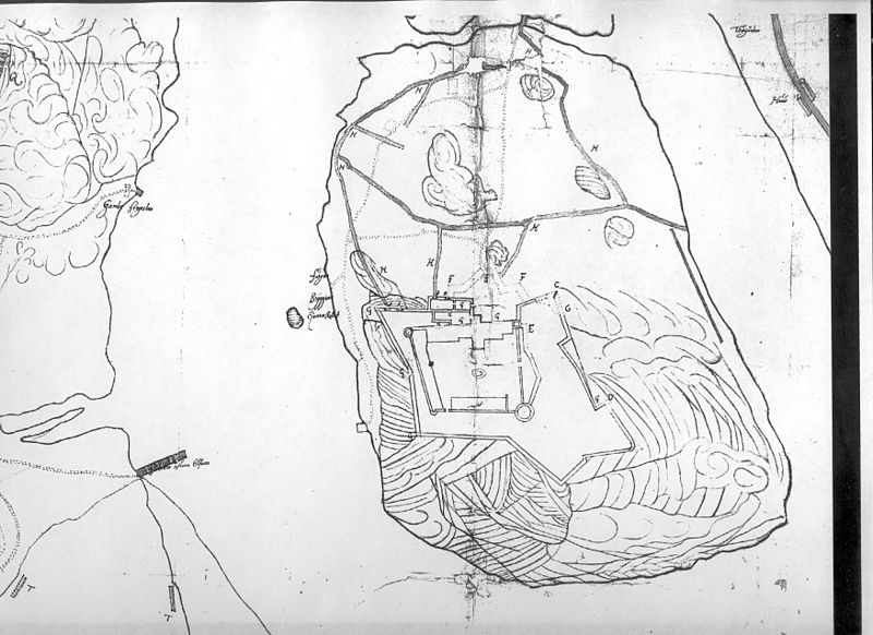
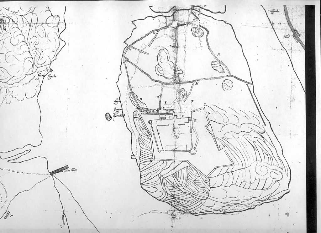
English: Detail of a swedish map dated 31 july 1678 showing the damages on the fortress Bohus after the just ended siege.
A and B Holes in the wall caused by explosive charges. C Severe damage on the bastion Nedre Platt caused by explosive chages. F Tenaille completely destroyed by explosive charges. G Holes in the wall caused by cannonfire. H Danish-norwegian trenches. Q One of the danish-norwegian cannonbatteries placed on the island Hisingen. T Danish-norwegian trenches on the island Hisingen.Svenska: Detalj av karta daterad 31 juli 1678 över skadorna på Bohus fästning efter den just avslutade belägringen.
A Bäscher i muren på bastion Munken efter två minor. B Bräscher i muren vid Svingeln och yttre porten efter två minor. C Omfattande bräsch i bastionen Nedre Platt efter två minor. D Bräsch i bastionen Skarpe Nord efter kanonbeskjutning. E Bräsch i högverket Övre Platts norra vinkel efter kanonbeskjutning. F Tenaljen framför fästningsporten totalförstörd av dansk-norska mineringar. G Bräscher i murarna orsakade av kanonbeskjutning. H Dansk-norska löpgravar in mot fästningen. Q Ett av de dansk-norska kanonbatterierna på Hisingen. T Dansk-norska löpgravar på Hisingen. |
| Date | |
| Source | Krigsarkivet, Stockholm ; Sveriges Krig 8:91 |
| Author | Anonymous |
| Other versions |
Derivative works of this file: |
Licensing
[edit]
|
This work is in the public domain in its country of origin and other countries and areas where the copyright term is the author's life plus 100 years or fewer. | |
| This file has been identified as being free of known restrictions under copyright law, including all related and neighboring rights. | |
File history
Click on a date/time to view the file as it appeared at that time.
| Date/Time | Thumbnail | Dimensions | User | Comment | |
|---|---|---|---|---|---|
| current | 17:26, 24 February 2011 | | 3,508 × 2,552 (1.2 MB) | Dagjoh (talk | contribs) | {{Information |Description ={{en|1=Detail of a swedish map dated 31 july 1678 showing the damages on the fortress Bohus after the just ended siege. A and B Holes in the wall caused by explosive charges. C Severe damage on the bastion Nedre Platt cause |
You cannot overwrite this file.
File usage on Commons
The following 2 pages use this file: