File:Bogenberg Panorama 06.jpg
Original file (6,799 × 3,824 pixels, file size: 11.7 MB, MIME type: image/jpeg)
Captions
Summary
[edit]DescriptionBogenberg Panorama 06.jpg |
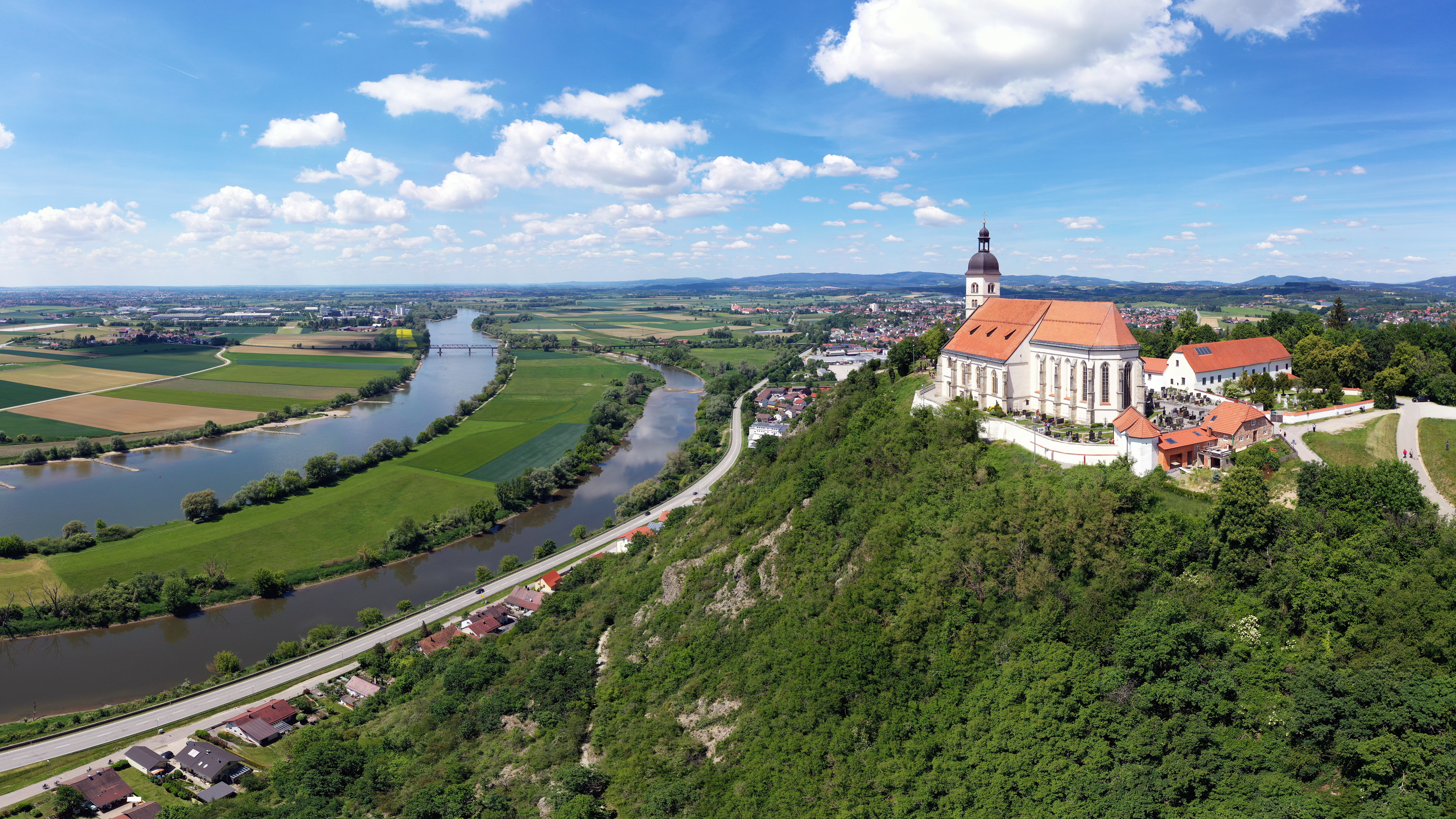
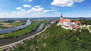
Deutsch: Luftbild des Bogenberg nahe der niederbayerischen Stadt Bogen. Außerdem zu sehen ist die Wallfahrtskirche Mariä Himmelfahrt, das Kreismuseum Bogenberg und die Donau/Donauauen. |
Date | |
Source | Own work |
Author | SimonWaldherr |
Camera location | 48° 54′ 02.5″ N, 12° 41′ 50.92″ E | View this and other nearby images on: OpenStreetMap | 48.900694; 12.697479 |
---|
Licensing
[edit]- You are free:
- to share – to copy, distribute and transmit the work
- to remix – to adapt the work
- Under the following conditions:
- attribution – You must give appropriate credit, provide a link to the license, and indicate if changes were made. You may do so in any reasonable manner, but not in any way that suggests the licensor endorses you or your use.
- share alike – If you remix, transform, or build upon the material, you must distribute your contributions under the same or compatible license as the original.
This image was uploaded as part of Wiki Loves Earth 2020.
aragonés ∙ العربية ∙ asturianu ∙ azərbaycanca ∙ беларуская (тарашкевіца) ∙ български ∙ বাংলা ∙ brezhoneg ∙ català ∙ čeština ∙ Cymraeg ∙ Deutsch ∙ Ελληνικά ∙ English ∙ español ∙ eesti ∙ euskara ∙ فارسی ∙ français ∙ galego ∙ עברית ∙ hrvatski ∙ հայերեն ∙ Bahasa Indonesia ∙ italiano ∙ 日本語 ∙ ქართული ∙ 한국어 ∙ latviešu ∙ македонски ∙ മലയാളം ∙ मराठी ∙ Bahasa Melayu ∙ norsk bokmål ∙ नेपाली ∙ Nederlands ∙ norsk ∙ polski ∙ português ∙ português do Brasil ∙ română ∙ русский ∙ sicilianu ∙ shqip ∙ slovenščina ∙ српски / srpski ∙ svenska ∙ ไทย ∙ Türkçe ∙ українська ∙ اردو ∙ 简体中文 ∙ 繁體中文 ∙ +/− |
This image has been assessed using the Quality image guidelines and is considered a Quality image.
العربية ∙ جازايرية ∙ беларуская ∙ беларуская (тарашкевіца) ∙ български ∙ বাংলা ∙ català ∙ čeština ∙ Cymraeg ∙ Deutsch ∙ Schweizer Hochdeutsch ∙ Zazaki ∙ Ελληνικά ∙ English ∙ Esperanto ∙ español ∙ eesti ∙ euskara ∙ فارسی ∙ suomi ∙ français ∙ galego ∙ עברית ∙ हिन्दी ∙ hrvatski ∙ magyar ∙ հայերեն ∙ Bahasa Indonesia ∙ italiano ∙ 日本語 ∙ Jawa ∙ ქართული ∙ 한국어 ∙ kurdî ∙ Lëtzebuergesch ∙ lietuvių ∙ македонски ∙ മലയാളം ∙ मराठी ∙ Bahasa Melayu ∙ Nederlands ∙ Norfuk / Pitkern ∙ polski ∙ português ∙ português do Brasil ∙ rumantsch ∙ română ∙ русский ∙ sicilianu ∙ slovenčina ∙ slovenščina ∙ shqip ∙ српски / srpski ∙ svenska ∙ தமிழ் ∙ తెలుగు ∙ ไทย ∙ Tagalog ∙ toki pona ∙ Türkçe ∙ українська ∙ vèneto ∙ Tiếng Việt ∙ 中文 ∙ 中文(简体) ∙ 中文(繁體) ∙ +/− |
File history
Click on a date/time to view the file as it appeared at that time.
Date/Time | Thumbnail | Dimensions | User | Comment | |
---|---|---|---|---|---|
current | 21:54, 21 June 2020 | 6,799 × 3,824 (11.7 MB) | SimonWaldherr (talk | contribs) | Uploaded own work with UploadWizard |
You cannot overwrite this file.
File usage on Commons
The following 5 pages use this file:
File usage on other wikis
The following other wikis use this file:
- Usage on de.wikipedia.org
Metadata
This file contains additional information such as Exif metadata which may have been added by the digital camera, scanner, or software program used to create or digitize it. If the file has been modified from its original state, some details such as the timestamp may not fully reflect those of the original file. The timestamp is only as accurate as the clock in the camera, and it may be completely wrong.
Image title |
|
---|---|
Camera manufacturer | Hasselblad |
Camera model | L1D-20c |
Author | Simon Waldherr |
Exposure time | 1/1,250 sec (0.0008) |
F-number | f/3.2 |
ISO speed rating | 100 |
Date and time of data generation | 13:18, 21 May 2020 |
Lens focal length | 10.3 mm |
Latitude | 48° 54′ 2.5″ N |
Longitude | 12° 41′ 50.92″ E |
Altitude | 458 meters above sea level |
Width | 6,799 px |
Height | 4,411 px |
Bits per component |
|
Pixel composition | RGB |
Orientation | Normal |
Number of components | 3 |
Horizontal resolution | 72 dpi |
Vertical resolution | 72 dpi |
Software used | Adobe Photoshop CC 2017 (Macintosh) |
File change date and time | 21:17, 11 June 2020 |
Subsampling ratio of Y to C | 0 |
Y and C positioning | Centered |
Exposure Program | Aperture priority |
Exif version | 2.3 |
Date and time of digitizing | 13:18, 21 May 2020 |
Meaning of each component |
|
APEX shutter speed | 10.287712 |
APEX aperture | 3.356144 |
APEX exposure bias | 0 |
Maximum land aperture | 2.9708536585366 APEX (f/2.8) |
Metering mode | Average |
Light source | Daylight |
Flash | Flash did not fire |
Supported Flashpix version | 1 |
Color space | sRGB |
File source | Digital still camera |
Scene type | A directly photographed image |
Exposure mode | Auto exposure |
White balance | Auto white balance |
Digital zoom ratio | 1 |
Focal length in 35 mm film | 28 mm |
Scene capture type | Standard |
Scene control | None |
Contrast | Normal |
Saturation | Normal |
Sharpness | Normal |
GPS tag version | 0.0.3.2 |
Serial number of camera | 0K8TF7B0026492 |
Lens used | 28.0 mm f/2.8 |
Date metadata was last modified | 23:17, 11 June 2020 |
Unique ID of original document | F263DE2249B2459A63089CA7E396840F |
IIM version | 4 |
Structured data
Items portrayed in this file
depicts
21 May 2020
48°54'2.498"N, 12°41'50.924"E
0.0008 second
3.2
10.3 millimetre
100
image/jpeg
3aadba9b12eeb6733db736d255d71356a5602660
12,267,536 byte
3,824 pixel
6,799 pixel
- Aerial photographs of Bavaria
- Bogenberg
- Mariä Himmelfahrt (Bogenberg)
- Danube in Landkreis Straubing-Bogen
- Nature of Landkreis Straubing-Bogen
- Views from Bogenberg
- Aiterhofen
- FFH-Gebiet Donauauen zwischen Straubing und Vilshofen
- Naturschutzgebiet Bogenberg
- Vogelschutzgebiet Donau zwischen Straubing und Vilshofen
- Files with coordinates missing SDC location of creation
- CC-BY-SA-4.0
- Self-published work
- Images from Wiki Loves Earth 2020
- Images from Wiki Loves Earth 2020 in Germany
- Images from Wiki Loves Earth missing SDC location of creation
- Images from Wiki Loves Earth 2020, DE-BY
- Uploaded via Campaign:wle-de-by
- Quality images from Wiki Loves Earth 2020 in Germany
- Quality images
- Quality images of the Danube