File:Bloom at Tapajós River.jpg
Original file (2,500 × 3,900 pixels, file size: 1.81 MB, MIME type: image/jpeg)
Captions
Captions
Summary
[edit]
| Description |
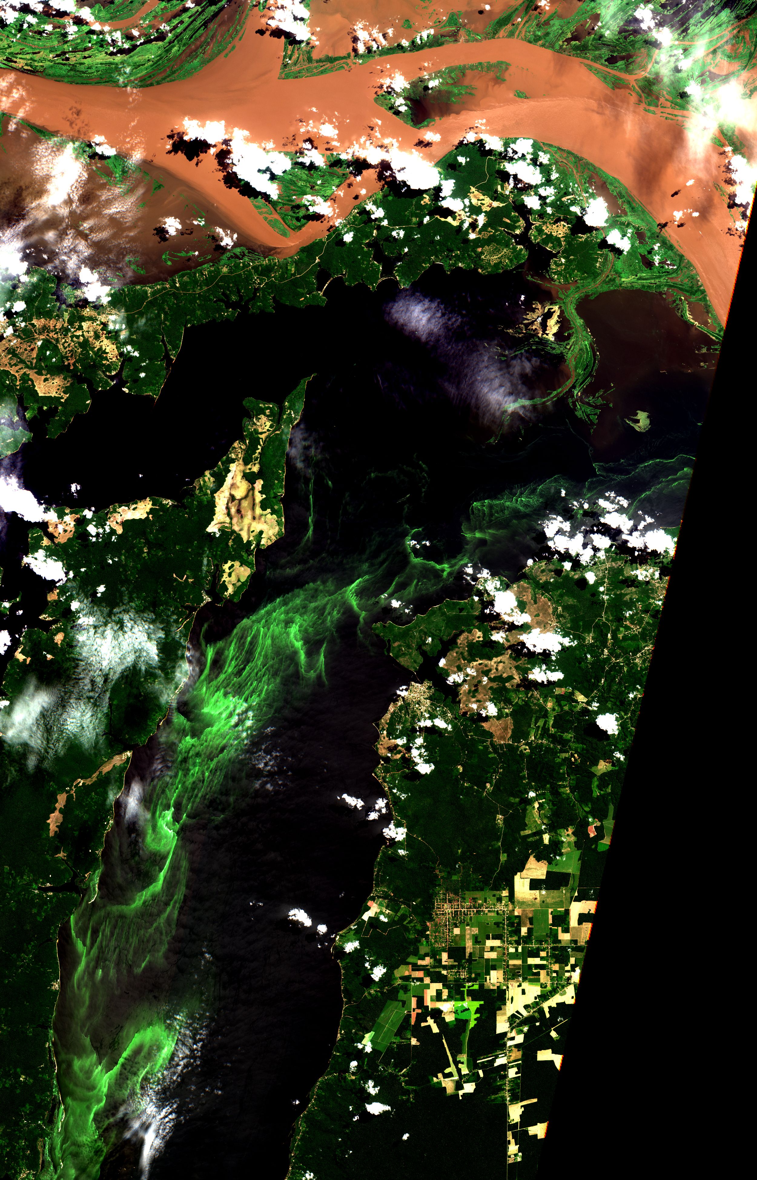
English: Florações no Rio Tapajós. Pesquisa do pós-doc Felipe Lobo (Estudo espaço-temporal de florações de cianobactérias no Rio Tapajós: Experimento em laboratório e monitoramento por sensoriamento remoto) / Bloom at Tapajós River. Post-doc research Felipe Lobo (Space-time study of cyanobacterial blooms in the Tapajós River: Experiment in the laboratory and monitoring by remote sensing) (CNPQ).
Felipe relata: "O objetivo é investigar a ocorrência de florações de cianobactérias no Rio Tapajós ao longo de dois anos (2015-2017) com imagens de satélite Sentinel-2A. Resultados preliminares indicam que as florações são mais frequentes durantes os períodos de enchente e cheia quando a água do rio fica mais parada, e diminuem durante a vazante. As florações são um indicativo que o rio Tapajós passa por um processo de eutrofização (ainda que em estágios iniciais), provavelmente, por uma combinação de fatores como o próprio aquecimento global, que favorece o crescimento de fitoplâncton, e também enriquecimento por nutrientes provenientes de atividades humanas no entorno e nas cabeceiras do rio Tapajós, onde intensa atividade garimpeira despeja anualmente toneladas de sedimento aos rios. Os próximos passos dessa pesquisa visam implementar um monitoramento dessas florações com imagens de satélite para confirmar ou não o aumento da frequência e/ou extensão dessas florações ao longo dos anos e, principalmente, a influência das atividades humanas." / Felipe reports: "The objective is to investigate the occurrence of cyanobacteria blooms in the Tapajós River over two years (2015-2017) with images of satellite Sentinel-2A. Preliminary results indicate flowering is more frequent during flood and full periods when river water becomes more stationary, and decrease during the ebb. Bloom is an indication Tapajós River undergoes a process of eutrophication (albeit in the early stages), probably because of a combination of factors such as global warming itself, which phytoplankton growth, as well as nutrient enrichment from human activities in headwaters of the Tapajós river, where intense mining activity annually dumps tons of sediment to the rivers. The next steps aim to implement a monitoring of these blooms with satellite images to confirm or not to increase the frequency and / or extent of these blooms over the years and, mainly, the influence of human activities. "
Imagem / Image Sentinel-2A Rio Tapajós Coordenadas do centro da imagem/ Center Image: 2º30' S e 55º01' W Data / Date: 09-06-2017 / 2017-09-06 RGB 432 (cor verdadeira / true color) Cena / Scene: T21MYT Autor / Author: Felipe Lobo (Pós-doc em Sensoriamento Remoto - INPE) Imagem em HD / HD Image Visite-nos / Visit us: www.dsr.inpe.br |
| Date | |
| Source | https://www.flickr.com/photos/153282474@N02/29026051718/ |
| Author | Coordenação-Geral de Observação da Terra/INPE |
Licensing
[edit]
- You are free:
- to share – to copy, distribute and transmit the work
- to remix – to adapt the work
- Under the following conditions:
- attribution – You must give appropriate credit, provide a link to the license, and indicate if changes were made. You may do so in any reasonable manner, but not in any way that suggests the licensor endorses you or your use.
- share alike – If you remix, transform, or build upon the material, you must distribute your contributions under the same or compatible license as the original.
| This image was originally posted to Flickr by Coordenação-Geral de Observação da Terra/INPE at https://flickr.com/photos/153282474@N02/29026051718. It was reviewed on 9 April 2020 by FlickreviewR 2 and was confirmed to be licensed under the terms of the cc-by-sa-2.0. |
File history
Click on a date/time to view the file as it appeared at that time.
| Date/Time | Thumbnail | Dimensions | User | Comment | |
|---|---|---|---|---|---|
| current | 10:14, 9 April 2020 | | 2,500 × 3,900 (1.81 MB) | Jo-Jo Eumerus (talk | contribs) | Uploaded a work by Coordenação-Geral de Observação da Terra/INPE from https://www.flickr.com/photos/153282474@N02/29026051718/ with UploadWizard |
You cannot overwrite this file.
File usage on Commons
The following page uses this file:
.jpg&redirect=no)