File:Bloody Angle Elm Brook Hill, part 3 (80a68d9e-4d63-47d3-8f02-14192e6fb6ce).jpg
Jump to navigation
Jump to search
Size of this preview: 800 × 400 pixels. Other resolutions: 320 × 160 pixels | 640 × 320 pixels | 1,024 × 512 pixels | 1,280 × 640 pixels | 2,560 × 1,280 pixels | 5,376 × 2,688 pixels.
Original file (5,376 × 2,688 pixels, file size: 5.25 MB, MIME type: image/jpeg)
Captions
Captions
Add a one-line explanation of what this file represents
| Camera location | | View this and other nearby images on: OpenStreetMap |
|---|
.jpg¶ms=042.455336_N_-071.298322_E_globe:Earth_type:camera_alt:65.52_source:exif_heading:97.65&language=en)

|
The categories of this image need checking. You can do so here.
|
.jpg&action=edit&withJS=MediaWiki:Catcheck.js)
Summary
[edit].jpg&action=edit§ion=1)
| English: Bloody Angle / Elm Brook Hill, part 3 | ||||
|---|---|---|---|---|
| Photographer |
English: NPS photo |
|||
| Title |
English: Bloody Angle / Elm Brook Hill, part 3 |
|||
| Description |
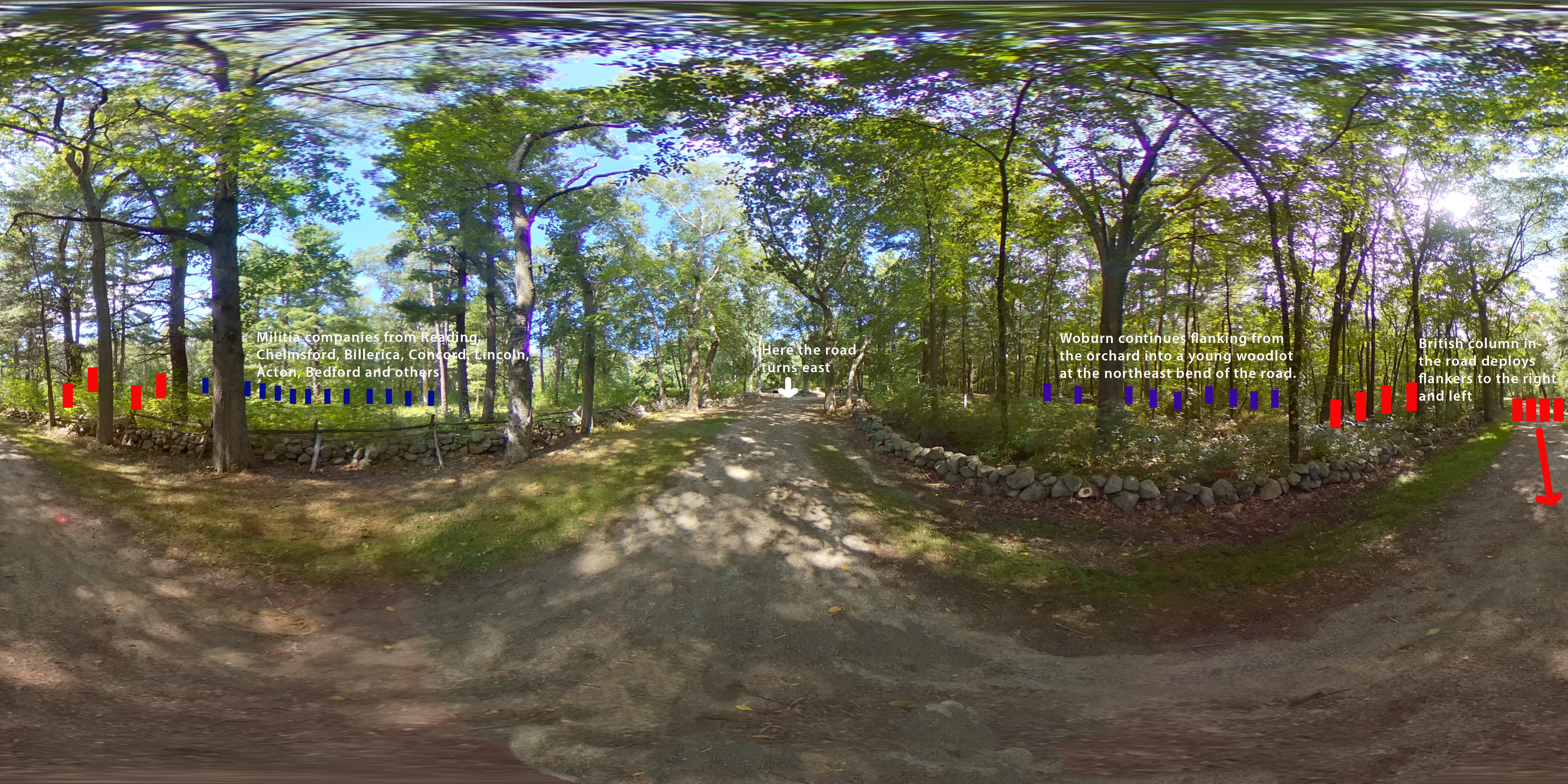
English: A historic dirt roadway with stone walls and woods on both sides. Enhancements of text, colored rectangles and arrows indicate troop movements. This image shows the part of the road where the British column, under attack from the Woburn Militia is also attacked on their left by companies from other towns.
|
|||
| Depicted place |
English: Latitude: 42.4553361111111, Longitude: -71.2983222222222, Elevation: 65.52; Minute Man National Historical Park, Middlesex County, Massachusetts; Latitude: 42.4533996582031, Longitude: -71.2959976196289 |
|||
| Date | Taken on 11 September 2020 | |||
| Accession number | ||||
| Source |
English: NPGallery |
|||
| Permission (Reusing this file) |
|
|||
| NPS Unit Code | MIMA | |||
| Album(s) | English: 360 Panoramas |
|||
File history
Click on a date/time to view the file as it appeared at that time.
| Date/Time | Thumbnail | Dimensions | User | Comment | |
|---|---|---|---|---|---|
| current | 09:24, 23 May 2021 | | 5,376 × 2,688 (5.25 MB) | BMacZeroBot (talk | contribs) | Batch upload (Commons:Batch uploading/NPGallery) |
You cannot overwrite this file.
File usage on Commons
The following page uses this file:
.jpg)
.jpg&oldid=826617342)