File:Bletchley railway station 1833441 f81b42a2.jpg
Jump to navigation
Jump to search

Size of this preview: 800 × 449 pixels. Other resolutions: 320 × 179 pixels | 640 × 359 pixels | 1,024 × 574 pixels | 1,280 × 718 pixels | 2,390 × 1,340 pixels.
Original file (2,390 × 1,340 pixels, file size: 664 KB, MIME type: image/jpeg)
Captions
Captions
Add a one-line explanation of what this file represents
Summary
[edit]| Description |
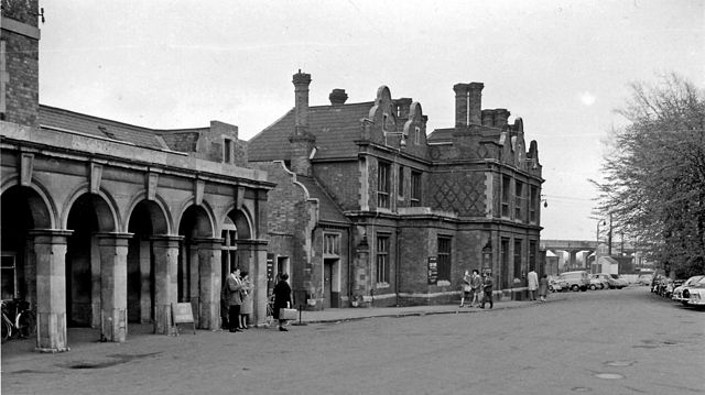
English: Bletchley Station, exterior.
View southward, towards London (and Oxford); ex-LNW London - Rugby - Birmingham and the North WCML, junction for Oxford, Bedford and Cambridge. This was entrance of station, on the Down side before the station was completely rebuilt in 1965 for the WCML electrification. The post-war flyover, connecting with Oxford line - but scarcely used - is visible in the background. Passengers services to Oxford, and Bedford - Cambridge ceased 1/1/68, but were restored Oxford - Bicester on 9/5/87 and may well soon return to Bletchley. |
||
| Date | |||
| Source | From geograph.org.uk | ||
| Author | Ben Brooksbank | ||
| Permission (Reusing this file) |
This file is licensed under the Creative Commons Attribution-Share Alike 2.0 Generic license. Attribution: Ben Brooksbank
|

| Camera location | | View this and other nearby images on: OpenStreetMap |
|---|
File history
Click on a date/time to view the file as it appeared at that time.
| Date/Time | Thumbnail | Dimensions | User | Comment | |
|---|---|---|---|---|---|
| current | 14:47, 21 January 2014 | | 2,390 × 1,340 (664 KB) | Chevin (talk | contribs) | Larger version |
| 13:54, 25 May 2010 |  | 640 × 338 (96 KB) | Chevin (talk | contribs) | == {{int:filedesc}} == {{Information |Description={{en|1=Bletchley Station, exterior}} View southward, towards London (and Oxford); ex-LNW London - Rugby - Birmingham and the North WCML, junction for Oxford, Bedford and Cambridge. This was entrance of sta |
You cannot overwrite this file.
File usage on Commons
The following 2 pages use this file:
File usage on other wikis
The following other wikis use this file:
- Usage on ar.wikipedia.org
- Usage on arz.wikipedia.org
- Usage on de.wikipedia.org
- Usage on en.wikipedia.org
- Usage on en.wikivoyage.org
- Usage on nl.wikipedia.org
- Usage on www.wikidata.org