File:Blennerville - geograph.org.uk - 248079.jpg
Jump to navigation
Jump to search
No higher resolution available.
Blennerville_-_geograph.org.uk_-_248079.jpg (640 × 480 pixels, file size: 50 KB, MIME type: image/jpeg)
Captions
Captions
Add a one-line explanation of what this file represents
Summary
[edit]
| Description |
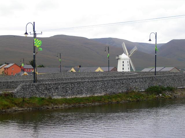
English: Blennerville. The windmill was built in 1800. It was repaired and redeveloped as a working mill in 1981, but the sails were incomplete when I went. Not sure of exact grid square. I believe there is a light railway nearby. The mountains in the background are the Slieve Mish Mountains. The distinctive green and yellow flags - which were everywhere in Kerry - are connected with the Gaelic football final (I think). |
| Date | |
| Source | From geograph.org.uk |
| Author | Peter Craine |
| Attribution (required by the license) | Peter Craine / Blennerville / |
| Object location | | View this and other nearby images on: OpenStreetMap |
|---|
_&language=en)
Licensing
[edit]

|
This image was taken from the Geograph project collection. See this photograph's page on the Geograph website for the photographer's contact details. The copyright on this image is owned by Peter Craine and is licensed for reuse under the Creative Commons Attribution-ShareAlike 2.0 license.
|
This file is licensed under the Creative Commons Attribution-Share Alike 2.0 Generic license.
Attribution: Peter Craine
- You are free:
- to share – to copy, distribute and transmit the work
- to remix – to adapt the work
- Under the following conditions:
- attribution – You must give appropriate credit, provide a link to the license, and indicate if changes were made. You may do so in any reasonable manner, but not in any way that suggests the licensor endorses you or your use.
- share alike – If you remix, transform, or build upon the material, you must distribute your contributions under the same or compatible license as the original.
File history
Click on a date/time to view the file as it appeared at that time.
| Date/Time | Thumbnail | Dimensions | User | Comment | |
|---|---|---|---|---|---|
| current | 22:34, 31 January 2010 | | 640 × 480 (50 KB) | GeographBot (talk | contribs) | == {{int:filedesc}} == {{Information |description={{en|1=Blennerville. The windmill was built in 1800. It was repaired and redeveloped as a working mill in 1981, but the sails were incomplete when I went. Not sure of exact grid square. I believe there is |
You cannot overwrite this file.
File usage on Commons
There are no pages that use this file.