File:Blauspitze.jpg
Jump to navigation
Jump to search

Size of this preview: 800 × 450 pixels. Other resolutions: 320 × 180 pixels | 640 × 360 pixels | 1,024 × 576 pixels | 1,280 × 720 pixels | 2,560 × 1,440 pixels | 6,016 × 3,384 pixels.
Original file (6,016 × 3,384 pixels, file size: 5.55 MB, MIME type: image/jpeg)
Captions
Captions
Add a one-line explanation of what this file represents
Summary
[edit]
![]() Austria
Austria ![]() Land Tirol - Granatspitzgruppe 2.575 mü.A.
Land Tirol - Granatspitzgruppe 2.575 mü.A.
| Description |
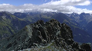
Deutsch: Vom höchsten Punkt (~2.590 m) der Blauspitze in der Granatspitzgruppe schauen wir über das Gipfelkreuz nach Osten bis Südosten in die Glockner- und Schobergruppe. |
| Date | Taken on 22 August 2016, 12:03:47 |
| Source | Own work |
| Author | FkMohr |
| Camera location | | View this and other nearby images on: OpenStreetMap |
|---|
OT {XP160822-1203} übertragen von Panoramio (User Mohr=1080936, Bild 133437223).
Licensing
[edit]
Friedrich-Karl Mohr, the copyright holder of this work, hereby publishes it under the following license:
This file is licensed under the Creative Commons Attribution-Share Alike 3.0 Germany license.
Attribution: Friedrich-Karl Mohr
- You are free:
- to share – to copy, distribute and transmit the work
- to remix – to adapt the work
- Under the following conditions:
- attribution – You must give appropriate credit, provide a link to the license, and indicate if changes were made. You may do so in any reasonable manner, but not in any way that suggests the licensor endorses you or your use.
- share alike – If you remix, transform, or build upon the material, you must distribute your contributions under the same or compatible license as the original.

| Annotations | This image is annotated: View the annotations at Commons |
File history
Click on a date/time to view the file as it appeared at that time.
| Date/Time | Thumbnail | Dimensions | User | Comment | |
|---|---|---|---|---|---|
| current | 14:38, 24 June 2017 | | 6,016 × 3,384 (5.55 MB) | FkMohr (talk | contribs) | Transferred from http://static.panoramio.com/photos/original/133437223.jpg |
You cannot overwrite this file.
File usage on Commons
There are no pages that use this file.
File usage on other wikis
The following other wikis use this file:
- Usage on de.wikipedia.org