File:Blanefield rainbow geograph-3203890-by-Ben-Brooksbank.jpg
Jump to navigation
Jump to search

Size of this preview: 800 × 435 pixels. Other resolutions: 320 × 174 pixels | 640 × 348 pixels | 925 × 503 pixels.
Original file (925 × 503 pixels, file size: 549 KB, MIME type: image/jpeg)
Captions
Captions
Add a one-line explanation of what this file represents
Summary
[edit]
| Description |
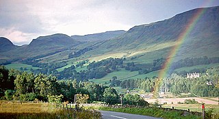
English: Rainbow in Strathblane at Blanefield. View NW up the Strath from near the former railway station - see NS5479 :Blanefield Station 1831254 92e15256.jpg |
| Date | |
| Source | From geograph.org.uk |
| Author | Ben Brooksbank |
| Permission (Reusing this file) |
Creative Commons Attribution Share-alike license 2.0 |
| Attribution (required by the license) | Ben Brooksbank / Rainbow in Strathblane at Blanefield / |
| Camera location | | View this and other nearby images on: OpenStreetMap |
|---|
Licensing
[edit]

|
This image was taken from the Geograph project collection. See this photograph's page on the Geograph website for the photographer's contact details. The copyright on this image is owned by Ben Brooksbank and is licensed for reuse under the Creative Commons Attribution-ShareAlike 2.0 license.
|
This file is licensed under the Creative Commons Attribution-Share Alike 2.0 Generic license.
Attribution: Ben Brooksbank
- You are free:
- to share – to copy, distribute and transmit the work
- to remix – to adapt the work
- Under the following conditions:
- attribution – You must give appropriate credit, provide a link to the license, and indicate if changes were made. You may do so in any reasonable manner, but not in any way that suggests the licensor endorses you or your use.
- share alike – If you remix, transform, or build upon the material, you must distribute your contributions under the same or compatible license as the original.
File history
Click on a date/time to view the file as it appeared at that time.
| Date/Time | Thumbnail | Dimensions | User | Comment | |
|---|---|---|---|---|---|
| current | 21:32, 18 November 2012 | | 925 × 503 (549 KB) | Chevin (talk | contribs) | == {{int:filedesc}} == {{Information |Description={{en|1='''Rainbow in Strathblane at Blanefield.'''<br/> View NW up the Strath from near the former railway station - see NS5479 :Blanefield Station 1831254 92e15256.jpg.}} |Source=From [http://www.g... |
You cannot overwrite this file.
File usage on Commons
There are no pages that use this file.