File:Blakey 020Ma - COL.jpg
Jump to navigation
Jump to search
No higher resolution available.
Blakey_020Ma_-_COL.jpg (254 × 189 pixels, file size: 38 KB, MIME type: image/jpeg)
Captions
Captions
Add a one-line explanation of what this file represents
Summary
[edit]
| Description |
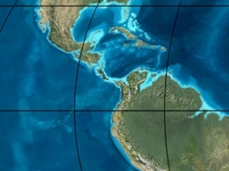
English: Paleogeography Colombia 20 Ma |
| Date | |
| Source | Adaptations (cutouts) of https://commons.wikimedia.org/wiki/Category:Maps_by_Ron_Blakey |
| Author | Xibalba |
Licensing
[edit]
This file is licensed under the Creative Commons Attribution-Share Alike 3.0 Unported license.
- You are free:
- to share – to copy, distribute and transmit the work
- to remix – to adapt the work
- Under the following conditions:
- attribution – You must give appropriate credit, provide a link to the license, and indicate if changes were made. You may do so in any reasonable manner, but not in any way that suggests the licensor endorses you or your use.
- share alike – If you remix, transform, or build upon the material, you must distribute your contributions under the same or compatible license as the original.
File history
Click on a date/time to view the file as it appeared at that time.
| Date/Time | Thumbnail | Dimensions | User | Comment | |
|---|---|---|---|---|---|
| current | 07:07, 13 November 2013 | | 254 × 189 (38 KB) | XibalbaWikiCommons (talk | contribs) | User created page with UploadWizard |
You cannot overwrite this file.
File usage on Commons
There are no pages that use this file.
File usage on other wikis
The following other wikis use this file:
- Usage on en.wikipedia.org
- Castillo Formation, Venezuela
- La Quinta Formation
- Paja Formation
- User:Tisquesusa/sandbox7
- Eastern Hills (Bogotá)
- Marichuela Formation
- Chipaque Formation
- Guadalupe Group
- Subachoque Formation
- Guaduas Formation
- Bogotá Formation
- Usme Formation
- Regadera Formation
- Floresta Formation
- Sabana Formation
- Soatá Formation
- Arcabuco Formation
- Honda Group, Colombia
- Cuche Formation
- Cesar-Ranchería Basin
- Las Juntas Formation
- Macanal Formation
- Cocinetas Basin
- Río Cachirí Group
- Barzalosa Formation
- Fómeque Formation
- Une Formation
- Rosablanca Formation
- Romeral Fault System
- Loma Gorda Formation
- Caballos Formation
- Venado Formation
- Template:Stratigraphy of the Llanos Basin
- Llanos Basin
- Santa Teresa Formation, Colombia
- Noreán Formation
- Usage on es.wikipedia.org
- Usage on nl.wikipedia.org
- Usage on zh.wikibooks.org