File:Blake River Megacaldera Complex map.jpg
Jump to navigation
Jump to search

Size of this preview: 800 × 478 pixels. Other resolutions: 320 × 191 pixels | 640 × 382 pixels | 906 × 541 pixels.
Original file (906 × 541 pixels, file size: 229 KB, MIME type: image/jpeg)
Captions
Captions
Add a one-line explanation of what this file represents
Summary
[edit]
| Description |
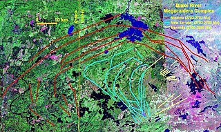
English: Map of the Blake River Megacaldera Complex. |
| Date | |
| Source | NASA World Wind |
| Author | NASA/Black Tusk |
| Permission (Reusing this file) |
NASA, public domain |
Licensing
[edit]
| This image is in the public domain because it is a screenshot from NASA’s globe software World Wind using a public domain layer, such as Blue Marble, MODIS, Landsat, SRTM, USGS or GLOBE.
|
 |
File history
Click on a date/time to view the file as it appeared at that time.
| Date/Time | Thumbnail | Dimensions | User | Comment | |
|---|---|---|---|---|---|
| current | 01:22, 14 October 2008 | | 906 × 541 (229 KB) | Black Tusk (talk | contribs) | {{Information |Description={{en|1=Map of the Blake River Megacaldera Complex.}} |Source=NASA World Wind |Author=NASA/Black Tusk |Date=October 13, 2008 |Permission=NASA, public domain |other_versions= }} <!--{{ImageUpload|full}}--> |
You cannot overwrite this file.
File usage on Commons
There are no pages that use this file.
File usage on other wikis
The following other wikis use this file:
- Usage on ar.wikipedia.org
- Usage on arz.wikipedia.org
- Usage on en.wikipedia.org
- Usage on es.wikipedia.org
- Usage on lld.wikipedia.org
- Usage on nl.wikipedia.org
- Usage on uk.wikipedia.org
- Usage on www.wikidata.org