File:Blake Hall station, near Ongar (geograph 6241574).jpg
Jump to navigation
Jump to search

Size of this preview: 800 × 600 pixels. Other resolutions: 320 × 240 pixels | 640 × 480 pixels | 1,024 × 768 pixels.
Original file (1,024 × 768 pixels, file size: 247 KB, MIME type: image/jpeg)
Captions
Captions
Add a one-line explanation of what this file represents
Summary
[edit].jpg&action=edit§ion=1)
| Description |
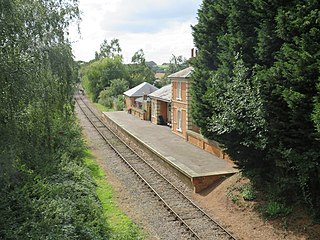
English: Blake Hall station, near Ongar Blake Hall station was opened in 1865, on the railway line linking Epping with Ongar. The station was built as part of an agreement with a landowner, so that the railway line could be built across his land. The station is about a mile from Blake Hall itself, and in a rural part of Essex. The railway line and station passed to London Underground in 1949 and became part of the Central Line. Blake Hall station closed in 1981, and London Underground closed the railway from Epping to Ongar in 1994. However the line has since reopened as a heritage railway. Although part of the station platform has been restored, trains do not stop at Blake Hall. The former station building is now a private residence. |
| Date | |
| Source | From geograph.org.uk |
| Author | Malc McDonald |
| Permission (Reusing this file) |
Creative Commons Attribution Share-alike license 2.0 |
| Attribution (required by the license) | Malc McDonald / Blake Hall station, near Ongar / |
| Camera location | | View this and other nearby images on: OpenStreetMap |
|---|
.jpg¶ms=051.712075_N_0000.203463_E_globe:Earth_type:camera_source:geograph-osgb36(TL52330378)_heading:270.00&language=en)
| Object location | | View this and other nearby images on: OpenStreetMap |
|---|
.jpg¶ms=051.712080_N_0000.203170_E_globe:Earth_class:object_type:object_source:geograph-osgb36(TL52310378)_heading:270.00&language=en)
Licensing
[edit].jpg&action=edit§ion=2)

|
This image was taken from the Geograph project collection. See this photograph's page on the Geograph website for the photographer's contact details. The copyright on this image is owned by Malc McDonald and is licensed for reuse under the Creative Commons Attribution-ShareAlike 2.0 license.
|
This file is licensed under the Creative Commons Attribution-Share Alike 2.0 Generic license.
Attribution: Malc McDonald
- You are free:
- to share – to copy, distribute and transmit the work
- to remix – to adapt the work
- Under the following conditions:
- attribution – You must give appropriate credit, provide a link to the license, and indicate if changes were made. You may do so in any reasonable manner, but not in any way that suggests the licensor endorses you or your use.
- share alike – If you remix, transform, or build upon the material, you must distribute your contributions under the same or compatible license as the original.
File history
Click on a date/time to view the file as it appeared at that time.
| Date/Time | Thumbnail | Dimensions | User | Comment | |
|---|---|---|---|---|---|
| current | 16:39, 31 October 2020 | | 1,024 × 768 (247 KB) | Lamberhurst (talk | contribs) | Transferred from geograph.co.uk using [https://tools.wmflabs.org/geograph2commons/ geograph2commons] |
You cannot overwrite this file.
File usage on Commons
The following page uses this file:
File usage on other wikis
The following other wikis use this file:
- Usage on nl.wikipedia.org
.jpg&oldid=825270221)