File:Blacks And Whites Take To The Water At A 12th Street Beach On Lake Michigan On Chicago's South Side, 08-1973 (8675941948).jpg

Original file (3,000 × 2,034 pixels, file size: 420 KB, MIME type: image/jpeg)
Captions
Captions
Summary
[edit].jpg&action=edit§ion=1)
| Description |
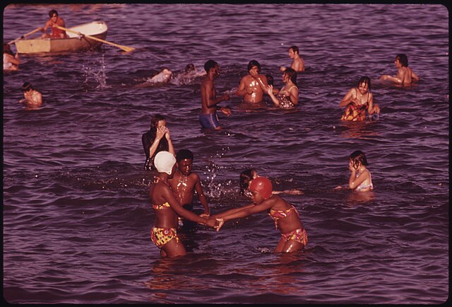
Original Caption: Blacks And Whites Take To The Water At A 12th Street Beach On Lake Michigan On Chicago's South Side In The Summer Of 1973. From 1960 To 1970 The Percentage Of Chicago Blacks With An Income Of $7,000 Or More Jumped From 26 To 58%. Median Black Income During The Period Increased From $4,700 To $7,883, But The Dollar Gap Between Their Group And The Whites Actually Widened. Chicago Has 29 Miles Of Lakefront And 30 Public Beaches, 08/1973 U.S. National Archives’ Local Identifier: 412-DA-13843 Photographer: White, John H, 1945- Subjects: African-American Chicago (Cook county, Illinois, United States) Environmental Protection Agency Project DOCUMERICA Persistent URL: arcweb.archives.gov/arc/action/ExternalIdSearch?id=556295 Repository: Still Picture Records Section, Special Media Archives Services Division (NWCS-S), National Archives at College Park, 8601 Adelphi Road, College Park, MD, 20740-6001. For information about ordering reproductions of photographs held by the Still Picture Unit, visit: www.archives.gov/research/order/still-pictures.html Reproductions may be ordered via an independent vendor. NARA maintains a list of vendors at www.archives.gov/research/order/vendors-photos-maps-dc.html Access Restrictions: Unrestricted Use Restrictions: Unrestricted |
|||
| Date | Taken in August 1973 | |||
| Source |
|
|||
| Author | The U.S. National Archives | |||
| Permission (Reusing this file) |
The U.S. National Archives @ Flickr Commons |
| Camera location | | View this and other nearby images on: OpenStreetMap |
|---|
.jpg¶ms=041.884151_N_-087.632408_E_globe:Earth_type:camera_source:Flickr_&language=en)
Licensing
[edit].jpg&action=edit§ion=2)
This image was taken from Flickr's The Commons. The uploading organization may have various reasons for determining that no known copyright restrictions exist, such as:
More information can be found at https://flickr.com/commons/usage/. Please add additional copyright tags to this image if more specific information about copyright status can be determined. See Commons:Licensing for more information. |
| This image was originally posted to Flickr by The U.S. National Archives at https://flickr.com/photos/35740357@N03/8675941948 (archive). It was reviewed on 11 January 2018 by FlickreviewR 2 and was confirmed to be licensed under the terms of the No known copyright restrictions. |
This image (or other media) is a work of an Environmental Protection Agency employee, taken or made as part of that person's official duties. As works of the U.S. federal government, all EPA images are in the public domain.
|
||
File history
Click on a date/time to view the file as it appeared at that time.
| Date/Time | Thumbnail | Dimensions | User | Comment | |
|---|---|---|---|---|---|
| current | 19:06, 11 January 2018 | | 3,000 × 2,034 (420 KB) | Artix Kreiger 2 (talk | contribs) | Transferred from Flickr via Flickr2Commons |
You cannot overwrite this file.
File usage on Commons
There are no pages that use this file.
.jpg&oldid=915850259)