File:Black Hawk Bridge Lansing 1995.jpg
Jump to navigation
Jump to search

Size of this preview: 762 × 600 pixels. Other resolutions: 305 × 240 pixels | 610 × 480 pixels | 976 × 768 pixels | 1,280 × 1,007 pixels | 2,560 × 2,015 pixels | 4,623 × 3,638 pixels.
Original file (4,623 × 3,638 pixels, file size: 3.09 MB, MIME type: image/jpeg)
Captions
Captions
Add a one-line explanation of what this file represents
| Description |
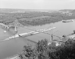
English: Aerial photo of the Black Hawk Bridge — on the Mississippi River in Lansing, Iowa.
Note found on caption page |
|||||
| Date | Summer 1995 | |||||
| Source |
|
|||||
| Author | Joe Elliott (photographer) | |||||
| Permission (Reusing this file) |
|


| Camera location | | View this and other nearby images on: OpenStreetMap |
|---|
File history
Click on a date/time to view the file as it appeared at that time.
| Date/Time | Thumbnail | Dimensions | User | Comment | |
|---|---|---|---|---|---|
| current | 23:45, 15 August 2011 | | 4,623 × 3,638 (3.09 MB) | Ras67 (talk | contribs) | {{Information |Description ={{en|1=Black Hawk Bridge, Lansing, 1995 This image was found at the Library of Congress HAER archive entry with the original caption: "1. 3/4 VIEW FROM TOP OF BLUFF, FROM NORT |
You cannot overwrite this file.
File usage on Commons
The following page uses this file:
File usage on other wikis
The following other wikis use this file:
- Usage on it.wikipedia.org
- Usage on pms.wikipedia.org