File:Bjorøy Tunnel map 2.svg
Jump to navigation
Jump to search

Size of this PNG preview of this SVG file: 311 × 349 pixels. Other resolutions: 214 × 240 pixels | 428 × 480 pixels | 684 × 768 pixels | 912 × 1,024 pixels | 1,825 × 2,048 pixels.
Original file (SVG file, nominally 311 × 349 pixels, file size: 287 KB)
Captions
Captions
Add a one-line explanation of what this file represents
Summary
[edit]
| Description |
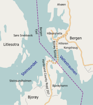
English: Map showing the Bjorøy Tunnel, the immediate surrounding areas and places relevant for the article. Some of the data gathered from OpenStreetMaps. |
| Date | |
| Source | Own work |
| Author | Alasdair McLellan |
Licensing
[edit]
I, the copyright holder of this work, hereby publish it under the following license:
This file is licensed under the Creative Commons Attribution-Share Alike 3.0 Unported license.
- You are free:
- to share – to copy, distribute and transmit the work
- to remix – to adapt the work
- Under the following conditions:
- attribution – You must give appropriate credit, provide a link to the license, and indicate if changes were made. You may do so in any reasonable manner, but not in any way that suggests the licensor endorses you or your use.
- share alike – If you remix, transform, or build upon the material, you must distribute your contributions under the same or compatible license as the original.
File history
Click on a date/time to view the file as it appeared at that time.
| Date/Time | Thumbnail | Dimensions | User | Comment | |
|---|---|---|---|---|---|
| current | 18:55, 8 March 2011 | | 311 × 349 (287 KB) | Arsenikk (talk | contribs) | Added a few new names |
| 18:42, 8 March 2011 |  | 311 × 349 (286 KB) | Arsenikk (talk | contribs) | {{Information |Description ={{en|1=Map showing the Bjorøy Tunnel, the immediate surrounding areas and places relevant for the article. Some of the data gathered from OpenStreetMaps.}} |Source ={{own}} |Author =[[User:Arsenikk|Alasdair |
You cannot overwrite this file.
File usage on Commons
There are no pages that use this file.
File usage on other wikis
The following other wikis use this file:
- Usage on en.wikipedia.org
- Usage on no.wikipedia.org