File:Bjørnøya Location Map-da.svg
Jump to navigation
Jump to search

Size of this PNG preview of this SVG file: 478 × 600 pixels. Other resolutions: 191 × 240 pixels | 383 × 480 pixels | 612 × 768 pixels | 816 × 1,024 pixels | 1,632 × 2,048 pixels | 1,010 × 1,267 pixels.
Original file (SVG file, nominally 1,010 × 1,267 pixels, file size: 240 KB)
Captions
Captions
Add a one-line explanation of what this file represents
Summary
[edit]| Description |
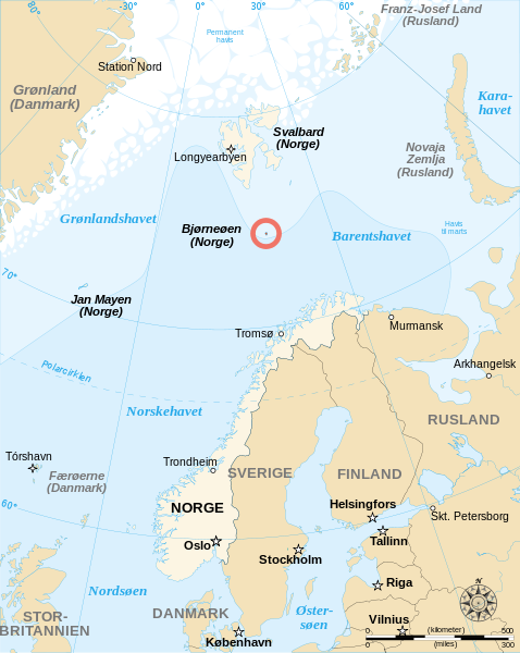
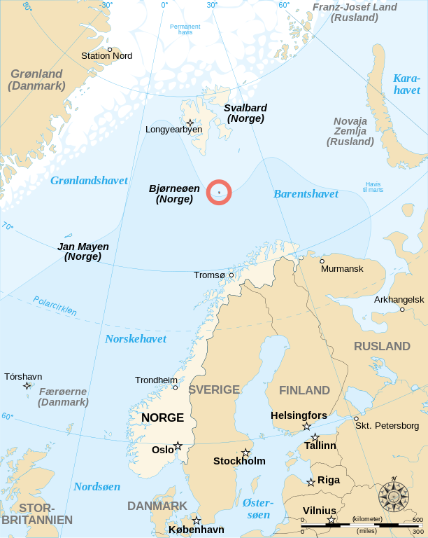
Dansk: Dansksproget kort visende Bjørneøens (Bjørnøyas) position i Norskehavet. Kortet adskiller sig fra originalen ved at jeg har tilføjet en markering af den litauiske hovedstad Vilnius som ikke var angivet på det oprindelige kort.
English: Danish-language map showing the location of Bjørnøya (Bear Island), an island between Norway and Svalbard. I've added a locator for Vilnius (Lithuania) which was missing on the original map. |
| Date | |
| Source | Image:Bjornoya Location Map-en.svg and |
| Author | Sémhur (translation by Valentinian. Based on the bokmål translation by Jon Harald Søby) |
| Permission (Reusing this file) |
CC-by-SA & GFDL |
| Other versions |
[]
|


Licensing
[edit]
Sémhur, the copyright holder of this work, hereby publishes it under the following licenses:

|
Permission is granted to copy, distribute and/or modify this document under the terms of the GNU Free Documentation License, Version 1.2 or any later version published by the Free Software Foundation; with no Invariant Sections, no Front-Cover Texts, and no Back-Cover Texts. A copy of the license is included in the section entitled GNU Free Documentation License. |
This file is licensed under the Creative Commons Attribution-Share Alike 3.0 Unported, 2.5 Generic, 2.0 Generic and 1.0 Generic license.
Attribution: Sémhur
- You are free:
- to share – to copy, distribute and transmit the work
- to remix – to adapt the work
- Under the following conditions:
- attribution – You must give appropriate credit, provide a link to the license, and indicate if changes were made. You may do so in any reasonable manner, but not in any way that suggests the licensor endorses you or your use.
- share alike – If you remix, transform, or build upon the material, you must distribute your contributions under the same or compatible license as the original.
You may select the license of your choice.
| Camera location | | View this and other nearby images on: OpenStreetMap |
|---|

|
This SVG file contains embedded text that can be translated into your language, using any capable SVG editor, text editor or the SVG Translate tool. For more information see: About translating SVG files. |
This W3C-unspecified vector image was created with Inkscape .
File history
Click on a date/time to view the file as it appeared at that time.
| Date/Time | Thumbnail | Dimensions | User | Comment | |
|---|---|---|---|---|---|
| current | 11:33, 26 March 2008 | | 1,010 × 1,267 (240 KB) | Valentinian (talk | contribs) | Minor fix: "Nord" -> "Station Nord" |
| 21:59, 25 March 2008 |  | 1,010 × 1,267 (240 KB) | Valentinian (talk | contribs) | {{Information |Description={{da|Dansksproget kort visende Bjørneøens (Bjørnøyas) position i Norskehavet. Kortet adskiller sig fra originalen ved at jeg har tilføjet en markering af den litauiske hovedstad Vilnius manglede på det oprindelige kort.}} |
You cannot overwrite this file.
File usage on Commons
The following 8 pages use this file:
File usage on other wikis
The following other wikis use this file:
- Usage on da.wikipedia.org