File:BitwaOFortCarillon.jpg
Jump to navigation
Jump to search
Size of this preview: 766 × 599 pixels. Other resolutions: 307 × 240 pixels | 614 × 480 pixels | 982 × 768 pixels | 1,280 × 1,002 pixels | 2,083 × 1,630 pixels.
Original file (2,083 × 1,630 pixels, file size: 702 KB, MIME type: image/jpeg)
Captions
Captions
Add a one-line explanation of what this file represents
| Description |
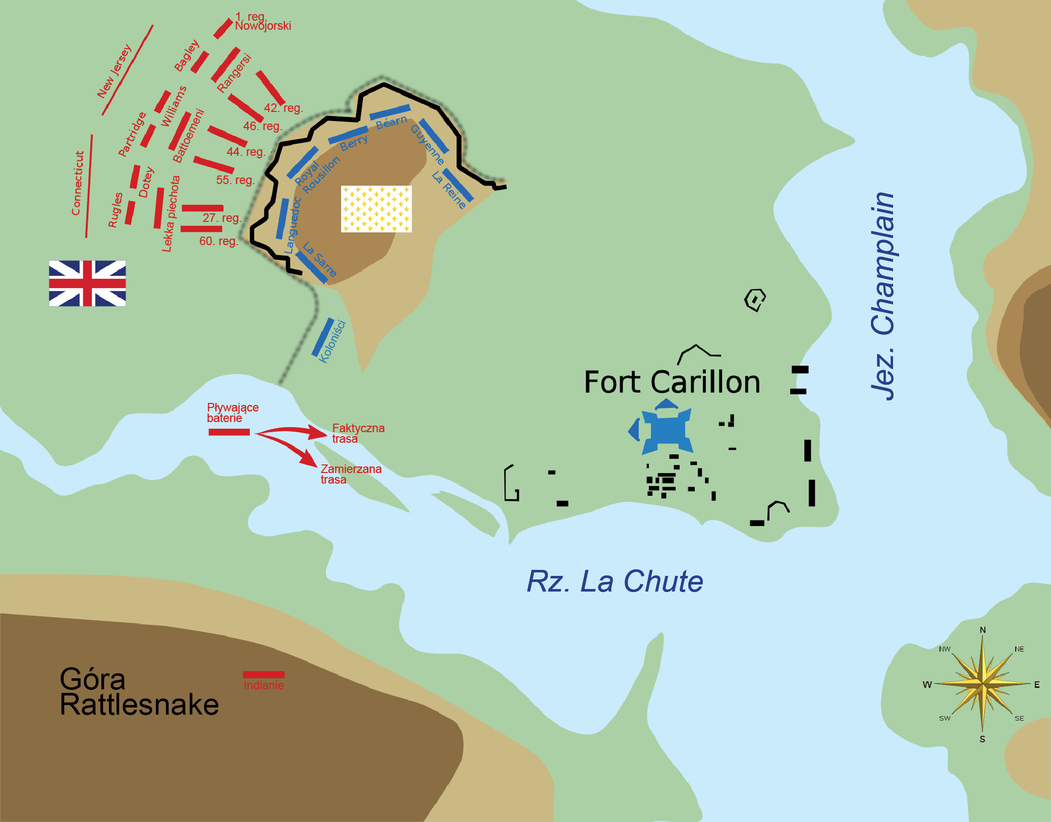
Polski: Bitwa o Fort Carillon z wyszczególnionymi pozycjami brytyjskimi i francuskimi English: A schematic representation of the 1758 map by Thomas Jeffreys (File:TiconderogaJeffreys1758.jpg), including rough terrain elevations and military positions of the Battle of Carillon. |
| Date | (UTC) |
| Source | |
| Author |
|
| This is a retouched picture, which means that it has been digitally altered from its original version. Modifications: Polish labels. The original can be viewed here: CarillonBattle.svg:
|
I, the copyright holder of this work, hereby publish it under the following licenses:
This file is licensed under the Creative Commons Attribution-Share Alike 3.0 Unported, 2.5 Generic, 2.0 Generic and 1.0 Generic license.
- You are free:
- to share – to copy, distribute and transmit the work
- to remix – to adapt the work
- Under the following conditions:
- attribution – You must give appropriate credit, provide a link to the license, and indicate if changes were made. You may do so in any reasonable manner, but not in any way that suggests the licensor endorses you or your use.
- share alike – If you remix, transform, or build upon the material, you must distribute your contributions under the same or compatible license as the original.

|
Permission is granted to copy, distribute and/or modify this document under the terms of the GNU Free Documentation License, Version 1.2 or any later version published by the Free Software Foundation; with no Invariant Sections, no Front-Cover Texts, and no Back-Cover Texts. A copy of the license is included in the section entitled GNU Free Documentation License. |
You may select the license of your choice.
Original upload log
[edit]
This image is a derivative work of the following images:
- File:CarillonBattle.svg licensed with Cc-by-sa-3.0,2.5,2.0,1.0, GFDL
- 2009-11-24T13:53:45Z Magicpiano 2300x1800 (72804 Bytes) Increase some font sizes; standardize fonts for water bodies
- 2009-11-24T02:42:16Z Magicpiano 2300x1800 (66227 Bytes) remove unwanted lines
- 2009-11-24T02:39:29Z Magicpiano 2300x1800 (66228 Bytes) Fix text issues; smooth outlines.
- 2009-11-23T22:16:27Z Magicpiano 2300x1800 (68848 Bytes) standardize colors; add floating battery
- 2009-11-21T00:41:00Z Magicpiano 2300x1800 (67562 Bytes) remove bitmap layer
- 2009-11-20T22:57:58Z Magicpiano 2300x1800 (67727 Bytes) {{Information |Description={{en|1=A schematic representation of the 1758 map by Thomas Jeffreys ([[:File:TiconderogaJeffreys1758.jpg]]), including rough terrain elevations and military positions of the [[w:Battle of Carillon|
Uploaded with derivativeFX
File history
Click on a date/time to view the file as it appeared at that time.
| Date/Time | Thumbnail | Dimensions | User | Comment | |
|---|---|---|---|---|---|
| current | 10:51, 16 May 2011 | | 2,083 × 1,630 (702 KB) | Hoodinski (talk | contribs) | {{Information |Description={{pl|1=Bitwa o Fort Carillon z wyszczególnionymi pozycjami brytyjskimi i francuskimi}} {{en|1=A schematic representation of the 1758 map by Thomas Jeffreys (File:TiconderogaJeffreys1758.jpg), including rough terrain elevat |
You cannot overwrite this file.
File usage on Commons
There are no pages that use this file.
File usage on other wikis
The following other wikis use this file:
- Usage on ja.wikipedia.org
- Usage on pl.wikipedia.org