File:Birtvisi 21.jpg
Jump to navigation
Jump to search

Size of this preview: 800 × 533 pixels. Other resolutions: 320 × 213 pixels | 640 × 427 pixels | 1,024 × 682 pixels | 1,280 × 853 pixels | 2,000 × 1,333 pixels.
Original file (2,000 × 1,333 pixels, file size: 1.24 MB, MIME type: image/jpeg)
Captions
Captions
Add a one-line explanation of what this file represents
Summary
[edit]
| Description |
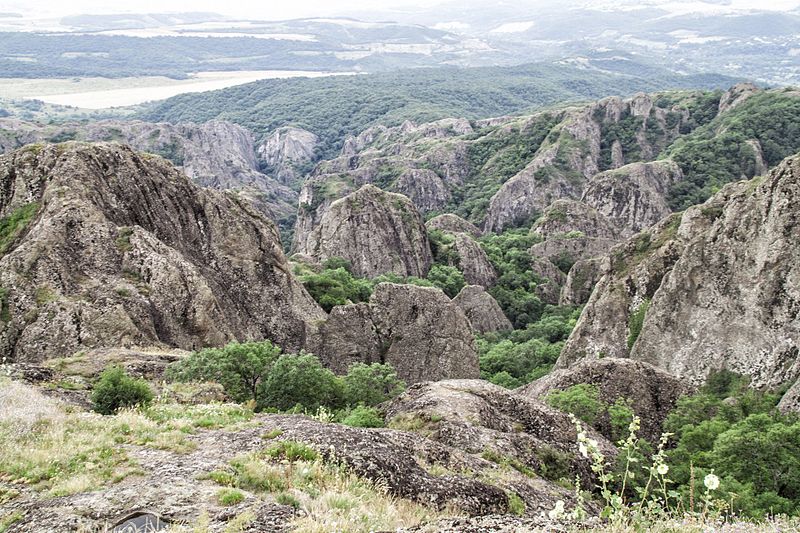
English: Birtvisi Natural Monument is a ruined medieval fortress in Kvemo Kartli, Georgia, nested within limestone cliffs in the Algeti river gorge. It is now within the boundaries of the Tetri-Tsqaro municipality, adjacent to the Algeti National Park, south-west of the nation's capital Tbilisi.
Birtvisi is essentially a natural rocky fortress of 1 km², secured by walls and towers, the most prominent of which – known as Sheupovari ("Obstinate") – tops the tallest rock in the area. Various accessory structures, an aqueduct included, have also survived.[2] In written sources, Birtvisi is first mentioned as a possession of the Arab amir of Tiflis of which he was divested by the Georgian nobles Liparit, Duke of Kldekari and Ivane Abazasdze in 1038.[3] In medieval Georgia, Birtvisi entertained a reputation of an impregnable stronghold whose master could control the entire strategic Algeti gorge. The Turco-Mongol amir Timur notably reduced the fortress during one of his invasions of Georgia in 1403.[4] After the partition of the Kingdom of Georgia later in the 15th century, Birtvisi was within the borders of the Kingdom of Kartli and in possession of the princes Baratashvili.[2] |
| Date | |
| Source | Own work |
| Author | Paata vardanashvili |
| Openstreetmap entry | Link to Openstreetmap |
| Object location | | View this and other nearby images on: OpenStreetMap |
|---|
Licensing
[edit]
I, the copyright holder of this work, hereby publish it under the following license:
This file is licensed under the Creative Commons Attribution-Share Alike 4.0 International license.
- You are free:
- to share – to copy, distribute and transmit the work
- to remix – to adapt the work
- Under the following conditions:
- attribution – You must give appropriate credit, provide a link to the license, and indicate if changes were made. You may do so in any reasonable manner, but not in any way that suggests the licensor endorses you or your use.
- share alike – If you remix, transform, or build upon the material, you must distribute your contributions under the same or compatible license as the original.
This image was uploaded as part of Wiki Loves Earth 2017.
|
 |
File history
Click on a date/time to view the file as it appeared at that time.
| Date/Time | Thumbnail | Dimensions | User | Comment | |
|---|---|---|---|---|---|
| current | 09:41, 5 June 2017 | | 2,000 × 1,333 (1.24 MB) | Paata vardanashvili (talk | contribs) | User created page with UploadWizard |
You cannot overwrite this file.
File usage on Commons
The following 4 pages use this file: