File:Birch Polypore (Piptoporus betulinus) - geograph.org.uk - 1553987.jpg
Birch_Polypore_(Piptoporus_betulinus)_-_geograph.org.uk_-_1553987.jpg (640 × 480 pixels, file size: 92 KB, MIME type: image/jpeg)
Captions
Captions
Summary
[edit]_-_geograph.org.uk_-_1553987.jpg&action=edit§ion=1)
| Description |
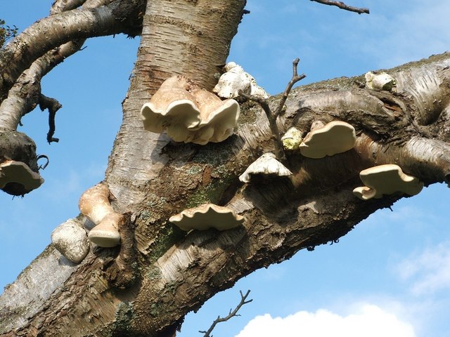
English: Birch Polypore (Piptoporus betulinus). The British Mycological Society recommends both "Birch Polypore" and "Razorstrop Fungus" as colloquial names for this fairly common species, whose fruiting bodies are found from summer to autumn on the dead wood of birch trees.
For a view of the whole tree in context, see 1553991, where it is visible in front of the pine trees. According to "Fungi of Switzerland - Volume 2: Non gilled fungi" (Breitenbach and Kränzlin), the undersurface of the fruiting body is cream-white when young, darkening with age, and the "old fruiting bodies are often attacked by the ascomycete Hypocrea pulvinata"; for a photograph of such an infection, see 1449039. The same work notes that Birch Polypore "causes carbonizing rots"; these are also known as "brown rots". [Two important kinds of fungal rot in wood are referred to as white rots and brown rots. Both attack certain constituents of the wood (cellulose and hemicellulose). White rots also attack lignin, making the wood pale, stringy, and fibrous. Brown rots leave lignin almost untouched, making the wood darker and more brittle, and often causing cubical patterns of cracks (see http://www.biology.ed.ac.uk/research/groups/jdeacon/FungalBiology/woodrots.htm ). Brown rots are of vital importance for forest ecosystems: they leave humus as their residue, and it is largely due to this residue that conifer seedlings often sprout along the line where a fallen conifer lay; see "Introductory Mycology" (Alexopoulos/Mims/Blackwell).] |
| Date | |
| Source | From geograph.org.uk |
| Author | Lairich Rig |
| Attribution (required by the license) | Lairich Rig / Birch Polypore (Piptoporus betulinus) / |
| Camera location | | View this and other nearby images on: OpenStreetMap |
|---|
_-_geograph.org.uk_-_1553987.jpg¶ms=055.962880_N_-004.617900_E_globe:Earth_type:camera_source:geograph-osgb36(NS36687752)_heading:0.00&language=en)
| Object location | | View this and other nearby images on: OpenStreetMap |
|---|
_-_geograph.org.uk_-_1553987.jpg¶ms=055.962880_N_-004.617900_E_globe:Earth_class:object_type:object_source:geograph-osgb36(NS36687752)_heading:0.00&language=en)
Licensing
[edit]_-_geograph.org.uk_-_1553987.jpg&action=edit§ion=2)

|
This image was taken from the Geograph project collection. See this photograph's page on the Geograph website for the photographer's contact details. The copyright on this image is owned by Lairich Rig and is licensed for reuse under the Creative Commons Attribution-ShareAlike 2.0 license.
|
- You are free:
- to share – to copy, distribute and transmit the work
- to remix – to adapt the work
- Under the following conditions:
- attribution – You must give appropriate credit, provide a link to the license, and indicate if changes were made. You may do so in any reasonable manner, but not in any way that suggests the licensor endorses you or your use.
- share alike – If you remix, transform, or build upon the material, you must distribute your contributions under the same or compatible license as the original.
File history
Click on a date/time to view the file as it appeared at that time.
| Date/Time | Thumbnail | Dimensions | User | Comment | |
|---|---|---|---|---|---|
| current | 12:34, 3 March 2011 | | 640 × 480 (92 KB) | GeographBot (talk | contribs) | == {{int:filedesc}} == {{Information |description={{en|1=Birch Polypore (Piptoporus betulinus) The British Mycological Society recommends both "Birch Polypore" and "Razorstrop Fungus" as colloquial names for this fairly common species, whose fruiting bodi |
You cannot overwrite this file.
File usage on Commons
The following page uses this file:
File usage on other wikis
The following other wikis use this file:
- Usage on cs.wikipedia.org
- Usage on de.wikipedia.org
- Usage on en.wikipedia.org
- Usage on sv.wikipedia.org
_-_geograph.org.uk_-_1553987.jpg&oldid=937553928)