File:Binnendüne Waltersberge 02.jpg
Jump to navigation
Jump to search
Size of this preview: 800 × 597 pixels. Other resolutions: 320 × 239 pixels | 640 × 478 pixels | 1,024 × 764 pixels | 1,280 × 955 pixels | 2,560 × 1,911 pixels | 3,339 × 2,492 pixels.
Original file (3,339 × 2,492 pixels, file size: 2.59 MB, MIME type: image/jpeg)
Captions
Captions
Add a one-line explanation of what this file represents
Summary
[edit]
| Description |
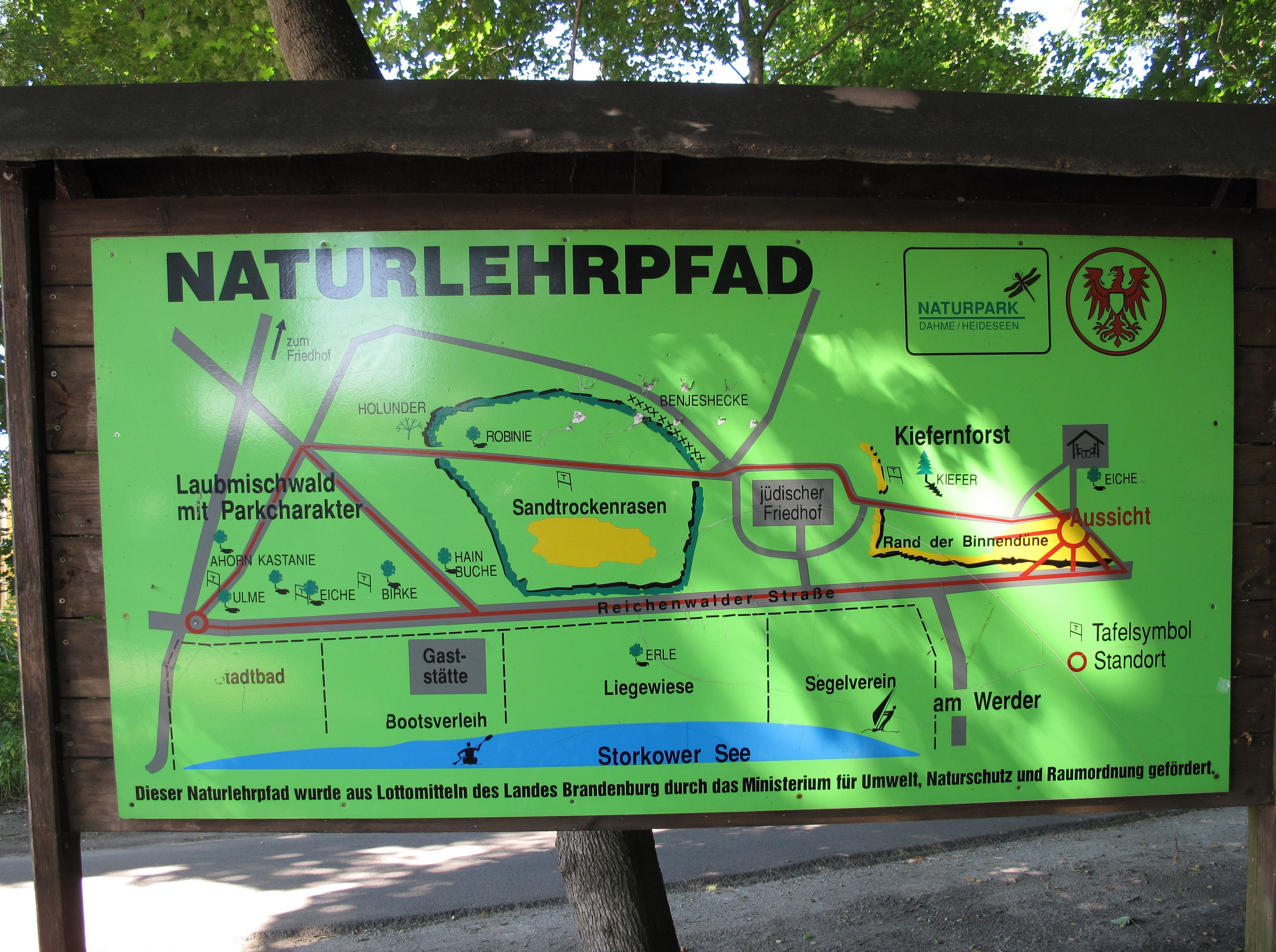
Deutsch: Karte des Naturlehrpfads „Binnendüne Waltersberge in Storkow (Mark)“ von 2011. Die Binnendüne Waltersberge ist eine der größten Binnendünen Brandenburgs. Sie liegt in der Kleinstadt Storkow im Landkreis Oder-Spree am Ostrand des Naturparks Dahme-Heideseen. Der Kern des Dünenkomplexes steht mit rund 14 Hektar als Naturschutzgebiet Binnendüne Waltersberge unter Schutz und ist als FFH-Gebiet im Natura 2000 Verbund ausgewiesen. Fast unmittelbar an das Nordufer des Großen Storkower Sees grenzend, erhebt sich die Düne mit dem 69 Meter hohen Storkower Weinberg um bis zu 32 Meter über die Wasserfläche des Sees.
English: Map of the educational path „Binnendüne Waltersberge in Storkow (Mark)“, placed in 2011. The „Binnendüne Waltersberge“ is one of the largest inland dunes in Brandenburg, Germany. The dune is situated in the town Storkow, District Oder-Spree, just over the eastern border of the Dahme-Heideseen Nature Park. The centre of the area, which covers about 14 hectare, is designated as a Naturschutzgebiet (protected area) and Natura 2000-area. Nearly just beside the northern bank of the Großer Storkower See (lake), rises above the dune with its largest peak, the Storkower Weinberg (69 metres), up to 32 metres over the sea. |
| Date | |
| Source | Own work (The picture is gemeinfrei (~ Public Domain) because of Panoramafreiheit) |
| Author | Lienhard Schulz |
Licensing
[edit]
I, the copyright holder of this work, hereby publish it under the following license:
This file is licensed under the Creative Commons Attribution-Share Alike 3.0 Unported license.
- You are free:
- to share – to copy, distribute and transmit the work
- to remix – to adapt the work
- Under the following conditions:
- attribution – You must give appropriate credit, provide a link to the license, and indicate if changes were made. You may do so in any reasonable manner, but not in any way that suggests the licensor endorses you or your use.
- share alike – If you remix, transform, or build upon the material, you must distribute your contributions under the same or compatible license as the original.
|
The photographical reproduction of this work is covered under the article § 59 of the German copyright law, which states that "It shall be permissible to reproduce, by painting, drawing, photography or cinematography, works which are permanently located on public ways, streets or places and to distribute and publicly communicate such copies. For works of architecture, this provision shall be applicable only to the external appearance."
As with all other “limits of copyright by legally permitted uses”, no changes to the actual work are permitted under § 62 of the German copyright law (UrhG). See Commons:Copyright rules by territory/Germany#Freedom of panorama for more information.
|
File history
Click on a date/time to view the file as it appeared at that time.
| Date/Time | Thumbnail | Dimensions | User | Comment | |
|---|---|---|---|---|---|
| current | 12:05, 20 September 2013 | | 3,339 × 2,492 (2.59 MB) | Lienhard Schulz (talk | contribs) | {{Information |Description= {{de|Karte des Naturlehrpfads „Binnendüne Waltersberge in Storkow (Mark)“ von 2011. Die Binnendüne Waltersberge ist eine der größten Binnendünen ... |
You cannot overwrite this file.
File usage on Commons
There are no pages that use this file.
File usage on other wikis
The following other wikis use this file:
- Usage on de.wikipedia.org