File:Bildsten och port, Härstain i Fröjel.jpg
Jump to navigation
Jump to search

Size of this preview: 401 × 600 pixels. Other resolutions: 160 × 240 pixels | 321 × 480 pixels | 513 × 768 pixels | 685 × 1,024 pixels | 2,466 × 3,688 pixels.
Original file (2,466 × 3,688 pixels, file size: 13.45 MB, MIME type: image/jpeg)
Captions
Captions
Add a one-line explanation of what this file represents
Summary
[edit]
| Description |
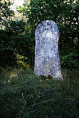
Svenska: Denna bildsten är en av de få som står kvar på sin ursprungliga plats, en minst 1200 år gammal väg i Fröjels socken på Gotland. Bemålningen är borta, men stenens ytterkontur är kvar. Enligt en hypotes kan den representera en port till ett rike bortom det jordiska; ett dödsrike eller Paradiset.
English: This picture stone is one of the few that still stands at its original location, an at least 1200 years old roadway in the parish of Fröjel, Gotland, Sweden. All traces of inscripion or paint is gone, but the contour of the stone is intact. By one hypothesis it can represent a portal to another world; a kingdom of death or the Paradise.
|
||
| Date | |||
| Source | Own work | ||
| Author | Måns Hagberg |
| Camera location | | View this and other nearby images on: OpenStreetMap |
|---|
Licensing
[edit]
I, the copyright holder of this work, hereby publish it under the following license:
This file is licensed under the Creative Commons Attribution-Share Alike 4.0 International license.
- You are free:
- to share – to copy, distribute and transmit the work
- to remix – to adapt the work
- Under the following conditions:
- attribution – You must give appropriate credit, provide a link to the license, and indicate if changes were made. You may do so in any reasonable manner, but not in any way that suggests the licensor endorses you or your use.
- share alike – If you remix, transform, or build upon the material, you must distribute your contributions under the same or compatible license as the original.

|
This image was uploaded as part of Wiki Loves Monuments 2022.
|
File history
Click on a date/time to view the file as it appeared at that time.
| Date/Time | Thumbnail | Dimensions | User | Comment | |
|---|---|---|---|---|---|
| current | 16:13, 20 September 2022 | | 2,466 × 3,688 (13.45 MB) | Magnus 0038 (talk | contribs) | Uploaded own work with UploadWizard |
You cannot overwrite this file.
File usage on Commons
The following page uses this file:
File usage on other wikis
The following other wikis use this file:
- Usage on sv.wikipedia.org