File:Białystok general city plan 2019 01.jpg
From Wikimedia Commons, the free media repository
Jump to navigation
Jump to search

Size of this preview: 680 × 600 pixels. Other resolutions: 272 × 240 pixels | 544 × 480 pixels | 871 × 768 pixels | 1,161 × 1,024 pixels | 2,321 × 2,048 pixels | 13,383 × 11,808 pixels.
Original file (13,383 × 11,808 pixels, file size: 22.98 MB, MIME type: image/jpeg)
File information
Structured data
Captions
Captions
Add a one-line explanation of what this file represents
Summary
[edit]| DescriptionBiałystok general city plan 2019 01.jpg |
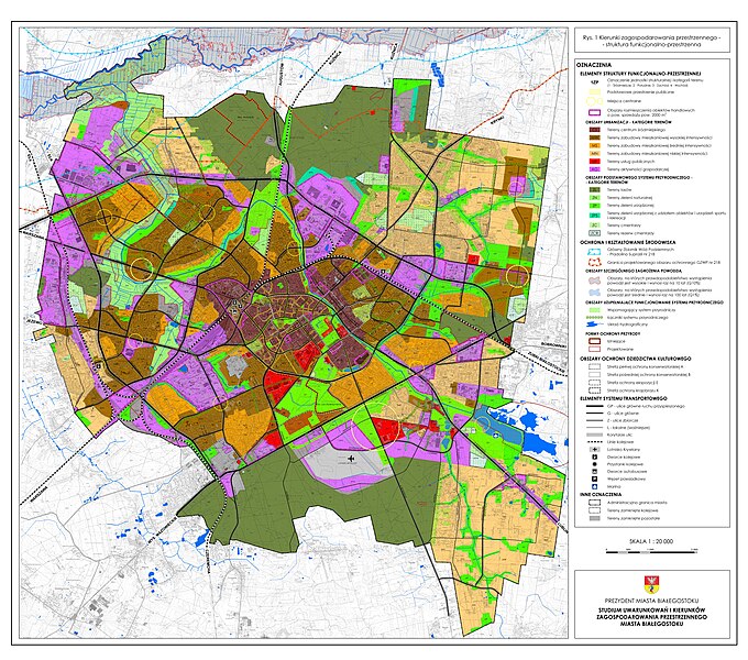
Polski: Studium uwarunkowań i kierunków zagospodarowania przestrzennego miasta Białegostoku, 2019r. Uchwała Nr XII/165/19 Rady Miasta Białystok z dnia 18 czerwca 2019.
English: The design of the study was developed under the supervision of the Mayor of Białystok, Tadeusz Truskolaski, in the Department of Urban Planning of the City Hall in Białystok, by the author's team consisting of: main designers: Piotr Firsowicz, M.A., Architect, Elzbieta Cukrowska, planning team: Krzysztof Czarnomysy, Elżbieta Drożdżal, Marek Fiedoruk, Emilia Klima, Michał Kwiatowski, Olga Lewandowska, Ewa Małyszko, Adam Półtoryczki, Agnieszka Rozosinska, Sebastian Wicher, Elżbieta Zalewska. The main direction of the city's spatial development, taking into account the provisions of the 2010 Development Strategy for the City of Białystok for 2011-2020, was the "inward development of the city", as a compact city that will develop in a ring-radial system within its current borders without expanding them. The basic directions of shaping the spatial composition are: intensification of development in the internal (urban) area, maintaining the extensive character of development in the external area (pre-city), creating a hierarchical system of central places (concentration of service functions and public spaces), creating an urban "green axis" based on the course the Biała River valley, building a metropolitan structure within the city center, building the continuity of the urban fabric, creating new units of spatial composition in areas requiring transformation. The basis of the functional and spatial structure model, which is a continuation of the development of the existing structure, is formed by four structural units (Central, South, West and East) - groups of areas with a significant degree of independence in the field of housing, services, economic activity, green areas and recreation, separated by railway lines and streets of the basic system. Within individual structural units, there are central places with different scales of influence: "downtown center" - the most important in the city's hierarchy, "South Pole", "Western Pole", "Eastern Pole" and smaller local service centers. Based on the route of the city ring road, the city structure is divided into areas: internal - urban with intensive urbanization and external - suburbs - with lower intensity of development, with a large share of green areas and open landscape. In the city's spatial structure, areas of the city's natural system with the highest environmental values have been identified. |
| Date | |
| Source | https://www.bialystok.pl/pl/dla_biznesu/zagospodarowanie_przestrzenne/dokumenty_planistyczne_/studium.html |
| Author | Białystok City Hall |
Licensing
[edit]| Public domainPublic domainfalsefalse |
This image is in the public domain according to Article 4, case 2 of the Polish Copyright Law Act of February 4, 1994 (Dz. U. z 2022 r. poz. 2509 with later changes) "normative acts and drafts thereof as well as official documents, materials, signs and symbols are not subject to copyrights". Hence it is assumed that this image has been released into public domain. However in some instances the use of this image in Poland might be regulated by other laws.
|
 |
File history
Click on a date/time to view the file as it appeared at that time.
| Date/Time | Thumbnail | Dimensions | User | Comment | |
|---|---|---|---|---|---|
| current | 08:27, 7 November 2023 |  | 13,383 × 11,808 (22.98 MB) | Rakoon (talk | contribs) | Uploaded a work by Białystok City Hall from https://www.bialystok.pl/pl/dla_biznesu/zagospodarowanie_przestrzenne/dokumenty_planistyczne_/studium.html with UploadWizard |
You cannot overwrite this file.
File usage on Commons
There are no pages that use this file.