File:Bhakhda Dam View During Sunset with a view of smoke of an aircraft.jpg
Original file (3,648 × 2,736 pixels, file size: 1.78 MB, MIME type: image/jpeg)
Captions
Summary
[edit]DescriptionBhakhda Dam View During Sunset with a view of smoke of an aircraft.jpg |
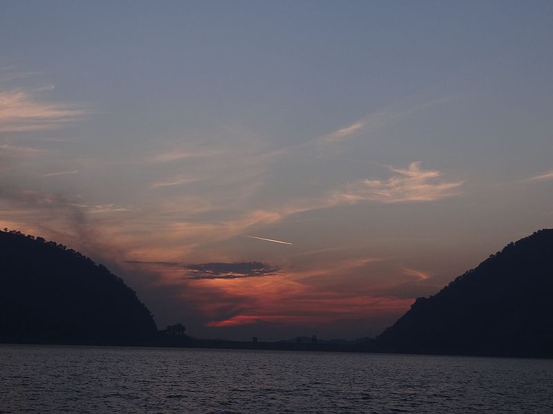
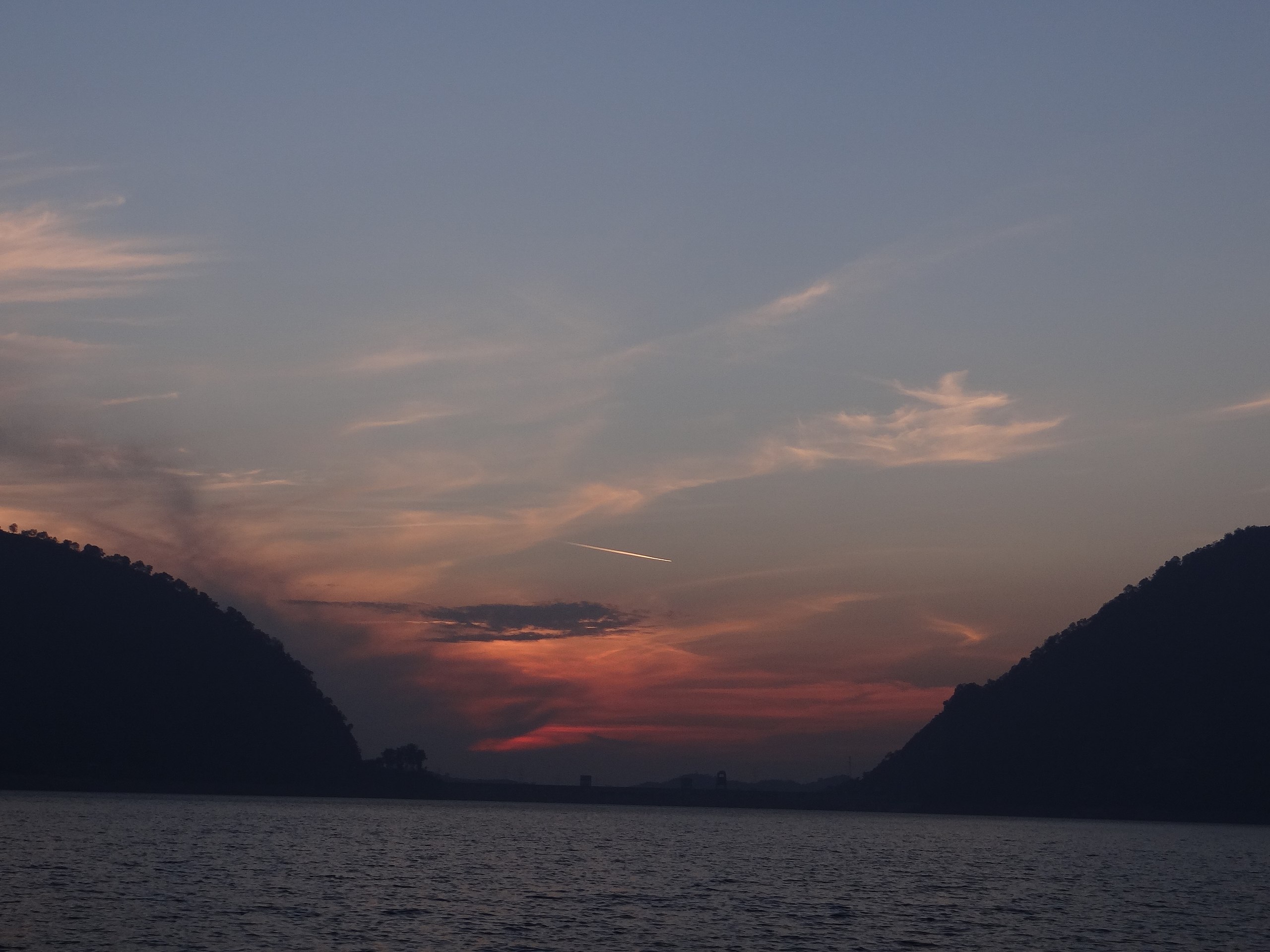
English: Bhakhda Dam View During Sunset with a view of smoke of an aircraft in the sky giving a magical appearance of broken star. |
Date | |
Source | Own work |
Author | Ambuj Mishra |
Camera location | 31° 25′ 09.02″ N, 76° 27′ 18″ E | View this and other nearby images on: OpenStreetMap | 31.419172; 76.455000 |
---|
this image has been taken from a boat during sun set...in the red sky...booster smoke of the air craft is giving a magical appearance of broken star.
Licensing
[edit]- You are free:
- to share – to copy, distribute and transmit the work
- to remix – to adapt the work
- Under the following conditions:
- attribution – You must give appropriate credit, provide a link to the license, and indicate if changes were made. You may do so in any reasonable manner, but not in any way that suggests the licensor endorses you or your use.
- share alike – If you remix, transform, or build upon the material, you must distribute your contributions under the same or compatible license as the original.
This image was uploaded as part of Wiki Loves Earth 2016.
aragonés | العربية | asturianu | azərbaycanca | беларуская (тарашкевіца) | български | বাংলা | brezhoneg | català | čeština | Cymraeg | Deutsch | Ελληνικά | English | español | eesti | euskara | فارسی | français | galego | עברית | hrvatski | հայերեն | Bahasa Indonesia | italiano | 日本語 | ქართული | 한국어 | latviešu | македонски | മലയാളം | मराठी | Bahasa Melayu | norsk bokmål | नेपाली | Nederlands | norsk | polski | português | português do Brasil | русский | sicilianu | shqip | slovenščina | српски / srpski | svenska | ไทย | Türkçe | українська | اردو | 中文 | 中文(台灣) | +/− |
File history
Click on a date/time to view the file as it appeared at that time.
Date/Time | Thumbnail | Dimensions | User | Comment | |
---|---|---|---|---|---|
current | 12:02, 30 June 2016 | 3,648 × 2,736 (1.78 MB) | Ambujmishra0989 (talk | contribs) | User created page with UploadWizard |
You cannot overwrite this file.
File usage on Commons
There are no pages that use this file.
Metadata
This file contains additional information such as Exif metadata which may have been added by the digital camera, scanner, or software program used to create or digitize it. If the file has been modified from its original state, some details such as the timestamp may not fully reflect those of the original file. The timestamp is only as accurate as the clock in the camera, and it may be completely wrong.
Camera manufacturer | SONY |
---|---|
Camera model | DSC-HX100V |
Exposure time | 1/250 sec (0.004) |
F-number | f/4 |
ISO speed rating | 100 |
Date and time of data generation | 17:25, 27 December 2015 |
Lens focal length | 10.05 mm |
Latitude | 31° 25′ 9.02″ N |
Longitude | 76° 27′ 18″ E |
Altitude | 483.72 meters above sea level |
Orientation | Normal |
Horizontal resolution | 72 dpi |
Vertical resolution | 72 dpi |
File change date and time | 17:25, 27 December 2015 |
Y and C positioning | Co-sited |
Exposure Program | Landscape mode (for landscape photos with the background in focus) |
Exif version | 2.3 |
Date and time of digitizing | 17:25, 27 December 2015 |
Meaning of each component |
|
Image compression mode | 1 |
APEX brightness | 7.07578125 |
APEX exposure bias | 0 |
Maximum land aperture | 3 APEX (f/2.83) |
Metering mode | Pattern |
Light source | Unknown |
Flash | Flash did not fire, auto mode |
Supported Flashpix version | 1 |
Color space | sRGB |
File source | Digital still camera |
Scene type | A directly photographed image |
Custom image processing | Normal process |
Exposure mode | Auto exposure |
White balance | Auto white balance |
Digital zoom ratio | 1 |
Scene capture type | Landscape |
Contrast | Normal |
Saturation | Normal |
Sharpness | Normal |
GPS time (atomic clock) | 11:55 |
Receiver status | Measurement in progress |
Measurement mode | 3-dimensional measurement |
Measurement precision | Poor (1.2016) |
Speed unit | Kilometers per hour |
Speed of GPS receiver | 6.371 |
Reference for direction of movement | True direction |
Direction of movement | 246.66 |
Reference for direction of image | Magnetic direction |
Direction of image | 239.75 |
Geodetic survey data used | WGS-84 |
GPS date | 27 December 2015 |
GPS differential correction | 0 |
GPS tag version | 0.0.3.2 |
Structured data
Items portrayed in this file
depicts
27 December 2015
31°25'9.01898"N, 76°27'18.00101"E
image/jpeg
2f854b1b14d03dd0ff80f3d512838c9b4894298f
1,869,402 byte
2,736 pixel
3,648 pixel
- Files with coordinates missing SDC location of creation
- CC-BY-SA-4.0
- Self-published work
- Images from Wiki Loves Earth 2016
- Images from Wiki Loves Earth 2016 in India
- Images from Wiki Loves Earth missing SDC depicts
- Images from Wiki Loves Earth missing SDC location of creation
- Uploaded via Campaign:wle-in
- India photographs taken on 2015-12-27