File:Bevölkerungsentwicklung Bad Liebenwerda.svg
Jump to navigation
Jump to search

Size of this PNG preview of this SVG file: 800 × 560 pixels. Other resolutions: 320 × 224 pixels | 640 × 448 pixels | 1,024 × 717 pixels | 1,280 × 896 pixels | 2,560 × 1,792 pixels | 1,010 × 707 pixels.
Original file (SVG file, nominally 1,010 × 707 pixels, file size: 465 KB)
Captions
Captions
Add a one-line explanation of what this file represents
Summary
[edit]| Description |
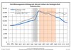
中文:巴特利本韦达,埃尔贝-艾尔斯特区,勃兰登堡州,德国现行边界内的人口发展
蓝线:人口 -- 虚线:与勃兰登堡州人口发展的比较 灰色背景:纳粹统治时期 -- 红色背景:共产主义统治时期 Deutsch: Bevölkerungsentwicklung in den heutigen Grenzen von Bad Liebenwerda, Landkreis Elbe-Elster, Land Brandenburg, Deutschland
Blaue Linie: Bevölkerung -- Punktierte Linie: Vergleich mit der Entwicklung Brandenburgs Grauer Hintergrund: Zeit der Nazi-Herrschaft -- Roter Hintergrund: DDR-Zeit English: Population development within the current boundaries of Bad Liebenwerda, Elbe-Elster district, Brandenburg state, Germany
Blue line: Population -- Dotted line: Comparison to population development of Brandenburg state Grey background: Time of nazi rule -- Red background: Time of communist rule Español: Desarrollo de la población en los actuales límites de Bad Liebenwerda, distrito de Elbe-Elster, estado de Brandenburg, Alemania
Línea azul: Habitantes -- Línea de puntos: Comparación con el desarrollo de Brandenburgo Fondo gris: Período del gobierno nazi -- Fondo Rojo: Época communista हिन्दी: बाद लीबेनवेर्डा, एल्ब-एल्स्टर जिला, ब्रांडेनबर्ग राज्य, जर्मनी की वर्तमान सीमाओं के भीतर जनसंख्या विकास
नीली रेखा: जनसंख्या -- डॉटेड रेखा: ब्रांडेनबर्ग राज्य के जनसंख्या विकास की तुलना धूप रंग: नाजी शासन का समय -- लाल रंग: साम्यवादी शासन का समय العربية: تطور السكان داخل الحدود الحالية لمنطقة باد ليبنفيردا في مقاطعة إلب-إلستر، ولاية براندنبورغ، ألمانيا
الخط الأزرق: السكان -- الخط المنقط: مقارنة بتطور السكان في ولاية براندنبورغ الخلفية الرمادية: فترة حكم النازية -- الخلفية الحمراء: فترة حكم الشيوعي Français : Développement de la population dans les limites actuelles de Bad Liebenwerda, arrondissement de Elbe-Elster, Land de Brandebourg, Allemagne
Ligne bleue: Population -- Ligne pointillé: Comparaison avec le développement de Brandebourg Fond gris: Période du régime nazie -- Fond rouge: Période du régime communiste Русский: Развитие населения в пределах текущих границ района Бад-Либенверда, округ Эльбе-Эльстер, штат Бранденбург, Германия
Синяя линия: Население -- Пунктирная линия: Сравнение с развитием населения штата Бранденбург Серый фон: Время нацистского правления -- Красный фон: Время коммунистического правления Українська: Розвиток населення в межах поточних кордонів Бад-Лібенверда, округ Ельбе-Ельстер, штат Бранденбург, Німеччина
Синя лінія: Населення -- Пунктирна лінія: Порівняння з розвитком населення штату Бранденбург Сірий фон: Час нацистського правління -- Червоний фон: Час комуністичного правління Português: Desenvolvimento populacional dentro dos limites atuais de Bad Liebenwerda, distrito de Elbe-Elster, estado de Brandemburgo, Alemanha
Linha azul: População -- Linha pontilhada: Comparação com o desenvolvimento populacional do estado de Brandemburgo Fundo cinza: Período do regime nazista -- Fundo vermelho: Período do regime comunista বাংলা: ব্যাড লিবেনভেরডা, এলব-এলস্টার জেলা, ব্র্যান্ডেনবুর্গ রাজ্য, জার্মানির বর্তমান সীমান্তে জনসংখ্যা বিকাস
নীল রেখা: জনসংখ্যা -- ডটেড রেখা: ব্র্যান্ডেনবুর্গ রাজ্যের জনসংখ্যা বিকাসের সাথে তুলনা ধূসর পটভূমি: নাজি শাসনের সময় -- লাল পটভূমি: সাম্যবাদী শাসনের সময় Kiswahili: Maendeleo ya idadi ya watu ndani ya mipaka ya sasa ya Bad Liebenwerda, Wilaya ya Elbe-Elster, Jimbo la Brandenburg, Ujerumani
Laini ya bluu: Idadi ya watu -- Laini iliyochorwa: Linganisha na maendeleo ya idadi ya watu ya Jimbo la Brandenburg Rangi ya kijivu: Wakati wa utawala wa Kinazi -- Rangi nyekundu: Wakati wa utawala wa Kikomunisti Italiano: Sviluppo della popolazione entro gli attuali confini de Bad Liebenwerda, circondario de Elbe-Elster, stato federato de Brandeburgo, Germania
Linea Blu: Popolazione -- Linea puntata: Confronto dello sviluppo della popolazione dello stato del Brandenburgo Sfondo grigio: Ai tempi del governo nazista -- Sfondo rosso: Al tempo del governo comunista Nederlands: Ontwikkeling van de bevolking binnen de huidige grenzen van Bad Liebenwerda, landkreis Elbe-Elster, deelstaat Brandenburg, Duitsland
Blauwe lijn: Bevolking -- Stippellijn: Vergelijking van de ontwikkeling van de bevolking van de deelstaat Brandenburg Grijze achtergrond: tijdens de nazi-regering -- Rode achtergrond: tijdens de communistische regering Polski: Rozwój ludności w obecnych granicach dla Bad Liebenwerda, powiat Elbe-Elster, kraj Brandenburgia, Niemcy
Niebieska linia: Populacja -- Linia przerywana: Porównanie z rozwoju Brandenburgii Szare tło: Okres hitlerowców -- Czerwone tło: Okres rządów komunistycznych Svenska: Befolkningsutvecklingen i de nuvarande gränserna för Bad Liebenwerda, landkreis Elbe-Elster, delstaten Brandenburg, Tyskland
Blå linje: Befolkning -- Prickade linjen: Jämförelse med utvecklingen av Brandenburg Grå bakgrund: Period av Nazi styre -- Röd bakgrund: Period av kommunistiskt styre Dansk: Befolkningsudvikling inden for de nuværende grænser af Bad Liebenwerda, Elbe-Elster-distriktet, Brandenburg-stat, Tyskland
Blå linje: Befolkning -- Prikket linje: Sammenligning med befolkningsudviklingen i Brandenburg-stat Grå baggrund: Tidspunkt for nazistisk styre -- Rød baggrund: Tidspunkt for kommunistisk styre Esperanto: Loĝantaro evoluo ene de la nuntempaj limoj de Bad Liebenwerda, distrikto Elbe-Elster, lando Brandenburg, Germanio Blua linio: Loĝantaro -- Poŝita linio: Komparo kun loĝantarevoluo de la ŝtato Brandenburg Griza fono: Tempo de nazi regado -- Ruĝa fono: Tempo de komunista regado |
| Date | between 1 May 2012 and 19 July 2021 |
| Source | Own work based on: Population Projection Brandenburg at Wikimedia Commons |
| Author | Hans G. Oberlack |
| Permission (Reusing this file) |
I, the copyright holder of this work, hereby publish it under the following license: This file is licensed under the Creative Commons Attribution-Share Alike 3.0 Unported license.
|
| Latest population data | 2020 |
| Object location | | View this and other nearby images on: OpenStreetMap |
|---|
File history
Click on a date/time to view the file as it appeared at that time.
| Date/Time | Thumbnail | Dimensions | User | Comment | |
|---|---|---|---|---|---|
| current | 04:18, 19 January 2024 | | 1,010 × 707 (465 KB) | Zhing'za zï Ïnin (talk | contribs) | {{Information |Description= {{zh|巴特利本韦达,埃尔贝-艾尔斯特区,勃兰登堡州,德国现行边界内的人口发展<br>蓝线:人口 -- 虚线:与勃兰登堡州人口发展的比较<br>灰色背景:纳粹统治时期 -- 红色背景:共产主义统治时期}} {{de|1=Bevölkerungsentwicklung in den heutigen Grenzen von Bad Liebenwerda, Landkreis Elbe-Elster, Land Brandenburg, Deutschland<br>Blaue Linie: Bevölkerung -- Punktierte Linie: Vergleich mit der Entwicklung Brandenburgs <br>Grauer Hintergrund: Zeit der Nazi-Herrschaft -- Roter Hintergrund: DDR-Zeit}} {{en|1=Population development within the current boundaries of... |
You cannot overwrite this file.
File usage on Commons
The following page uses this file: