File:Between Porthselau Bay (nr Whitsands Bay) and Porth Brag nr Sant Stinian (St Justinian), W of St David's, Sir Benfro (Pembrokeshire), Wales 22.jpg
Jump to navigation
Jump to search

Size of this preview: 506 × 599 pixels. Other resolutions: 203 × 240 pixels | 405 × 480 pixels | 649 × 768 pixels | 865 × 1,024 pixels | 2,472 × 2,926 pixels.
Original file (2,472 × 2,926 pixels, file size: 1.86 MB, MIME type: image/jpeg)
Captions
Captions
Between Porthselau Bay (nr Whitsands Bay) and Porth Brag nr Sant Stinian (St Justinian), W of St David's, Sir Benfro (Pembrokeshire), Wales
Summary
[edit]_and_Porth_Brag_nr_Sant_Stinian_(St_Justinian),_W_of_St_David%27s,_Sir_Benfro_(Pembrokeshire),_Wales_22.jpg&action=edit§ion=1)
| Description |
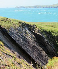
English: Between Porthselau Bay (nr Whitsands Bay) and Porth Brag nr Sant Stinian (St Justinian), W of St David's, Sir Benfro (Pembrokeshire), Wales
Cymraeg: Rhwng Bae Porthselau (ger Traeth Mawr) a Porth Brag ger Sant Stinian i'r Gorll. o Dyddewi, Sir Benfro. |
| Date | |
| Source | Own work |
| Author | Llywelyn2000 |
| Camera location | | View this and other nearby images on: OpenStreetMap |
|---|
_and_Porth_Brag_nr_Sant_Stinian_(St_Justinian),_W_of_St_David%27s,_Sir_Benfro_(Pembrokeshire),_Wales_22.jpg¶ms=051.881645_N_-005.312964_E_globe:Earth_type:camera__&language=en)
Licensing
[edit]_and_Porth_Brag_nr_Sant_Stinian_(St_Justinian),_W_of_St_David%27s,_Sir_Benfro_(Pembrokeshire),_Wales_22.jpg&action=edit§ion=2)
I, the copyright holder of this work, hereby publish it under the following license:
This file is licensed under the Creative Commons Attribution-Share Alike 4.0 International license.
- You are free:
- to share – to copy, distribute and transmit the work
- to remix – to adapt the work
- Under the following conditions:
- attribution – You must give appropriate credit, provide a link to the license, and indicate if changes were made. You may do so in any reasonable manner, but not in any way that suggests the licensor endorses you or your use.
- share alike – If you remix, transform, or build upon the material, you must distribute your contributions under the same or compatible license as the original.
This image was uploaded as part of Wiki Loves Earth 2021.
|
 |
File history
Click on a date/time to view the file as it appeared at that time.
| Date/Time | Thumbnail | Dimensions | User | Comment | |
|---|---|---|---|---|---|
| current | 09:42, 20 June 2021 | | 2,472 × 2,926 (1.86 MB) | Llywelyn2000 (talk | contribs) | Uploaded own work with UploadWizard |
You cannot overwrite this file.
File usage on Commons
There are no pages that use this file.
File usage on other wikis
The following other wikis use this file:
- Usage on cy.wikipedia.org
_and_Porth_Brag_nr_Sant_Stinian_(St_Justinian),_W_of_St_David%27s,_Sir_Benfro_(Pembrokeshire),_Wales_22.jpg&oldid=822636615)