File:Berridale Braes - geograph.org.uk - 162297.jpg
Jump to navigation
Jump to search
Size of this preview: 397 × 599 pixels. Other resolutions: 159 × 240 pixels | 424 × 640 pixels.
Original file (424 × 640 pixels, file size: 234 KB, MIME type: image/jpeg)
Captions
Captions
Add a one-line explanation of what this file represents
Summary
[edit]
| Description |
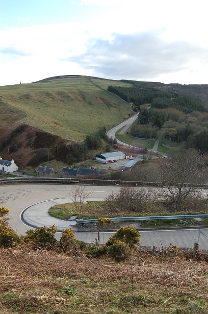
English: Berridale Braes. The A9 is one of only two roads into Caithness and the other way is much longer and single track for much of its length. The railway is an alternative but not much used. At Berridale the A9 is forced to drop around 150 mts from the moor and climb back up again inside a distance of 2 km. This photo shows the hairpin bend on the north side of the Berridale Braes and looks out to the southern side of the dale.
Whilst it is now much modified from the original layout especially down on the dale floor it is still a major obstacle for all heavily laden vehicles particularly coaches and heavy goods vehicles with a long steep drops to the dale floor to keep everybody alert. Note the emergency gravel traps on the southern side. There are none on this side. Taken from the old cemetery. |
| Date | |
| Source | From geograph.org.uk |
| Author | Jim Bain |
| Attribution (required by the license) | Jim Bain / Berridale Braes / |
| Camera location | | View this and other nearby images on: OpenStreetMap |
|---|
_heading:247.00&language=en)
| Object location | | View this and other nearby images on: OpenStreetMap |
|---|
_heading:247.00&language=en)
Licensing
[edit]

|
This image was taken from the Geograph project collection. See this photograph's page on the Geograph website for the photographer's contact details. The copyright on this image is owned by Jim Bain and is licensed for reuse under the Creative Commons Attribution-ShareAlike 2.0 license.
|
This file is licensed under the Creative Commons Attribution-Share Alike 2.0 Generic license.
Attribution: Jim Bain
- You are free:
- to share – to copy, distribute and transmit the work
- to remix – to adapt the work
- Under the following conditions:
- attribution – You must give appropriate credit, provide a link to the license, and indicate if changes were made. You may do so in any reasonable manner, but not in any way that suggests the licensor endorses you or your use.
- share alike – If you remix, transform, or build upon the material, you must distribute your contributions under the same or compatible license as the original.
File history
Click on a date/time to view the file as it appeared at that time.
| Date/Time | Thumbnail | Dimensions | User | Comment | |
|---|---|---|---|---|---|
| current | 12:08, 24 December 2011 | | 424 × 640 (234 KB) | Rotatebot (talk | contribs) | Bot: Image rotated by 90° (EXIF-Orientation set from 8 to 1 - EXIF had minor errors. Some EXIF could be lost. - , rotated 0°) |
| 07:30, 31 January 2010 |  | 640 × 424 (234 KB) | GeographBot (talk | contribs) | == {{int:filedesc}} == {{Information |description={{en|1=Berridale Braes. The A9 is one of only two roads into Caithness and the other way is much longer and single track for much of its length. The railway is an alternative but not much used. At Berridal |
You cannot overwrite this file.
File usage on Commons
There are no pages that use this file.