File:Berninabahn.png
Jump to navigation
Jump to search
Size of this preview: 652 × 599 pixels. Other resolutions: 261 × 240 pixels | 522 × 480 pixels | 836 × 768 pixels | 1,114 × 1,024 pixels | 2,228 × 2,048 pixels | 6,668 × 6,129 pixels.
Original file (6,668 × 6,129 pixels, file size: 3.49 MB, MIME type: image/png)
Captions
Captions
Add a one-line explanation of what this file represents
Summary
[edit]
| Description |
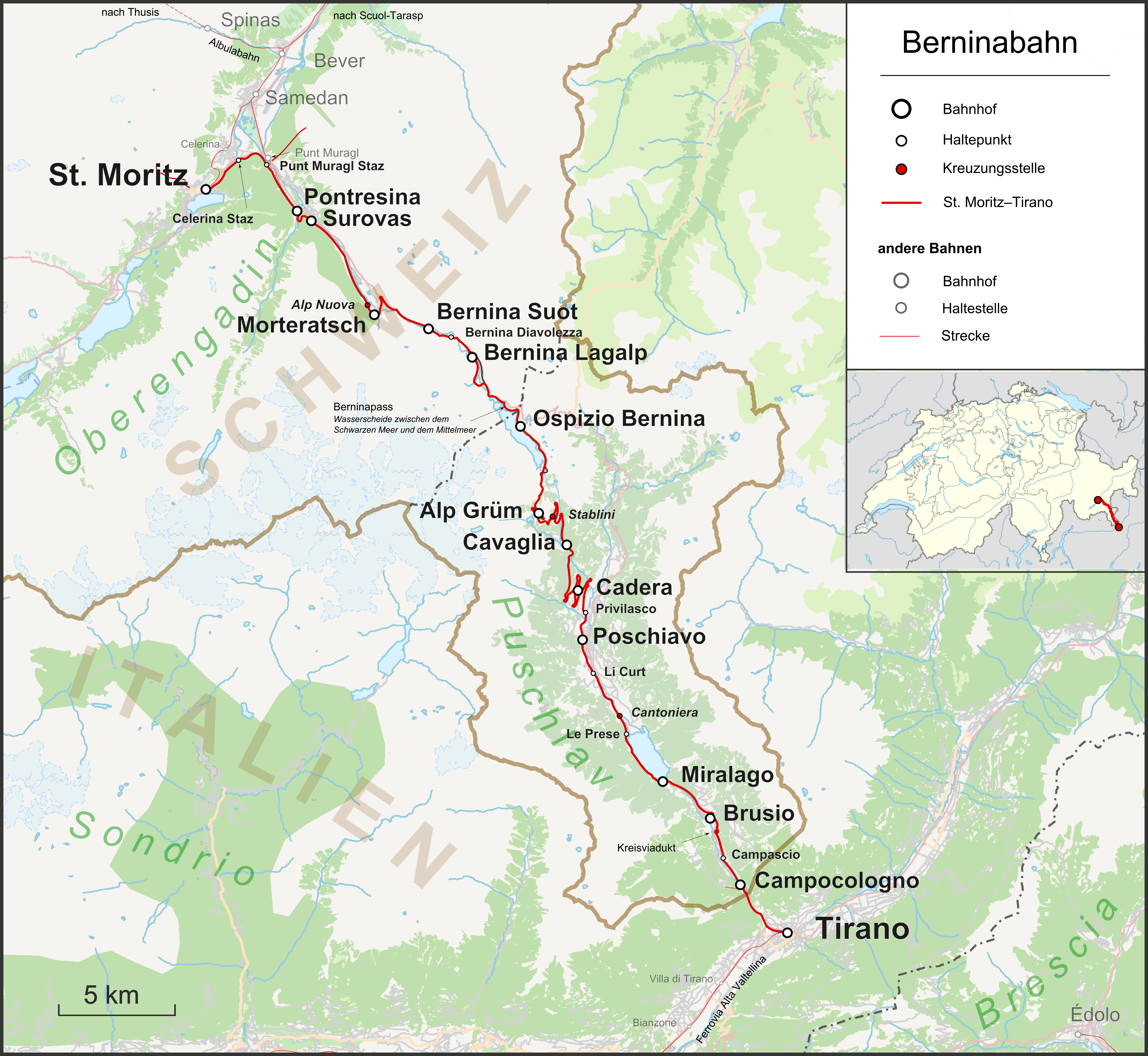
Deutsch: Karte der Berninabahn in der Schweiz |
| Date | |
| Source |
Own work Map was created using:
|
| Author | |
| Permission (Reusing this file) |
Map data (c) OpenStreetMap (and) contributors, CC-BY-SA |
Licensing
[edit]
This file is licensed under the Creative Commons Attribution-Share Alike 2.0 Generic license.
- You are free:
- to share – to copy, distribute and transmit the work
- to remix – to adapt the work
- Under the following conditions:
- attribution – You must give appropriate credit, provide a link to the license, and indicate if changes were made. You may do so in any reasonable manner, but not in any way that suggests the licensor endorses you or your use.
- share alike – If you remix, transform, or build upon the material, you must distribute your contributions under the same or compatible license as the original.
File history
Click on a date/time to view the file as it appeared at that time.
| Date/Time | Thumbnail | Dimensions | User | Comment | |
|---|---|---|---|---|---|
| current | 19:40, 20 May 2017 | | 6,668 × 6,129 (3.49 MB) | Pechristener (talk | contribs) | Acqua da Pila hinzu |
| 01:14, 31 July 2014 |  | 3,334 × 3,064 (1.95 MB) | Pechristener (talk | contribs) | Beschriftung der Täler etwas dunkler | |
| 01:08, 31 July 2014 |  | 3,334 × 3,064 (1.95 MB) | Pechristener (talk | contribs) | Landesgrenze besser, roter Strich weg | |
| 22:45, 27 July 2014 |  | 3,334 × 3,064 (1.72 MB) | Pechristener (talk | contribs) | Kleine Verbesserungen bei der Legende und der Location Map | |
| 22:40, 27 July 2014 |  | 3,334 × 3,064 (1.72 MB) | Pechristener (talk | contribs) | == {{int:filedesc}} == {{Information |Description = {{de|1=Karte der Berninabahn in der Schweiz}} |Source ={{own}} Map was created using: *[http://www.openstreetmap.org/ Open Street Map] *[[:File:Switzerland location... |
You cannot overwrite this file.
File usage on Commons
The following 6 pages use this file:
- User:Chumwa/OgreBot/Potential transport maps/2017 May 11-20
- User:Chumwa/OgreBot/Public transport information/2017 May 11-20
- User:Chumwa/OgreBot/Transport Maps/2017 May 11-20
- User:Chumwa/OgreBot/Travel and communication maps/2017 May 11-20
- Category:Bernina railway
- Category:Views from the Bernina railway
File usage on other wikis
The following other wikis use this file:
- Usage on de.wikipedia.org
- Usage on el.wikipedia.org
- Usage on es.wikipedia.org
- Usage on fr.wikipedia.org
- Usage on fr.wikivoyage.org
- Usage on hu.wikipedia.org
- Usage on it.wikipedia.org
- Usage on it.wikivoyage.org
- Usage on lv.wikipedia.org
- Usage on no.wikipedia.org
- Usage on rm.wikipedia.org
- Usage on ru.wikipedia.org
- Usage on sv.wikipedia.org
- Usage on uk.wikipedia.org
- Usage on www.wikidata.org