File:Bernard. LOC 74692128.jpg
Jump to navigation
Jump to search

Size of this preview: 381 × 600 pixels. Other resolutions: 152 × 240 pixels | 305 × 480 pixels | 488 × 768 pixels | 650 × 1,024 pixels | 2,434 × 3,832 pixels.
Original file (2,434 × 3,832 pixels, file size: 1.12 MB, MIME type: image/jpeg)
Captions
Captions
Add a one-line explanation of what this file represents
Summary
[edit]| Description |
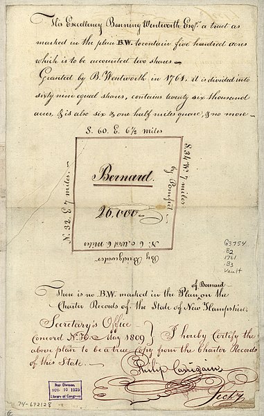
English: Scale ca. 1:127,000. Manuscript, pen-and-ink. Has watermark. Inscription above the plan: His Excellency Benning Wentworth, Esqr., a tract as marked in the plan B.W. to contain five hundred acres which is to be accounted two shares. Granted by B. Wentworth in 1761 ... Note below plan: There is no B.W. marked in the plan of Bernard on the charter records of the state of New Hampshire. Certification below plan: Secretary's office, Concord, N.H., May 1809: I hereby certify the above plan to be a true copy from the charter records of this state. Philip Carrigain, sectry. LC Maps of North America, 1750-1789, 877 Available also through the Library of Congress Web site as a raster image. Vault AACR2 |
||
| Title | Bernard. | ||
| Shelf ID | G3754.B2 1761 .B3 | ||
| Date | |||
| Source | https://www.loc.gov/item/74692128/ | ||
| Author | Unknown author | ||
| Permission (Reusing this file) |
|
||
| Other versions |
|
||
| Location | United States · Barnard (Town) · Vermont · Barnard · Town | ||
| Part of | Military Battles And Campaigns · American Memory · Catalog · Geography And Map Division · American Revolution And Its Era: Maps And Charts Of North America And The West Indies, 1750-1789 | ||
| Subject | Barnard (Vt. : Town) · Vermont · Maps, Manuscript · United States · Barnard (Town) · Early Works To 1800 |


Licensing
[edit]
|
This is a faithful photographic reproduction of a two-dimensional, public domain work of art. The work of art itself is in the public domain for the following reason:
The official position taken by the Wikimedia Foundation is that "faithful reproductions of two-dimensional public domain works of art are public domain".
This photographic reproduction is therefore also considered to be in the public domain in the United States. In other jurisdictions, re-use of this content may be restricted; see Reuse of PD-Art photographs for details. | ||||
File history
Click on a date/time to view the file as it appeared at that time.
| Date/Time | Thumbnail | Dimensions | User | Comment | |
|---|---|---|---|---|---|
| current | 10:59, 1 June 2018 | | 2,434 × 3,832 (1.12 MB) | Fæ (talk | contribs) | LOC Maps https://www.loc.gov/item/74692128/ #16957 |
You cannot overwrite this file.
File usage on Commons
The following page uses this file: