File:Berlin Bernauer Straße Mauerstreifen.jpg
Jump to navigation
Jump to search

Size of this preview: 800 × 585 pixels. Other resolutions: 320 × 234 pixels | 640 × 468 pixels | 1,024 × 749 pixels | 1,280 × 937 pixels | 1,551 × 1,135 pixels.
Original file (1,551 × 1,135 pixels, file size: 508 KB, MIME type: image/jpeg)
Captions
Captions
Add a one-line explanation of what this file represents
Summary
[edit]
| Description |
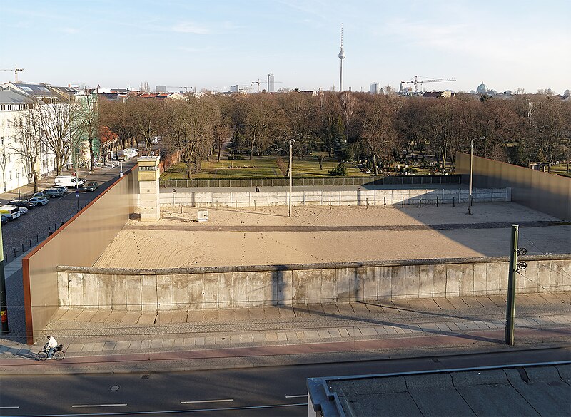
Deutsch: Ein Mauerstreifen an der Bernauer Straße in Berlin-Mitte an der Grenze zu Berlin-Gesundbrunnen, im Ausbauzustand der 1980er Jahre. Die Straße im Vordergrund gehörte zum West-Berliner Bezirk Wedding. Die abgerissenen vierstöckigen Häuser standen direkt an der Bernauer Straße anstelle der Sperranlagen. Aufgenommen vom Turm des Dokumentationszentrum Berliner Mauer auf der Nordseite der Bernauer Straße.
English: The street Bernauer Straße is situated between the localities of Berlin-Gesundbrunnen (West) and Berlin-Mitte (East), today both belonging to the Mitte borough. It runs from the Mauerpark at the corner of Prenzlauer Berg to the Nordbahnhof. Viewed from the tower of the Berlin Wall Documentation Center on Bernauer Straße.
(O3059029-Dv4) |
| Date | |
| Source | Own work |
| Author | Pedelecs |
Licensing
[edit]
Pedelecs by Wikivoyage and Wikipedia, the copyright holder of this work, hereby publishes it under the following license:
This file is licensed under the Creative Commons Attribution-Share Alike 3.0 Unported license.
Attribution: Pedelecs by Wikivoyage and Wikipedia
- You are free:
- to share – to copy, distribute and transmit the work
- to remix – to adapt the work
- Under the following conditions:
- attribution – You must give appropriate credit, provide a link to the license, and indicate if changes were made. You may do so in any reasonable manner, but not in any way that suggests the licensor endorses you or your use.
- share alike – If you remix, transform, or build upon the material, you must distribute your contributions under the same or compatible license as the original.
File history
Click on a date/time to view the file as it appeared at that time.
| Date/Time | Thumbnail | Dimensions | User | Comment | |
|---|---|---|---|---|---|
| current | 21:28, 18 October 2014 | | 1,551 × 1,135 (508 KB) | Pedelecs (talk | contribs) | {{Information |Description ={{de|1=Ein Mauerstreifen an der Bernauer Straße in Berlin-Mitte an der Grenze zu Berlin-Gesundbrunnen, im Ausbauzustand der 1980er Jahre. Die Straße im Vordergrund gehörte zum West-Berliner Bezirk Wedding. Die abgeriss... |
You cannot overwrite this file.
File usage on Commons
There are no pages that use this file.
File usage on other wikis
The following other wikis use this file:
- Usage on de.wikivoyage.org
- Usage on en.wikivoyage.org
- Usage on incubator.wikimedia.org