File:Berkhamsted, The BFI National Archive Kingshill site - geograph.org.uk - 1413077.jpg
Jump to navigation
Jump to search
No higher resolution available.
Berkhamsted,_The_BFI_National_Archive_Kingshill_site_-_geograph.org.uk_-_1413077.jpg (640 × 480 pixels, file size: 71 KB, MIME type: image/jpeg)
Captions
Captions
Add a one-line explanation of what this file represents
Summary
[edit]
| Description |
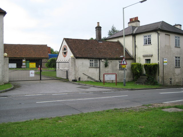
English: Berkhamsted: The BFI National Archive Kingshill site It seems only right and proper that a project whose aim it is to record photographic images of the British Isles should archive the British Film Institute (BFI)'s own National Archive. So for the record this is the rather unprepossessing entry to their Kingshill site in Berkhamsted. In fact the old tiled barn beyond the gates obscures the view to several large modern archive buildings behind and the site is actually known as the J Paul Getty Junior Conservation Centre.
The archive was originally set up as the National Film Library in 1935 and its first curator was Ernest Lindgren. In 1955 its name became the National Film Archive, and, in 1992, the National Film and Television Archive. It was renamed the BFI National Archive in 2006, although the sign outside the site here, inside the red railing, has not yet caught up with the change. The 1883 edition of the Ordnance Survey 6" to the mile map shows an isolated farmstead named Kingshill on the site with the same layout of buildings as visible here. |
| Date | |
| Source | From geograph.org.uk |
| Author | Nigel Cox |
| Attribution (required by the license) | Nigel Cox / Berkhamsted: The BFI National Archive Kingshill site / |
| Camera location | | View this and other nearby images on: OpenStreetMap |
|---|
_heading:202.00&language=en)
| Object location | | View this and other nearby images on: OpenStreetMap |
|---|
_heading:202.00&language=en)
Licensing
[edit]

|
This image was taken from the Geograph project collection. See this photograph's page on the Geograph website for the photographer's contact details. The copyright on this image is owned by Nigel Cox and is licensed for reuse under the Creative Commons Attribution-ShareAlike 2.0 license.
|
This file is licensed under the Creative Commons Attribution-Share Alike 2.0 Generic license.
Attribution: Nigel Cox
- You are free:
- to share – to copy, distribute and transmit the work
- to remix – to adapt the work
- Under the following conditions:
- attribution – You must give appropriate credit, provide a link to the license, and indicate if changes were made. You may do so in any reasonable manner, but not in any way that suggests the licensor endorses you or your use.
- share alike – If you remix, transform, or build upon the material, you must distribute your contributions under the same or compatible license as the original.
File history
Click on a date/time to view the file as it appeared at that time.
| Date/Time | Thumbnail | Dimensions | User | Comment | |
|---|---|---|---|---|---|
| current | 15:11, 1 March 2011 | | 640 × 480 (71 KB) | GeographBot (talk | contribs) | == {{int:filedesc}} == {{Information |description={{en|1=Berkhamsted: The BFI National Archive Kingshill site It seems only right and proper that a project whose aim it is to record photographic images of the British Isles should archive the British Film |
You cannot overwrite this file.
File usage on Commons
The following page uses this file:
File usage on other wikis
The following other wikis use this file:
- Usage on ar.wikipedia.org
- Usage on en.wikipedia.org