File:Bench Mark, Belfast - geograph.org.uk - 1804479.jpg
Bench_Mark,_Belfast_-_geograph.org.uk_-_1804479.jpg (640 × 527 pixels, file size: 505 KB, MIME type: image/jpeg)
Captions
Captions
Summary
[edit]
| Description |
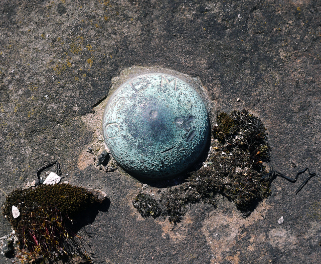
English: Bench Mark, Belfast. A brass bolt bench mark, it is located approximately 1 metre to the south-east of the lock gates to Clarendon Dry Dock No.2 1378194. It is marked "OS BM".
The mark is 2.51 metres above MSL. See also https://www.geograph.org.uk/search.php?i=11037856 for many other examples I have found. This mark is important in the history of geodetic levelling by the Ordnance Survey Northern Ireland. Prior to a new geodetic levelling of Northern Ireland in 1957, all levels in Ireland, north and south, related to Poolbeg Datum. The completion of the 1950s levelling necessitated a new vertical datum for N.Ireland. Thus, the establishment of a new Mean Sea Level (MSL) for Belfast was created through a lenghthy series of tidal observations made at Belfast by the Harbour Board between 1951-56 and this data was shared with OSNI. A tidal gauge at Clarendon Dock was used for the observations; the relationship between the levels on the gauge and a Fundamental Bench Mark at the Grove Playing Fields in Belfast was established via this bolt on the dockside. Thus all levelling data produced on large scale maps by OSNI since the 1960s give height above MSL Belfast (smaller scale maps, such as the 1:50,000 series, refer to MSL Malin in order to ensure compatability throughout Ireland). The information above is taken from sources produced by OSNI available online at http://www.osni.gov.uk/3.3_msl_belfast.doc and http://www.osni.gov.uk/3.2_vertical_datums_in_ireland.doc . |
| Date | |
| Source | From geograph.org.uk |
| Author | Ross |
| Camera location | | View this and other nearby images on: OpenStreetMap |
|---|
_heading:225.00&language=en)
| Object location | | View this and other nearby images on: OpenStreetMap |
|---|
_heading:225.00&language=en)
Licensing
[edit]

|
This image was taken from the Geograph project collection. See this photograph's page on the Geograph website for the photographer's contact details. The copyright on this image is owned by Ross and is licensed for reuse under the Creative Commons Attribution-ShareAlike 2.0 license.
|
- You are free:
- to share – to copy, distribute and transmit the work
- to remix – to adapt the work
- Under the following conditions:
- attribution – You must give appropriate credit, provide a link to the license, and indicate if changes were made. You may do so in any reasonable manner, but not in any way that suggests the licensor endorses you or your use.
- share alike – If you remix, transform, or build upon the material, you must distribute your contributions under the same or compatible license as the original.
File history
Click on a date/time to view the file as it appeared at that time.
| Date/Time | Thumbnail | Dimensions | User | Comment | |
|---|---|---|---|---|---|
| current | 12:25, 14 March 2011 | | 640 × 527 (505 KB) | GeographBot (talk | contribs) | == {{int:filedesc}} == {{Information |description={{en|1=Bench Mark, Belfast A brass bolt bench mark, it is located approximately 1 metre to the south-east of the lock gates to Clarendon Dry Dock No.2 1378194. It is marked "OS BM". The mark is 2.51 m |
You cannot overwrite this file.
File usage on Commons
There are no pages that use this file.