File:Ben Vorlich seen from Ben Vorlich - geograph.org.uk - 1040370.jpg
From Wikimedia Commons, the free media repository
Jump to navigation
Jump to search
![File:Ben Vorlich seen from Ben Vorlich - geograph.org.uk - 1040370.jpg](https://upload.wikimedia.org/wikipedia/commons/thumb/5/5f/Ben_Vorlich_seen_from_Ben_Vorlich_-_geograph.org.uk_-_1040370.jpg/607px-Ben_Vorlich_seen_from_Ben_Vorlich_-_geograph.org.uk_-_1040370.jpg?20110223204216)
Size of this preview: 607 × 599 pixels. Other resolutions: 243 × 240 pixels | 486 × 480 pixels | 640 × 632 pixels.
Original file (640 × 632 pixels, file size: 65 KB, MIME type: image/jpeg)
File information
Structured data
Captions
Captions
Add a one-line explanation of what this file represents
Summary
[edit]DescriptionBen Vorlich seen from Ben Vorlich - geograph.org.uk - 1040370.jpg |
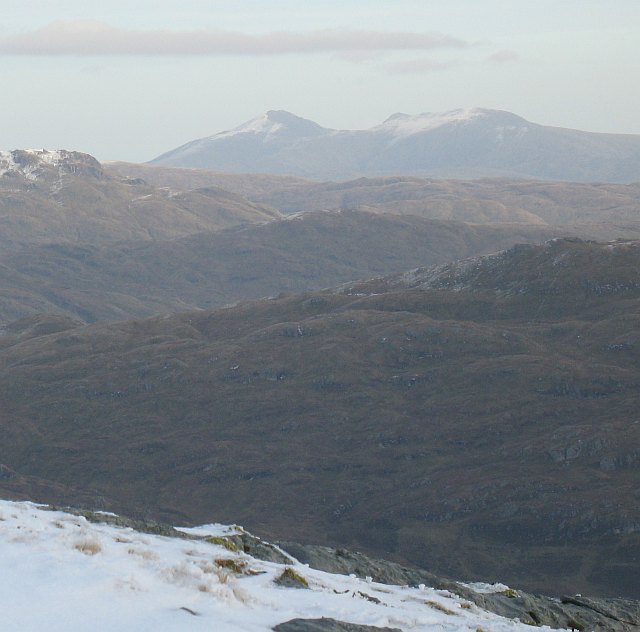
English: Ben Vorlich seen from Ben Vorlich View eastward from near the summit of the Dunbartonshire Ben Vorlich to the Perthshire Ben Vorlich (the pointed summit) The Ben Vorlich above Loch Earn is probably the better known of the two Ben Vorlichs, and is instantly recognisable from many angles by its proximity to Stuc a' Chroin, right.
The Vorlichs are sometimes distinguished by the lochs at their feet. Loch Lomond and Loch Earn. |
Date | |
Source | From geograph.org.uk |
Author | Richard Webb |
Attribution (required by the license) InfoField | Richard Webb / Ben Vorlich seen from Ben Vorlich / |
InfoField | Richard Webb / Ben Vorlich seen from Ben Vorlich |
Camera location | 56° 16′ 19″ N, 4° 45′ 14″ W ![]() ![]() | View this and other nearby images on: OpenStreetMap | ![]() |
---|
Licensing
[edit]![]() |
This image was taken from the Geograph project collection. See this photograph's page on the Geograph website for the photographer's contact details. The copyright on this image is owned by Richard Webb and is licensed for reuse under the Creative Commons Attribution-ShareAlike 2.0 license.
|
![w:en:Creative Commons](https://upload.wikimedia.org/wikipedia/commons/thumb/7/79/CC_some_rights_reserved.svg/90px-CC_some_rights_reserved.svg.png)
![attribution](https://upload.wikimedia.org/wikipedia/commons/thumb/1/11/Cc-by_new_white.svg/24px-Cc-by_new_white.svg.png)
![share alike](https://upload.wikimedia.org/wikipedia/commons/thumb/d/df/Cc-sa_white.svg/24px-Cc-sa_white.svg.png)
This file is licensed under the Creative Commons Attribution-Share Alike 2.0 Generic license.
Attribution: Richard Webb
- You are free:
- to share – to copy, distribute and transmit the work
- to remix – to adapt the work
- Under the following conditions:
- attribution – You must give appropriate credit, provide a link to the license, and indicate if changes were made. You may do so in any reasonable manner, but not in any way that suggests the licensor endorses you or your use.
- share alike – If you remix, transform, or build upon the material, you must distribute your contributions under the same or compatible license as the original.
File history
Click on a date/time to view the file as it appeared at that time.
Date/Time | Thumbnail | Dimensions | User | Comment | |
---|---|---|---|---|---|
current | 20:42, 23 February 2011 | ![]() | 640 × 632 (65 KB) | GeographBot (talk | contribs) | == {{int:filedesc}} == {{Information |description={{en|1=Ben Vorlich seen from Ben Vorlich View eastward from near the summit of the Dunbartonshire Ben Vorlich to the Perthshire Ben Vorlich (the pointed summit) The Ben Vorlich above Loch Earn is probably |
You cannot overwrite this file.
File usage on Commons
There are no pages that use this file.
Metadata
This file contains additional information such as Exif metadata which may have been added by the digital camera, scanner, or software program used to create or digitize it. If the file has been modified from its original state, some details such as the timestamp may not fully reflect those of the original file. The timestamp is only as accurate as the clock in the camera, and it may be completely wrong.
Camera manufacturer | Canon |
---|---|
Camera model | Canon PowerShot A640 |
Exposure time | 1/250 sec (0.004) |
F-number | f/5 |
Date and time of data generation | 14:00, 1 November 2008 |
Lens focal length | 29.2 mm |
Orientation | Normal |
Horizontal resolution | 72 dpi |
Vertical resolution | 72 dpi |
File change date and time | 14:00, 1 November 2008 |
Y and C positioning | Centered |
Exif version | 2.2 |
Date and time of digitizing | 14:00, 1 November 2008 |
Image compression mode | 5 |
APEX shutter speed | 7.96875 |
APEX aperture | 4.65625 |
APEX exposure bias | 0.66666666666667 |
Maximum land aperture | 4.0625 APEX (f/4.09) |
Metering mode | Pattern |
Flash | Flash did not fire, compulsory flash suppression |
Color space | sRGB |
Focal plane X resolution | 12,710.801393728 |
Focal plane Y resolution | 9,525.5813953488 |
Focal plane resolution unit | inches |
Sensing method | One-chip color area sensor |
Custom image processing | Normal process |
Exposure mode | Manual exposure |
White balance | Auto white balance |
Digital zoom ratio | 1 |
Scene capture type | Standard |
Structured data
Items portrayed in this file
depicts
some value
56°16'19"N, 4°45'14"W
1 November 2008
image/jpeg
2e5f6d668e5871ed36241e735284c3a9904ad2f8
66,534 byte
632 pixel
640 pixel
Hidden categories:
- Information field template with formatting
- Files with coordinates missing SDC location of creation
- CC-BY-SA-2.0
- Images from Geograph Britain and Ireland
- Images from Geograph Britain and Ireland missing SDC coordinates of depicted place
- Images by Richard Webb
- United Kingdom photographs taken on 2008-11-01
- Pages with maps