File:Belfast DEAs labelled.png
Jump to navigation
Jump to search
No higher resolution available.
Belfast_DEAs_labelled.png (500 × 480 pixels, file size: 56 KB, MIME type: image/png)
Captions
Captions
Add a one-line explanation of what this file represents
Summary
[edit]
| Description |
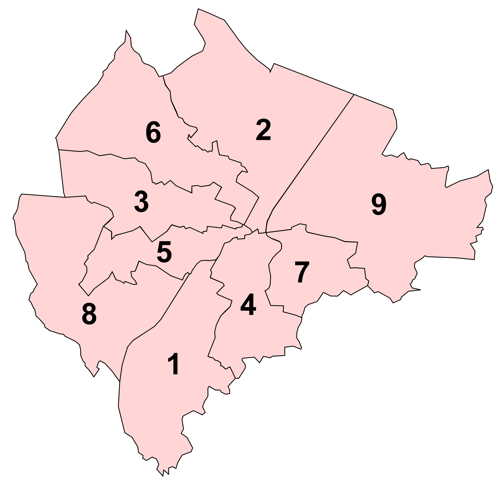
English: Map of the nine District Electoral Areas of Belfast, Northern Ireland numbered in alphabetical order:
1: Balmoral; |
| Date | |
| Source | Own work |
| Author | Rathgarrr |
Licensing
[edit]
I, the copyright holder of this work, hereby publish it under the following license:
This file is licensed under the Creative Commons Attribution-Share Alike 3.0 Unported license.
- You are free:
- to share – to copy, distribute and transmit the work
- to remix – to adapt the work
- Under the following conditions:
- attribution – You must give appropriate credit, provide a link to the license, and indicate if changes were made. You may do so in any reasonable manner, but not in any way that suggests the licensor endorses you or your use.
- share alike – If you remix, transform, or build upon the material, you must distribute your contributions under the same or compatible license as the original.
File history
Click on a date/time to view the file as it appeared at that time.
| Date/Time | Thumbnail | Dimensions | User | Comment | |
|---|---|---|---|---|---|
| current | 00:07, 12 June 2011 | | 500 × 480 (56 KB) | Rathgarrr (talk | contribs) | Smaller version |
| 00:02, 12 June 2011 |  | 5,033 × 4,840 (664 KB) | Rathgarrr (talk | contribs) |
You cannot overwrite this file.
File usage on Commons
There are no pages that use this file.
File usage on other wikis
The following other wikis use this file:
- Usage on en.wikipedia.org
- Usage on eu.wikipedia.org
- Belfast
- Falls Road
- Shankill Road
- Gaeltacht Quarter (Belfast)
- Lankide:Euskaldunaa
- Great Victoria Street
- Andersonstown
- Bóthar Seoighe
- Dundonald
- Braniel
- Cregagh
- Ardoyne
- Txantiloi:Belfast
- Wikiproiektu:Irlanda, Gales eta Eskoziako udalerriak
- Clarawood
- Cathedral Quarter (Belfast)
- Library Quarter (Belfast)
- Linen Quarter (Belfast)
- Market Quarter (Belfast)
- Queen's Quarter (Belfast)
- Smithfield and Union Quarter (Belfast)
- Titanic Quarter
- Belfasteko portua
- Belfasteko Erdialdea
- Belfasteko hirigunea
- New Lodge (Belfast)
- Newtownbreda
- Poleglass
- Taughmonagh
- Strandtown
- Balmoral (Belfast)
- Finaghy
- Castle (Belfast)
- Ballymacarrett
- Short Strand
- Court (Belfast)
- Laganbank
- Lower Falls (Belfast)
- Oldpark (Belfast)
- Pottinger (Belfast)
- Upper Falls (Belfast)
- Ormiston (Belfast)
- Victoria (Belfast)
- Stranmillis
- Cherryvalley
- Sandy Row
- Lisnasharragh (Belfast)
- Black Mountain (hauteskunde-barrutia)
- Botanic (Belfast)
View more global usage of this file.