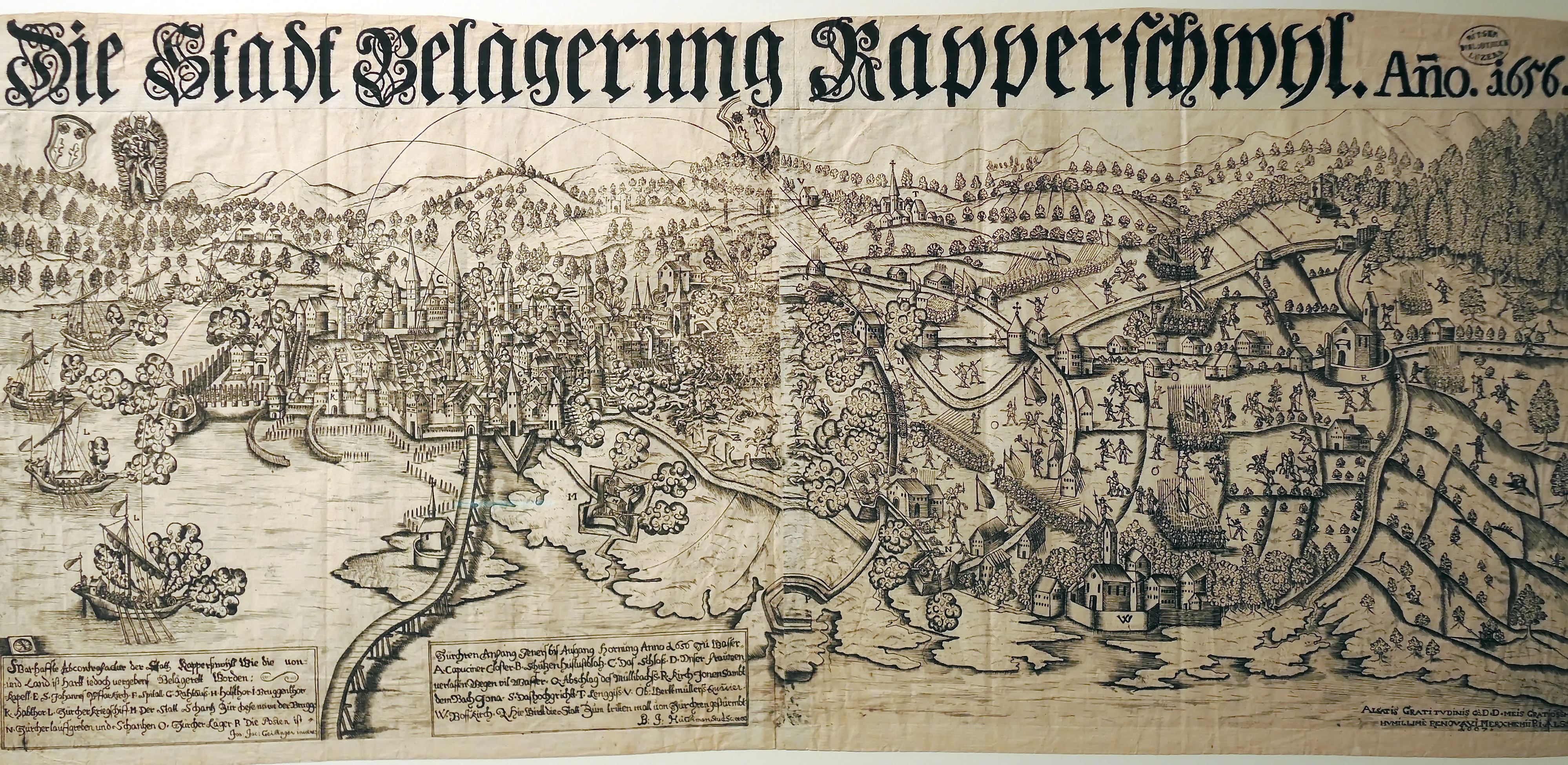
File:Belagerung der Stadt Rapperswil 1656 durch die Zürcher, Südansicht mit Umland, Geilinger-Hürlimann, 1667 Kupferstich - Stadtmuseum Rapperswil - 'Stadt in Sicht - Rapperswil in Bildern' 2013-10-05 16-07-49 (P7700).JPG
Original file (3,997 × 1,950 pixels, file size: 3.66 MB, MIME type: image/jpeg)
Captions
Captions
Summary
[edit].JPG&action=edit§ion=1)
| Description |
Deutsch: Das 2010/2012 runderneuerte Stadtmuseum in Rapperswil (SG) und seine Sammlung: Belagerung der Stadt Rapperswil 1656 durch die Zürcher unter General Rudolf Werdmüller. Südansicht der belagerten Stadt mit Umland aus der Vogelschau, Johann Jakob Geilinger (1611-1677), Johann Baptist Hürlimann, erschienen in Merxheim (Oberelsass) 1667, Kupferstich. «Warhaffte Abcontrefactur der Statt Rapperswyl wie die von Zürchren Anfang Jeners bis Ausgang Hornung Anno 1656 zu Wasser und Land ist hart iedoch vergebens belägerett worden.» |
| Date | |
| Source | Category:Stadtmuseum Rapperswil |
| Author | Johann Jakob Geilinger (1611-1677), Johann Baptist Hürlimann, erschienen in Merxheim (Oberelsass) 1667, Kupferstich, upload by Roland zh |
| Permission (Reusing this file) |
Fotografiert mit Einwilligung des Stadtmuseums Rapperswil |
| Camera location | | View this and other nearby images on: OpenStreetMap |
|---|
.JPG¶ms=047.227806_N_0008.817476_E_globe:Earth_type:camera_alt:107.2_source:exif_&language=en)
Licensing
[edit].JPG&action=edit§ion=2)
|
This work is in the public domain in its country of origin and other countries and areas where the copyright term is the author's life plus 70 years or fewer.
| |
| This file has been identified as being free of known restrictions under copyright law, including all related and neighboring rights. | |
File history
Click on a date/time to view the file as it appeared at that time.
| Date/Time | Thumbnail | Dimensions | User | Comment | |
|---|---|---|---|---|---|
| current | 22:22, 5 October 2013 | | 3,997 × 1,950 (3.66 MB) | Roland zh (talk | contribs) | == {{int:filedesc}} == {{Information |Description={{de|Das 2010/2012 runderneuerte Stadtmuseum in Rapperswil (SG) und seine Sammlung: '''[[:de:Belagerung von Rapperswil (1656)|Belagerung der Stadt... |
You cannot overwrite this file.
File usage on Commons
The following page uses this file:
,_Geilinger-H%C3%BCrlimann,_1667_Kupferstich_-_Stadtmuseum_Rapperswil_-_%27Stadt_in_Sicht_-_Rapperswil_in_Bildern%27_2013-10-05_16-08-53_(P7700).jpg)
Metadata
.JPG&oldid=879031904)
- October 2013 in Switzerland
- 2013 in Rapperswil-Jona
- Collections of Stadtmuseum Rapperswil
- Historical images of Rapperswil-Jona
- Historical images of Holzbrücke Rapperswil–Hurden
- Heilig Hüsli
- Historical images of Zürichsee
- Historical images of Obersee (Zürichsee)
- Siege of Rapperswil (1656)
- 1667 in Switzerland
- Old maps of Rapperswil-Jona
- Panoramics of Rapperswil