File:Bejisa Jan 2 2014 0530Z.jpg
Jump to navigation
Jump to search

Size of this preview: 692 × 599 pixels. Other resolutions: 277 × 240 pixels | 554 × 480 pixels | 999 × 865 pixels.
Original file (999 × 865 pixels, file size: 303 KB, MIME type: image/jpeg)
Captions
Captions
Add a one-line explanation of what this file represents
Summary
[edit]
| Description |
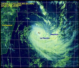
English: Bejisa (Southern Indian Ocean)
Jan. 2, 2014 La Reunion and Mauritius Getting Blasted by Bejisa Tropical Cyclone Bejisa's eye is just 85 miles west northwest of La Reunion, however, its influence is still very much felt on both islands. Maximum sustained winds in the storm are 110 knots (126.5 mph) with gusts to 135 knots (155 mph). This is a hurricane strength storm. Wave height has been measured at 35 feet. Both La Reunion and Mauritius islands are being affected by the outer bands of the storm. Bejisa is moving southeast and is at peak intensity. The storm will pass just west of La Reunion late on January 3, before veering southwest and weakening rapidly. The hazard on both islands consists of high swells, high winds and heavy rain. Gusts of 94 mph have been reported on La Reunion in the last hour. |
| Date | |
| Source | http://www.nasa.gov/sites/default/files/06s_020530sams_0.jpg?itok=xIstZt6U |
| Author | Image Credit: JTWC/SATOPS |
Licensing
[edit]
This file is a work of a sailor or employee of the U.S. Navy, taken or made as part of that person's official duties. As a work of the U.S. federal government, it is in the public domain in the United States.
|
 | |
| This file has been identified as being free of known restrictions under copyright law, including all related and neighboring rights. | ||
File history
Click on a date/time to view the file as it appeared at that time.
| Date/Time | Thumbnail | Dimensions | User | Comment | |
|---|---|---|---|---|---|
| current | 02:13, 3 January 2014 | | 999 × 865 (303 KB) | Oaktree b (talk | contribs) | {{Information |Description ={{en|1= Bejisa (Southern Indian Ocean) Jan. 2, 2014 La Reunion and Mauritius Getting Blasted by Bejisa Tropical Cyclone Bejisa's eye is just 85 miles west northwest of La Reunion, however, its influence is still very mu... |
You cannot overwrite this file.
File usage on Commons
The following page uses this file:
- File:Cyclone Bejisa 06s 020530sams 0.jpg (file redirect)