File:Beijing Subway System Map.svg
Jump to navigation
Jump to search

Size of this PNG preview of this SVG file: 600 × 600 pixels. Other resolutions: 240 × 240 pixels | 480 × 480 pixels | 768 × 768 pixels | 1,024 × 1,024 pixels | 2,048 × 2,048 pixels | 1,648 × 1,648 pixels.
Original file (SVG file, nominally 1,648 × 1,648 pixels, file size: 5.59 MB)
Captions
Captions
Add a one-line explanation of what this file represents
Summary
[edit]
| Description |
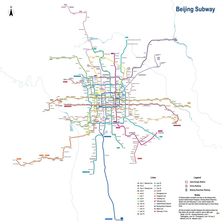
English: Map of Beijing Subway |
| Date | See the file history |
| Source | Own work |
| Author | Painjet |
Licensing
[edit]
I, the copyright holder of this work, hereby publish it under the following license:
This file is licensed under the Creative Commons Attribution-Share Alike 4.0 International license.
- You are free:
- to share – to copy, distribute and transmit the work
- to remix – to adapt the work
- Under the following conditions:
- attribution – You must give appropriate credit, provide a link to the license, and indicate if changes were made. You may do so in any reasonable manner, but not in any way that suggests the licensor endorses you or your use.
- share alike – If you remix, transform, or build upon the material, you must distribute your contributions under the same or compatible license as the original.
File history
Click on a date/time to view the file as it appeared at that time.
| Date/Time | Thumbnail | Dimensions | User | Comment | |
|---|---|---|---|---|---|
| current | 08:49, 1 January 2024 | | 1,648 × 1,648 (5.59 MB) | Painjet (talk | contribs) | 地铁17号线北段(工人体育场-未来科学城北)、16号线剩余段(榆树庄-宛平城)及苏州街站、11号线西段剩余段(金安桥-模式口)开通 |
| 16:17, 31 December 2022 |  | 4,944 × 4,944 (5.43 MB) | Painjet (talk | contribs) | 添加木樨地虚拟换乘 | |
| 14:35, 30 December 2022 |  | 4,944 × 4,944 (5.26 MB) | Painjet (talk | contribs) | 修正笔误 | |
| 14:23, 30 December 2022 |  | 4,944 × 4,944 (5.26 MB) | Painjet (talk | contribs) | 16号线南段、昌平线南延 | |
| 05:51, 8 January 2022 |  | 6,000 × 6,000 (5.13 MB) | Painjet (talk | contribs) | 添加真英文站名 | |
| 08:38, 30 December 2021 |  | 4,944 × 4,944 (4.51 MB) | Painjet (talk | contribs) | 调大尺寸 | |
| 08:34, 30 December 2021 |  | 1,648 × 1,648 (4.51 MB) | Painjet (talk | contribs) | 。 | |
| 08:17, 30 December 2021 |  | 1,648 × 1,648 (4.51 MB) | Painjet (talk | contribs) | 9条新线(段)开通 | |
| 15:13, 4 October 2021 |  | 1,648 × 1,648 (4.45 MB) | Painjet (talk | contribs) | 修正笔误 | |
| 11:58, 25 August 2021 |  | 1,648 × 1,648 (4.46 MB) | Painjet (talk | contribs) | 环球度假区,1-八通线贯通 |
You cannot overwrite this file.
File usage on Commons
The following 25 pages use this file:
- User:Chumwa/OgreBot/Public transport information/2020 December 21-31
- User:Chumwa/OgreBot/Public transport information/2020 May 11-20
- User:Chumwa/OgreBot/Public transport information/2020 May 21-31
- User:Chumwa/OgreBot/Public transport information/2020 October 11-20
- User:Chumwa/OgreBot/Public transport information/2020 September 11-20
- User:Chumwa/OgreBot/Public transport information/2021 August 21-31
- User:Chumwa/OgreBot/Public transport information/2021 December 21-31
- User:Chumwa/OgreBot/Public transport information/2021 March 11-20
- User:Chumwa/OgreBot/Public transport information/2021 October 1-10
- User:Chumwa/OgreBot/Public transport information/2022 December 21-31
- User:Chumwa/OgreBot/Public transport information/2022 January 1-10
- User:Chumwa/OgreBot/Public transport information/2024 January 1-10
- User:Chumwa/OgreBot/Transport Maps/2020 December 21-31
- User:Chumwa/OgreBot/Transport Maps/2020 May 11-20
- User:Chumwa/OgreBot/Transport Maps/2020 May 21-31
- User:Chumwa/OgreBot/Transport Maps/2020 October 11-20
- User:Chumwa/OgreBot/Transport Maps/2020 September 11-20
- User:Chumwa/OgreBot/Transport Maps/2021 August 21-31
- User:Chumwa/OgreBot/Transport Maps/2021 December 21-31
- User:Chumwa/OgreBot/Transport Maps/2021 March 11-20
- User:Chumwa/OgreBot/Transport Maps/2021 October 1-10
- User:Chumwa/OgreBot/Transport Maps/2022 December 21-31
- User:Chumwa/OgreBot/Transport Maps/2022 January 1-10
- User:Chumwa/OgreBot/Transport Maps/2024 January 1-10
- User:Painjet
File usage on other wikis
The following other wikis use this file:
- Usage on ca.wikipedia.org
- Usage on cs.wikipedia.org
- Usage on de.wikipedia.org
- Usage on en.wikipedia.org
- Usage on eo.wikipedia.org
- Usage on es.wikipedia.org
- Usage on fa.wikipedia.org
- Usage on fr.wikipedia.org
- Usage on hi.wikipedia.org
- Usage on id.wikipedia.org
- Usage on it.wikipedia.org
- Usage on ja.wikipedia.org
- Usage on ko.wikipedia.org
- Usage on ms.wikipedia.org
- Usage on nl.wikipedia.org
- Usage on th.wikipedia.org
- Usage on tr.wikipedia.org
- Usage on vi.wikipedia.org
- Usage on zh.wikipedia.org