File:Beehive-Taungamaru Island from Kawau Island.jpg
Jump to navigation
Jump to search

Size of this preview: 800 × 513 pixels. Other resolutions: 320 × 205 pixels | 640 × 410 pixels | 1,024 × 656 pixels | 1,280 × 821 pixels | 2,560 × 1,641 pixels | 6,240 × 4,000 pixels.
Original file (6,240 × 4,000 pixels, file size: 7.72 MB, MIME type: image/jpeg)
Captions
Captions
Add a one-line explanation of what this file represents
Summary
[edit]
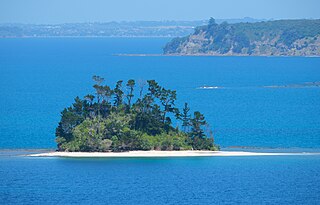
| Description | Beehive Island / Taungamaru Island from Kawau Island, looking south, Motuora Island behind it on the right, Whangaparaoa Peninsula in the distance |
| Date | |
| Source | Own work |
| Author | Pseudopanax at English Wikipedia |
| Camera location | | View this and other nearby images on: OpenStreetMap |
|---|
Licensing
[edit]
| I, the copyright holder of this work, release this work into the public domain. This applies worldwide. In some countries this may not be legally possible; if so: I grant anyone the right to use this work for any purpose, without any conditions, unless such conditions are required by law. |
| Annotations | This image is annotated: View the annotations at Commons |
File history
Click on a date/time to view the file as it appeared at that time.
| Date/Time | Thumbnail | Dimensions | User | Comment | |
|---|---|---|---|---|---|
| current | 05:16, 18 June 2024 | | 6,240 × 4,000 (7.72 MB) | Pseudopanax (talk | contribs) | == {{int:filedesc}} == {{Information |Description=Beehive Island / Taungamaru Island from Kawau Island, looking south, Motuora Island behind it on the right, Whangaparaoa Peninsula in the distance |Source={{Own}} |Date=2024-02-14 |Author={{user at project|Pseudopanax|wikipedia|en}} }} {{location|36|26|3.6|S|174|49|38.9|E}} == {{int:license-header}} == {{PD-self}} Category:Beehive Island / Taungamaro Island Category:Rodney, Auckland |
You cannot overwrite this file.
File usage on Commons
The following page uses this file:
File usage on other wikis
The following other wikis use this file:
- Usage on ceb.wikipedia.org
- Usage on en.wikipedia.org
- Usage on www.wikidata.org