File:Beeching2.svg
Jump to navigation
Jump to search

Size of this PNG preview of this SVG file: 364 × 599 pixels. Other resolutions: 146 × 240 pixels | 291 × 480 pixels | 466 × 768 pixels | 622 × 1,024 pixels | 1,244 × 2,048 pixels | 1,480 × 2,436 pixels.
Original file (SVG file, nominally 1,480 × 2,436 pixels, file size: 183 KB)
Captions
Captions
Add a one-line explanation of what this file represents
Summary
[edit]
| Description |
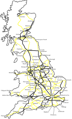
This is what the BR network could have looked like, by the 1980s, had the Beeching II developments gone ahead. All lines except those shown in bold would have been closed. Swathes of the country — notably North, South West Scotland and most of Wales — would no longer have lines. The plans were quietly shelved and closures slowed. Beeching resigned. Notes:
|
| Date | |
| Source | self-made, based on an a poster from Beeching II report |
| Author | Was done on behalf of the Wikipedia User:Btline (original image up-loader) by Cronholm144 via the Wikipedia Graphic Lab |
| Other versions | File:Beeching2_clear.svg |
Licensing
[edit]
I, Cronholm144, the copyright holder of this work, hereby publishes it under the following licenses:

|
Permission is granted to copy, distribute and/or modify this document under the terms of the GNU Free Documentation License, Version 1.2 or any later version published by the Free Software Foundation; with no Invariant Sections, no Front-Cover Texts, and no Back-Cover Texts. A copy of the license is included in the section entitled GNU Free Documentation License. |
| This file is licensed under the Creative Commons Attribution-Share Alike 3.0 Unported license. | ||
| Attribution: I, Cronholm144 | ||
| ||
| This licensing tag was added to this file as part of the GFDL licensing update. |
This file is licensed under the Creative Commons Attribution-Share Alike 2.5 Generic, 2.0 Generic and 1.0 Generic license.
Attribution: I, Cronholm144
- You are free:
- to share – to copy, distribute and transmit the work
- to remix – to adapt the work
- Under the following conditions:
- attribution – You must give appropriate credit, provide a link to the license, and indicate if changes were made. You may do so in any reasonable manner, but not in any way that suggests the licensor endorses you or your use.
- share alike – If you remix, transform, or build upon the material, you must distribute your contributions under the same or compatible license as the original.
You may select the license of your choice.
File history
Click on a date/time to view the file as it appeared at that time.
| Date/Time | Thumbnail | Dimensions | User | Comment | |
|---|---|---|---|---|---|
| current | 21:53, 31 May 2024 | | 1,480 × 2,436 (183 KB) | Hohum (talk | contribs) | Brighten |
| 12:24, 13 July 2007 |  | 1,480 × 2,436 (182 KB) | Time3000~commonswiki (talk | contribs) | Fix island obscuring text | |
| 12:21, 13 July 2007 |  | 1,480 × 2,436 (182 KB) | Time3000~commonswiki (talk | contribs) | Include islands (e.g. Isle of Mann) and fix typo | |
| 20:50, 10 July 2007 |  | 1,444 × 2,436 (198 KB) | Cronholm144 (talk | contribs) | tweak | |
| 01:22, 10 July 2007 |  | 1,444 × 2,436 (198 KB) | Cronholm144 (talk | contribs) | cities | |
| 02:09, 9 July 2007 |  | 1,284 × 2,436 (114 KB) | Cronholm144 (talk | contribs) | {{Information |Description=map o' Britain |Source=self-made |Date= |Author= Cronholm144 }} |
You cannot overwrite this file.
File usage on Commons
The following 4 pages use this file:
File usage on other wikis
The following other wikis use this file:
- Usage on azb.wikipedia.org
- Usage on cs.wikipedia.org
- Usage on de.wikipedia.org
- Usage on en.wikipedia.org
- Usage on es.wikipedia.org
- Usage on fr.wikipedia.org
- Usage on hu.wikipedia.org
- Usage on it.wikipedia.org
- Usage on ja.wikipedia.org
- Usage on lv.wikipedia.org
- Usage on pt.wikipedia.org
- Usage on ru.wikipedia.org
- Usage on ur.wikipedia.org
- Usage on zh.wikipedia.org