File:Bee Burrow Archeological District.jpg
Jump to navigation
Jump to search

Size of this preview: 758 × 600 pixels. Other resolutions: 303 × 240 pixels | 607 × 480 pixels | 971 × 768 pixels | 1,280 × 1,013 pixels | 2,560 × 2,026 pixels | 5,112 × 4,045 pixels.
Original file (5,112 × 4,045 pixels, file size: 2.78 MB, MIME type: image/jpeg)
Captions
Captions
Add a one-line explanation of what this file represents
|
This is an image of a place or building that is listed on the National Register of Historic Places in the United States of America. Its reference number is 84001296. |
| Camera location | | View this and other nearby images on: OpenStreetMap |
|---|
| Description |
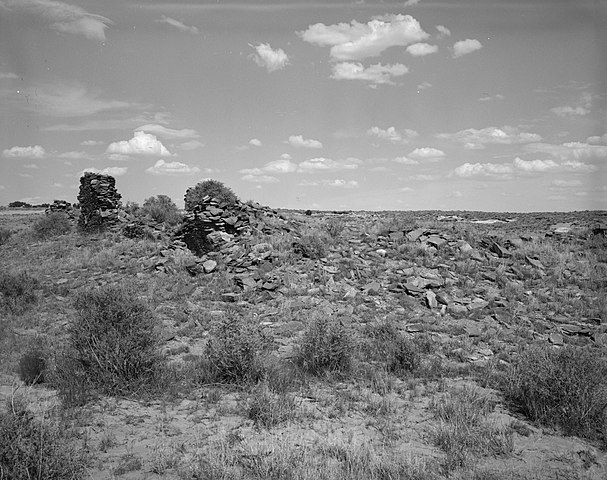
English: Ruins at the Bee Burrow Archeological District, located along Seven Lakes Wash north of Crownpoint in central McKinley County, New Mexico, United States. The remnants of a settlement of the Anasazi, it is listed as a historic district on the National Register of Historic Places. |
|||||
| Date | Unknown date | |||||
| Source | Library of Congress, Prints and Photograph Division HABS: NM,16-CROPO.V,3-13 | |||||
| Author | Robert Lyon | |||||
| Permission (Reusing this file) |
|


|
This image is available from the United States Library of Congress's Prints and Photographs division
under the digital ID hhh.nm0194. This tag does not indicate the copyright status of the attached work. A normal copyright tag is still required. See Commons:Licensing.
|
File history
Click on a date/time to view the file as it appeared at that time.
| Date/Time | Thumbnail | Dimensions | User | Comment | |
|---|---|---|---|---|---|
| current | 17:50, 2 June 2009 | | 5,112 × 4,045 (2.78 MB) | Cropbot (talk | contribs) | upload cropped version, operated by User:Finavon. Summary: border cropped |
| 15:42, 1 June 2009 |  | 5,500 × 4,417 (3.02 MB) | Nyttend (talk | contribs) | {{Information |Description={{en|Ruins at the {{w|Bee Burrow Archeological District}}, located along Seven Lakes Wash north of {{w|Crownpoint, New Mexico|Crownpoint}} in central {{w|McKinley County, New Mexico|McKinley County}}, {{w|New Mexico}}, {{w|Unite |
You cannot overwrite this file.
File usage on Commons
There are no pages that use this file.
File usage on other wikis
The following other wikis use this file:
- Usage on de.wikipedia.org
- Usage on en.wikipedia.org